
Old Baptist Church Branch facts for kids
Quick facts for kids Old Baptist Church Branch |
|
|---|---|


Location of Old Baptist Church Branch mouth
|
|
| Other name(s) | Tributary to Fishing Branch |
| Country | United States |
| State | Delaware |
| County | Kent |
| Physical characteristics | |
| Main source | Murderkill River divide about 0.25 miles west of Spring Hill, Delaware 22 ft (6.7 m) 38°58′38″N 075°26′07″W / 38.97722°N 75.43528°W |
| River mouth | Fishing Branch about 0.5 miles east of Spring Hill, Delaware 3 ft (0.91 m) 38°58′07″N 075°25′00″W / 38.96861°N 75.41667°W |
| Length | 2.00 mi (3.22 km) |
| Basin features | |
| Progression | southeast then northeast |
| River system | Mispillion River |
| Basin size | 1.75 square miles (4.5 km2) |
| Tributaries |
|
| Bridges | DE 1, Reynolds Road |
Old Baptist Church Branch is a small stream, about 2 miles (3.2 km) long. It flows into another stream called Fishing Branch, and both are located in Kent County, Delaware. This particular stream is unique because it's the only one in the entire United States with this name!
Contents
Where Does Old Baptist Church Branch Flow?
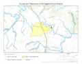
This stream starts near a place called Spring Hill, Delaware. It begins on a high point that separates the waters flowing towards the Murderkill River. From there, it flows first towards the southeast, then changes direction to the northeast. Finally, it joins Fishing Branch, which is about half a mile east of Spring Hill.
What is a Watershed?
A watershed is like a big bowl where all the rain and snow that falls eventually drains into a specific stream or river. The Old Baptist Church Branch watershed covers an area of about 1.75 square miles (4.5 square kilometers).
Rain and Forests in the Watershed
Every year, this area gets about 45.5 inches (115.6 cm) of rain. About 8% of the land in this watershed is covered by forests.
Images for kids
-
Course and Watershed of Old Baptist Church Branch

