Murderkill River facts for kids
Quick facts for kids Murderkill River |
|
|---|---|

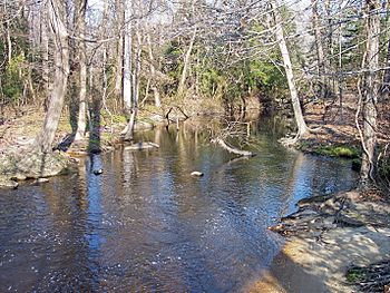
The Murderkill River downstream of Killens Pond in 2006
|
|
|
Location of the mouth of the Murderkill River
|
|
| Country | United States |
| State | Delaware |
| County | Kent |
| Physical characteristics | |
| Main source | near Felton 39°01′03″N 75°35′31″W / 39.01750°N 75.59194°W |
| River mouth | Delaware Bay Bowers 3 ft (0.91 m) 39°03′30″N 75°23′48″W / 39.05833°N 75.39667°W |
| Length | 22 mi (35 km) |
| Basin features | |
| Basin size | 106 sq mi (270 km2) |
| Tributaries |
|
| Waterbodies | Killen Pond Coursey Pond |
The Murderkill River is a river in central Delaware, United States. It flows into Delaware Bay. This river is about 22 miles (35 kilometers) long. It drains an area of 106 square miles (275 square kilometers). This area is part of the Atlantic coastal plain, which is a flat, low-lying region along the coast.
The Murderkill River flows entirely within southern Kent County. It starts near Felton and generally flows towards the east-northeast. Along its path, it goes through Killen Pond, which is part of Killens Pond State Park. It also passes through Coursey Pond and under Carpenters Bridge. The river then flows past Frederica before reaching Bowers. Here, it enters Delaware Bay. This spot is about 0.5 miles (1 kilometer) south of where the St. Jones River meets the bay.
The lower part of the Murderkill River is affected by tides. This tidal influence reaches upstream to just past Frederica. The United States Army Corps of Engineers considers the lower 10 miles (16 kilometers) of the river to be navigable. This means boats can travel on this section.
Contents
Understanding the River's Surroundings
The land around the Murderkill River is called its watershed. This is the area of land where all the water drains into the river. In 2002, the United States Environmental Protection Agency collected data about this watershed.
- About 55% of the land in the watershed is used for agriculture. This means there are many farms.
- About 17% of the land is covered by forests.
- Around 14% of the area is urban, meaning it has towns and cities.
- About 9% of the land is wetland, which are areas like swamps or marshes.
- The remaining 2% is water, including the river itself and other small bodies of water.
How the Murderkill River Got Its Name
The name "Murderkill River" might sound a bit scary, but it actually comes from an old Dutch word. Dick Carter, who is the Chair of the Delaware Heritage Commission, explains this.
Dutch Origins of "Kill"
The original name for the river was "Mother River." In Middle Dutch, "mother" is moeder, and "river" is Kille. So, the name was likely Moeder Kille. Later, when the British took over, they added the word "River" to its name. This made it "mother river river," which sounds a bit funny!
The word "kill" is often used in areas of North America where the Dutch used to live. These places were part of the Dutch colony called New Netherland. You can find "kill" in names of creeks, rivers, or tidal inlets. For example, there's the Bronx Kill in New York and the Schuylkill River in Pennsylvania.
"Muddy" Connection
Some people think the name might come from another Dutch word: modder. This word means "mud." Delaware's creeks and rivers often move slowly and have deep mud, especially in marshy areas. So, "Modder Kill" would mean "Muddy Creek" or "Muddy River." This makes sense because the river can be quite muddy.
There's another river in New York called Muddy Kill. This name clearly shows a connection to the older Dutch word for mud.
Other Names for the River
Over time, the Murderkill River has been known by a few different names. The Geographic Names Information System keeps track of these historical names.
- Mordare Kijhlen
- Mother Creek
- Mother Kill
- Motherkill
- Motherkiln Creek
- Mothers Creek
- Murder Kill Creek
- Murther Creek
- Murtherkill
 | Misty Copeland |
 | Raven Wilkinson |
 | Debra Austin |
 | Aesha Ash |


