Frederica, Delaware facts for kids
Quick facts for kids
Frederica, Delaware
|
|
|---|---|

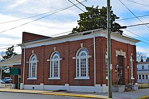
Town Hall
|
|
| Nickname(s):
Frogtown
|
|

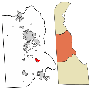
Location of Frederica in Kent County, Delaware.
|
|
| Country | |
| State | |
| County | Kent |
| Government | |
| • Type | Council-manager |
| Area | |
| • Total | 1.74 sq mi (4.51 km2) |
| • Land | 1.74 sq mi (4.51 km2) |
| • Water | 0.00 sq mi (0.00 km2) |
| Elevation | 16 ft (5 m) |
| Population
(2020)
|
|
| • Total | 1,073 |
| • Density | 616.31/sq mi (237.95/km2) |
| Time zone | UTC−5 (Eastern (EST)) |
| • Summer (DST) | UTC−4 (EDT) |
| ZIP code |
19946
|
| Area code(s) | 302 |
| FIPS code | 10-28440 |
| GNIS feature ID | 213981 |
| Website | Frederica, Delaware |
Frederica is a small town in Kent County, Delaware, United States. It is part of the larger Dover metropolitan area. In 2020, about 1,073 people lived there.
A cool fact about the area is that ILC Dover is located nearby. This company made the special spacesuits for the Apollo and Skylab astronauts in the 1960s and 1970s. They also created parts of the Space Shuttle's Extravehicular Mobility Unit (EMU), which is the suit astronauts wear for spacewalks!
Contents
History of Frederica

The land where Frederica now stands was first given to Boneny Bishop by William Penn in 1681. This spot, located on a bend of the Murderkill River, was originally called Indian Point. Later, it became known as Johnny Cake Landing. The part of the waterfront where most ships docked was surveyed in 1758 and named Goforth's Landing.
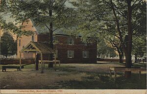
The rest of the town was planned out by Jonathan Emerson in 1772. In 1796, the community's name changed from Johnny Cake Landing to Frederica Landing. One of Emerson's daughters asked for the change. She thought "Johnny Cake Landing" sounded too informal for a town so close to Barratt's Chapel, a very important place for Methodism. The town of Frederica officially became a town in 1826. It was briefly unincorporated in 1855 but became a town again in 1865.
Frederica was built along the Murderkill River, about 6 miles (9.7 km) from the Delaware Bay. The river was deep enough for ships to travel there. The town was surrounded by wetlands, which are marshy areas. Because of the many frogs living in these wetlands, Frederica earned the nickname "Frogtown."
Frederica's Shipping Past
Frederica grew into a busy center for shipping and shipbuilding. Its location on the navigable Murderkill River made this possible. For many years, shipping and building ships were the main jobs in town. Frederica was connected by water to other towns in Kent County and even to Philadelphia. The town's success depended on these water routes because roads were often muddy and hard to use back then.
Important goods shipped from Frederica included:
- Bacon and beef
- Corn and wheat flour
- Cedar shingles
- Cheese and butter
- Tar, pitch, and hardwood boards
Impact of the Railroad
In 1857, the Delaware Railroad was built across the state. This new railroad caused Frederica's importance as a shipping center to decline. The railroad made it easier to transport goods by land, away from the river ports. People in Frederica who worked in shipping did not want the railroad built near their town. This decision slowed the town's growth and made Frederica feel more isolated from other towns. The Delaware Railroad was built further west, through Dover and Felton.
Later, Frederica tried to get its own railroad connection. They wanted a line from Dover to Milford that would pass through Frederica. They also pushed for a 7-mile (11 km) branch of the Delaware Railroad from Felton to Frederica. However, neither of these plans worked out.
Modern Frederica
The last shipyard in Frederica closed around 1890. But other businesses started to grow in the town. By 1887, Frederica had three canneries, which processed food. There were also factories making fertilizer, hats, and brushes. Other businesses included a cooper (someone who makes barrels), a butcher, a hotel, a clothing store, and ten general stores.
A steamship service connected Frederica with Philadelphia until the Great Depression began. In the 1920s, improvements to U.S. Route 113 included a raised road (causeway) into Frederica. This road cut the town off from the Delaware Bay. As roads improved in the 20th century, it became easier to travel to Harrington, Dover, and Wilmington. This meant the steamship to Philadelphia was no longer as necessary.
Over time, shipping activity in Frederica decreased, and the port became quiet. Many canneries and businesses in the town closed. U.S. Route 113 was later moved to bypass Frederica to the east, along what is now Delaware Route 1. Today, Frederica is a peaceful town that has not changed as much as many other places in the United States.
Several historic places in Frederica are listed on the National Register of Historic Places. These include the Barratt Hall, Barratt's Chapel, Bonwell House, Frederica Historic District, and Mordington.
Geography of Frederica
Frederica is located at 39°00′32″N 75°27′57″W / 39.00889°N 75.46583°W. This means it is at 39.0090017 degrees North latitude and -75.4657542 degrees West longitude.
The United States Census Bureau says the town covers about 0.8 square miles (2.1 km2) of land. There is no water area within the town limits.
Because of the marshy land around the Murderkill River south of town, residents sometimes notice a strong smell on hot summer days. Also, some roads leading out of town to DE 1 often flood during very high tides or heavy rains.
Climate in Frederica
The weather in Frederica has hot, humid summers. Winters are usually mild to cool. According to the Köppen Climate Classification system, Frederica has a humid subtropical climate. This type of climate is shown as "Cfa" on climate maps. It means the area has warm temperatures and plenty of rainfall throughout the year.
| Climate data for Frederica, Delaware | |||||||||||||
|---|---|---|---|---|---|---|---|---|---|---|---|---|---|
| Month | Jan | Feb | Mar | Apr | May | Jun | Jul | Aug | Sep | Oct | Nov | Dec | Year |
| Record high °F (°C) | 76 (24) |
78 (26) |
84 (29) |
95 (35) |
96 (36) |
102 (39) |
103 (39) |
103 (39) |
99 (37) |
91 (33) |
86 (30) |
76 (24) |
103 (39) |
| Mean daily maximum °F (°C) | 43 (6) |
45 (7) |
54 (12) |
64 (18) |
73 (23) |
82 (28) |
87 (31) |
85 (29) |
78 (26) |
68 (20) |
58 (14) |
48 (9) |
65 (19) |
| Mean daily minimum °F (°C) | 24 (−4) |
25 (−4) |
33 (1) |
42 (6) |
52 (11) |
62 (17) |
67 (19) |
65 (18) |
57 (14) |
46 (8) |
36 (2) |
29 (−2) |
45 (7) |
| Record low °F (°C) | −7 (−22) |
−4 (−20) |
4 (−16) |
20 (−7) |
30 (−1) |
40 (4) |
47 (8) |
43 (6) |
34 (1) |
19 (−7) |
13 (−11) |
2 (−17) |
−7 (−22) |
| Average precipitation inches (mm) | 4.08 (104) |
3.30 (84) |
4.51 (115) |
3.50 (89) |
4.03 (102) |
3.31 (84) |
3.69 (94) |
4.61 (117) |
4.08 (104) |
3.48 (88) |
3.32 (84) |
3.59 (91) |
45.5 (1,156) |
| Source: The Weather Channel | |||||||||||||
Population Changes in Frederica
| Historical population | |||
|---|---|---|---|
| Census | Pop. | %± | |
| 1870 | 588 | — | |
| 1880 | 693 | 17.9% | |
| 1890 | 621 | −10.4% | |
| 1900 | 706 | 13.7% | |
| 1910 | 659 | −6.7% | |
| 1920 | 611 | −7.3% | |
| 1930 | 589 | −3.6% | |
| 1940 | 645 | 9.5% | |
| 1950 | 675 | 4.7% | |
| 1960 | 863 | 27.9% | |
| 1970 | 878 | 1.7% | |
| 1980 | 864 | −1.6% | |
| 1990 | 761 | −11.9% | |
| 2000 | 648 | −14.8% | |
| 2010 | 774 | 19.4% | |
| 2020 | 1,073 | 38.6% | |
| U.S. Decennial Census | |||
According to the census of 2000, there were 648 people living in Frederica. These people lived in 246 households, and 168 of those were families. The population density was about 769 people per square mile (297 per km2).
About 32.9% of households had children under 18 living with them. About 43.9% of households were married couples living together. The average household had 2.63 people, and the average family had 3.17 people.
The median age in the town was 35 years old. About 29.5% of the population was under 18. About 13.3% of the population was 65 years or older.
Education in Frederica
Most of Frederica is located within the Lake Forest School District. However, a small part of the town is in the Milford School District. Students living in the Lake Forest areas typically attend Lake Forest High School.
Town Services and Transportation
Transportation in Frederica
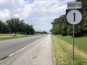
Delaware Route 1 (DE 1) runs just east of Frederica. Frederica Road goes through the town from north to south, connecting to DE 1 at two exits: South Frederica (exit 83) and North Frederica (exit 86). DE 1 goes north towards Dover and Wilmington. It goes south towards Milford and the Delaware Beaches.
Delaware Route 12 (DE 12) starts at DE 1 at the North Frederica interchange. It travels through the town along Frederica Road. In the town center, it uses a one-way pair of David Street (eastbound) and Front Street (westbound). DE 12 then continues west towards Felton. Carpenter Bridge Road starts at DE 12 on the west side of Frederica and goes southwest towards Harrington.
DART First State provides bus service in Frederica. Route 303 connects Frederica north to Dover and south to Milford and Georgetown. There is also a park and ride lot at the South Frederica interchange. This lot is served by Route 307, which goes north to Dover and south to Lewes. A park and ride is a place where people can park their cars and then take a bus or other public transportation.
Utilities in Frederica
Several companies provide important services to the town of Frederica:
- Electricity: Delmarva Power, which is part of Exelon, provides electricity to homes and businesses.
- Natural Gas: Chesapeake Utilities supplies natural gas to the town.
- Water: The Town of Frederica Water Department/Public Works is responsible for providing water service.
- Trash and Recycling: Charlie's Waste Services handles trash and recycling collection in Frederica.
See also
 In Spanish: Frederica (Delaware) para niños
 | Charles R. Drew |
 | Benjamin Banneker |
 | Jane C. Wright |
 | Roger Arliner Young |


