Old World Wisconsin facts for kids
Quick facts for kids Old World Wisconsin |
|
|---|---|
|
IUCN Category V (Protected Landscape/Seascape)
|
|
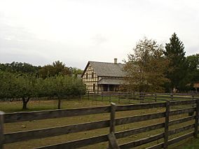
Koepsel House at Old World Wisconsin
|
|
| Location | Eagle, Wisconsin, United States |
| Area | 480 acres (190 ha) |
| Established | 1976 |
| Governing body | Wisconsin Historical Society |
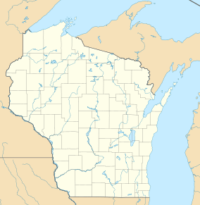
Old World Wisconsin is a super cool open-air museum located near Eagle, in Waukesha County, Wisconsin, United States. It's like stepping back in time! The museum shows you what homes and daily life were like for settlers in Wisconsin during the 1800s.
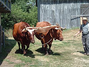
You'll find different areas that show the traditions of various groups of people who moved to the state. People dressed in old-fashioned clothes act out the jobs and chores of typical settlers from that time. It's a fun way to learn about history!
Contents
What is Old World Wisconsin?
This amazing museum opened in 1976. The Wisconsin Historical Society owns and runs it. It's the biggest outdoor museum in the United States that focuses on rural life.
The museum covers about 480 acres of rolling hills and woods. It's right next to the Kettle Moraine State Forest South Unit. You can explore more than 60 historic buildings here. These include old farmhouses with furniture and barns, plus a village from the 1880s with shops and other town buildings.
What can you do there?
At Old World Wisconsin, you can visit the Ramsey barn, which has a gift shop. The Brewhouse shows how people used to brew drinks and even offers samples. The Creamery is a great spot for lunch, snacks, and frozen custard. There's also a large event space in the round Clausing Barn. Trams can take you between different areas, like the Scandinavian farms and the Crossroads Village.
How Old World Wisconsin Started
Old World Wisconsin exists thanks to people who wanted to save old buildings. A German immigrant named Hans Kuether and an architect named Richard W. E. Perrin were very important. Perrin loved saving historic buildings. He even made a list of 76 buildings in Wisconsin that he thought should be protected.
The Idea for the Museum
Perrin first thought of creating an outdoor museum in 1964. He called it a "Pioneer Park." He got the idea after visiting outdoor museums in Europe, like Skansen in Sweden, back in 1953. He used Skansen as his model for the Wisconsin park.
The real work to create the museum began in 1966. The University of Wisconsin and the Wisconsin Historical Society worked together. They made plans for an outdoor museum. In 1968, a big report was made, and the project was named Old World Wisconsin.
Moving Buildings and Opening Day
It took a lot of effort to get the museum ready. In 1971, the state decided to give about 560 acres of land from the Kettle Moraine State Forest to the Historical Society for the museum.
Old buildings from all over Wisconsin were carefully taken apart and moved to the museum site. This was a huge job! The park was officially opened on June 30, 1976. This was just in time for the United States Bicentennial celebration, which was America's 200th birthday!
Tornado Damage
On June 21, 2010, a tornado hit the museum. It knocked down many trees on the grounds. Because of the big cleanup needed, a special "Old World 4th of July" event had to be canceled that year.
Exploring the Villages
The museum is divided into different areas, or "villages." Each village shows what life was like for different groups of immigrants who settled in Wisconsin.
- African American Village: Here you can see the Pleasant Ridge Cemetery Chapel, the Shepard Family Cemetery, and the United Brethren Church.
- Danish American Village: Visit the Pedersen Farm to see how Danish settlers lived.
- Finnish American Village: Explore the Rankinen Farm and Ketola Farm.
- German American Village: Check out the Koepsel Farm, Schottler Farm, and Schulz Farm. The Koepsel House and Christian Turck House (also known as Schottler Farm) are very old and important buildings.
- Norwegian American Village: Discover the Fossebrekke Farm, Kvaale Farm, and Raspberry School.
- Polish American Village: See the Kruza House.
- Yankee/1880s Village: This area shows a typical crossroads village from the 1880s. You can find the Harmony Town Hall, Four Mile Inn, Sisel Shoe Shop, Benson House, Grotelueschen Blacksmith Shop, Peterson Wagon Shop, Thomas General Store, Mary Hafford House, and St. Peter's Church. There's even a new exhibit called "Catch Wheel Fever" added in 2014!
Different Cultures in the Yankee Village
The Yankee Village also includes buildings from other European settlers. This shows how different cultures came together in Wisconsin in the 1800s:
- The Sisel shoe shop was owned by a Czech family.
- The Grotelueschen Blacksmith Shop was run by a German family.
- The Peterson Wagon Shop was owned by a Scandinavian family.
Buildings at Old World Wisconsin
Many of the buildings at Old World Wisconsin were moved from other places across Wisconsin. Three of these buildings are so important that they are listed on the National Register of Historic Places.
| Structure name | Village | location | Image | Built | Notes |
|---|---|---|---|---|---|
| Bicycle Shop | The Green | 42°52′15″N 88°29′22″W / 42.870732°N 88.489350°W |  |
||
| Caldwell Hall Education Center | The Green | 42°52′14″N 88°29′22″W / 42.870523°N 88.489429°W |  |
||
| Clausing Barn/Gift Shop | The Green | 42°52′21″N 88°29′27″W / 42.872608°N 88.490737°W |  |
||
| Pergola | The Green | 42°52′19″N 88°29′26″W / 42.871920°N 88.490589°W |  |
2016 | |
| Ramsey Barn | The Green | 42°52′17″N 88°29′27″W / 42.871382°N 88.490823°W |  |
||
| Shelter | The Green | 42°52′18″N 88°29′26″W / 42.871668°N 88.490589°W |  |
||
| Guest Services/Family History Center | The Green | 42°52′19″N 88°29′26″W / 42.872080°N 88.490572°W |  |
||
| United Brethren Church | African-American | 42°52′02″N 88°29′49″W / 42.867242°N 88.496876°W |  |
||
| Pleasant Ridge Chapel | African-American | 42°52′03″N 88°29′43″W / 42.867566°N 88.495333°W |  |
||
| Pleasant Ridge Cemetery | African-American | 42°52′03″N 88°29′48″W / 42.867548°N 88.496626°W |  |
||
| Shepard Family Cemetery | African-American | 42°52′04″N 88°29′43″W / 42.867677°N 88.495414°W | 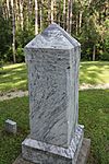 |
||
| Pedersen House | Danish | 42°51′43″N 88°29′24″W / 42.861953°N 88.490058°W |  |
1872 | Moved from Polk County |
| Pedersen Barn | Danish | 42°51′43″N 88°29′26″W / 42.861824°N 88.490488°W |  |
early 1870s | Moved from Polk County |
| Ketola Barn | Finnish | 42°51′56″N 88°29′29″W / 42.865568°N 88.491266°W |  |
Moved from Oulu, Bayfield County | |
| Ketola House | Finnish | 42°51′55″N 88°29′30″W / 42.865278°N 88.491531°W |  |
Log house moved from Oulu, Bayfield County | |
| Lantta Hay Barn (Ketola Farm) |
Finnish | 42°51′53″N 88°29′29″W / 42.864850°N 88.491474°W |  |
||
| Ronkainen Sauna (Ketola Farm) |
Finnish | 42°51′54″N 88°29′28″W / 42.865137°N 88.491223°W |  |
||
| Kortesmaa Granary (Ketola Farm) |
Finnish | 42°51′55″N 88°29′28″W / 42.865292°N 88.491181°W |  |
||
| Makela Stable (Ketola Farm) |
Finnish | 42°51′56″N 88°29′28″W / 42.865456°N 88.491179°W |  |
||
| Rankinen Outhouse (Ketola Farm) |
Finnish | 42°51′56″N 88°29′28″W / 42.865536°N 88.491135°W |  |
||
| Rankinen House | Finnish | 42°51′57″N 88°29′24″W / 42.865910°N 88.490011°W |  |
||
| Rankinen Barn | Finnish | 42°51′56″N 88°29′25″W / 42.865651°N 88.490219°W |  |
||
| Kortesmaa Outhouse (Rankinen Farm) |
Finnish | 42°51′56″N 88°29′25″W / 42.865583°N 88.490195°W | |||
| Koepsel House | German | 42°51′59″N 88°29′51″W / 42.866347°N 88.497387°W |  |
1860 | Listed on the NRHP in 1973 |
| Barn (Koepsel Farm) |
German | 42°51′58″N 88°29′52″W / 42.866163°N 88.497776°W | |||
| Brewing Shed (Koepsel Farm) |
German | 42°52′01″N 88°29′55″W / 42.866807°N 88.498581°W | |||
| Outhouse (Koepsel Farm) |
German | 42°51′58″N 88°29′51″W / 42.866094°N 88.497472°W |  |
||
| Stable (Koepsel Farm) |
German | 42°51′59″N 88°29′53″W / 42.866345°N 88.497924°W | 1850 | Moved from town of Emmet, Dodge County | |
| Hog pen (Koepsel Farm) |
German | 42°52′00″N 88°29′51″W / 42.866631°N 88.497474°W |  |
||
| Wood Shop (Koepsel Farm) |
German | 42°51′59″N 88°29′52″W / 42.866472°N 88.497788°W | |||
| Schultz House | German | 42°51′54″N 88°29′52″W / 42.864978°N 88.497693°W |  |
||
| Schultz Barn | German | 42°51′56″N 88°29′52″W / 42.865447°N 88.497717°W |  |
||
| Schultz Stable | German | 42°51′55″N 88°29′52″W / 42.865244°N 88.497901°W |  |
||
| Schottler House | German | 42°51′56″N 88°29′57″W / 42.865566°N 88.499292°W |  |
1846 | Log house moved from Washington County. Listed on the NRHP in 1973 as Christian Turck House. |
| Held Barn (Schottler farm) |
German | 42°51′56″N 88°29′58″W / 42.865435°N 88.499535°W |  |
||
| Jung Barn (Schottler farm) |
German | 42°51′55″N 88°29′58″W / 42.865289°N 88.499378°W |  |
||
| Fassbender Granary (Schottler farm) |
German | 42°51′55″N 88°29′57″W / 42.865295°N 88.499144°W |  |
||
| Kessel Bakehouse (Schottler farm) |
German | 42°51′56″N 88°29′57″W / 42.865421°N 88.499217°W |  |
||
| Jung Smokehouse (Schottler farm) |
German | 42°51′56″N 88°29′57″W / 42.865516°N 88.499087°W |  |
||
| Abandoned House | Norwegian | 42°51′32″N 88°29′26″W / 42.858767°N 88.490477°W | |||
| Abandoned Barn | Norwegian | 42°51′31″N 88°29′27″W / 42.858536°N 88.490749°W | |||
| Kvaale House | Norwegian | 42°51′32″N 88°29′38″W / 42.858800°N 88.493865°W |  |
||
| Dahlen Corncrib (Kvaale Farm) |
Norwegian | 42°51′32″N 88°29′39″W / 42.858938°N 88.494161°W | |||
| Sorbergshagen Barn (Kvaale Farm) |
Norwegian | 42°51′32″N 88°29′40″W / 42.858925°N 88.494453°W |  |
||
| Lisbakken Granery (Kvaale Farm) |
Norwegian | 42°51′31″N 88°29′40″W / 42.858707°N 88.494485°W |  |
||
| Bosboen Barn (Kvaale Farm) |
Norwegian | 42°51′31″N 88°29′39″W / 42.858528°N 88.494209°W |  |
||
| Otteson Outhouse (Kvaale Farm) |
Norwegian | 42°51′31″N 88°29′38″W / 42.858627°N 88.493951°W | |||
| Veggli House (Kvaale Farm) |
Norwegian | 42°51′31″N 88°29′38″W / 42.858607°N 88.493803°W | |||
| Fossebrekke House | Norwegian | 42°51′34″N 88°29′37″W / 42.859347°N 88.493674°W |  |
1845 | This is the oldest building on the site! |
| Raspberry Schoolhouse | Norwegian | 42°51′33″N 88°29′33″W / 42.859044°N 88.492403°W |  |
||
| Ward District Schoolhouse No. 3 | Norwegian | 42°51′27″N 88°29′37″W / 42.857570°N 88.493729°W |  |
1849 | Listed on the NRHP in 1981. |
| Kruza House | Polish | 42°51′52″N 88°29′57″W / 42.864375°N 88.499057°W |  |
||
| Kaczorowski Outhouse | Polish | 42°51′51″N 88°29′56″W / 42.864283°N 88.498937°W | 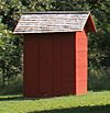 |
||
| Roadside Cross | Polish | 42°51′53″N 88°29′56″W / 42.864729°N 88.498945°W | |||
| Benson House | Yankee/1880s Village | 42°52′06″N 88°29′30″W / 42.868348°N 88.491758°W |  |
||
| Benson Barn | Yankee/1880s Village | 42°52′06″N 88°29′32″W / 42.868393°N 88.492228°W | |||
| Benson Gezebo | Yankee/1880s Village | 42°52′06″N 88°29′31″W / 42.868322°N 88.492029°W | |||
| Blacksmith Shop | Yankee/1880s Village | 42°52′07″N 88°29′30″W / 42.868508°N 88.491727°W |  |
||
| Hafford House | Yankee/1880s Village | 42°52′09″N 88°29′32″W / 42.869225°N 88.492237°W |  |
||
| Four Mile House | Yankee/1880s Village | 42°52′05″N 88°29′30″W / 42.867983°N 88.491581°W |  |
||
| Harmony Town Hall | Yankee/1880s Village | 42°52′03″N 88°29′22″W / 42.867524°N 88.489458°W |  |
1876 | Originally built in Town of Harmony in Rock County. |
| Peterson Wagon Shop | Yankee/1880s Village | 42°52′07″N 88°29′30″W / 42.868664°N 88.491753°W |  |
||
| Sisel Shoe Shop | Yankee/1880s Village | 42°52′05″N 88°29′31″W / 42.868014°N 88.492082°W |  |
||
| Sisel Barn | Yankee/1880s Village | 42°52′04″N 88°29′32″W / 42.867676°N 88.492207°W | |||
| Stage | Yankee/1880s Village | 42°52′07″N 88°29′29″W / 42.868508°N 88.491284°W | |||
| Thomas General Store | Yankee/1880s Village | 42°52′07″N 88°29′29″W / 42.868677°N 88.491337°W |  |
1876 | Moved from Waukesha County. |
| Barn (Thomas Store) |
Yankee/1880s Village | 42°52′08″N 88°29′28″W / 42.868886°N 88.491025°W |  |
||
| Outhouse (Thomas Store) |
Yankee/1880s Village | 42°52′07″N 88°29′28″W / 42.868714°N 88.49102°W |  |
||
| Loomer Barn | Yankee/1880s Village | 42°52′05″N 88°29′25″W / 42.867991°N 88.490297°W |  |
1858 | This barn shows how farmers used to thresh (separate grain) wheat. |
| Sanford House | Yankee/1880s Village | 42°52′06″N 88°29′25″W / 42.868430°N 88.490265°W |  |
||
| St. Peter's Church | Yankee/1880s Village | 42°52′11″N 88°29′30″W / 42.869695°N 88.491801°W |  |
1838 | Moved from St. Francis. |
| Administrative offices | Service/Admin/Misc | 42°51′45″N 88°30′05″W / 42.862546°N 88.501355°W | |||
| Concession Stand | Service/Admin/Misc | 42°51′28″N 88°29′33″W / 42.857723°N 88.492629°W | |||
| Entrance Sign (North 1 of 2) | Service/Admin/Misc | 42°51′51″N 88°29′16″W / 42.864104°N 88.487687°W |  |
||
| Entrance Sign (South 2 of 2) | Service/Admin/Misc | 42°51′50″N 88°29′16″W / 42.863824°N 88.487754°W |  |
||
| Farmhouse | Service/Admin/Misc | 42°51′28″N 88°30′00″W / 42.857907°N 88.499971°W | |||
| Farmhouse barn | Service/Admin/Misc | 42°51′28″N 88°30′03″W / 42.857759°N 88.500708°W | |||
| Farmhouse garage | Service/Admin/Misc | 42°51′29″N 88°30′00″W / 42.858009°N 88.500124°W | |||
| Farmhouse shed | Service/Admin/Misc | 42°51′29″N 88°30′02″W / 42.857920°N 88.500573°W | |||
| Farmhouse wellhouse | Service/Admin/Misc | 42°51′28″N 88°30′02″W / 42.857823°N 88.500460°W | |||
| Greenhouse | Service/Admin/Misc | 42°51′29″N 88°30′00″W / 42.858095°N 88.499865°W | |||
| Machinery building | Service/Admin/Misc | 42°51′30″N 88°30′00″W / 42.858327°N 88.499957°W | |||
| Maintenance building | Service/Admin/Misc | 42°51′33″N 88°30′07″W / 42.859052°N 88.501964°W | |||
| Maintenance shed | Service/Admin/Misc | 42°51′31″N 88°30′07″W / 42.858658°N 88.501923°W | |||
| Maintenance shed | Service/Admin/Misc | 42°51′33″N 88°30′08″W / 42.859065°N 88.502321°W | |||
| Picnic Shelter | Service/Admin/Misc | 42°51′28″N 88°29′35″W / 42.857824°N 88.493041°W | |||
| Public Restrooms (German Area) |
Service/Admin/Misc | 42°52′01″N 88°29′55″W / 42.866813°N 88.498577°W | |||
| Public Restrooms (Norwegian Area) |
Service/Admin/Misc | 42°51′28″N 88°29′34″W / 42.857850°N 88.492655°W | |||
| Rustic Restrooms | Service/Admin/Misc | 42°51′53″N 88°29′25″W / 42.864614°N 88.490286°W |  |
||
| Storage Barn | Service/Admin/Misc | 42°51′33″N 88°29′56″W / 42.859129°N 88.498792°W | |||
| Tram stop shelter | Service/Admin/Misc | 42°52′05″N 88°29′23″W / 42.867992°N 88.489835°W |
 | Jackie Robinson |
 | Jack Johnson |
 | Althea Gibson |
 | Arthur Ashe |
 | Muhammad Ali |


