Oldcotes Dyke facts for kids
Quick facts for kids Oldcotes Dyke |
|
|---|---|

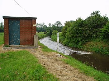
The weir and gauging station that measure flow on Oldcotes Dyke before it joins the River Ryton
|
|
| Country | England |
| Physical characteristics | |
| Main source | Streams near Ravenfield and Hellaby 410 feet (125 m) |
| River mouth | River Ryton, Blyth 39 feet (12 m) 53°22′54″N 1°03′46″W / 53.38165°N 1.06282°W |
| Basin features | |
| Tributaries |
|
The Oldcotes Dyke is the final part of a river system in England. It flows through parts of northern Nottinghamshire and South Yorkshire. This river system has a long history. In the past, it powered seven water mills. It also flowed through the beautiful grounds of Roche Abbey, a historic monastery. Oldcotes Dyke eventually joins the River Ryton.
Contents
Journey of the Oldcotes Dyke
The river starts as a small stream near Ravenfield, about 410 feet (125 m) high. It flows east, passing under roads and even a motorway. It then forms the edge of the Hellaby Industrial Park. Further along, it is joined by other streams. One of these is Newhall Dike.
The river then turns east again, flowing past Maltby. Here, it meets Kingsforth Brook. This brook flows through a wooded area called King's Pond Plantation. After passing under more roads, it becomes Maltby Dike.
Historic Mills and Abbey Life
The first old mill on the river is Hooton Levitt mill. The mill building is very old, from the late 1700s. It was used to grind corn. Even though the water wheel is gone, you can still see where it was. Near here, a sewage treatment works used to be. Now, this area is becoming a nature reserve.
The river continues south-east, passing the modern sewage works. Then, it reaches the famous Roche Abbey. This abbey was founded by monks in 1147. After the monasteries were closed down in the 1530s, the abbey land was sold. Later, a famous landscape designer named Capability Brown worked on the abbey grounds in 1760. He changed the river's path to create a winding stream and a lake.
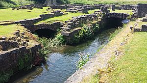
Over time, people wanted to see the original abbey layout. So, in the late 1800s, the site was excavated. After World War I, the lake was drained. The original water channels were found and put back. This work also helped provide jobs for people who needed them. The river's water was used to power a mill during the time the monks lived there.
Hooton Dike and Laughton Pond
Just below Roche Abbey, the river is joined by Hooton Dike. This dike starts near Thurcroft Colliery, a former coal mine. It flows east, passing under old railway lines. It then becomes Brookhouse Dike and later Hooton Brook.
Hooton Brook then flows into Laughton Pond. This is a large, artificial lake created by Capability Brown in 1776. At one end of the pond, there is a 10 feet (3.0 m) waterfall. Near it, there is an old tunnel. This tunnel connects the pond to Maltby Dike. It seems to be from medieval times, but it was changed in the 1760s.
Firbeck Dike and Country Estates
The river continues through Sandbeck Park. Here, there was another corn mill called Roche Abbey Mill. The old farmhouse still stands, but the mill is gone. Further on is Stone Mill, which dates back to the 1600s.
The river then becomes Firbeck Dike. It flows around the Firbeck Hall estate. Here, it meets Lamb Lane Dike. This dike flows from a large lake at Lingodel Farm. It also passes through the Park Hill estate. This estate was once owned by Anthony St Leger, who started the famous St Leger Stakes horse race in 1776.
Firbeck Hall itself is a country house with parts from the 1500s. It became a country club in 1935. However, it closed due to World War II. The level of the lakes at Firbeck Hall is controlled by a weir. This weir is part of a bridge built in the early 1800s.
Further east, there was Yews Mill. Not much of the original mill remains. It might have been a paper mill. Another small building near a bridge, dated 1806, is also thought to have been a mill.
Oldcotes Dyke's Final Stretch
After the mill streams rejoin, the river officially becomes Oldcotes Dyke. It flows south of Oldcotes. Goldthorpe Mill is here, an old building from the 1700s. It has been turned into a house. You can still see its steel water wheel from the late 1800s.
Further east is Oldcotes Mill. This mill also dates from the late 1700s. It still has much of its original machinery. Both Goldthorpe and Oldcotes mills produced flour in the 1880s.
The river then flows through Fishpond Plantation. It turns south-east, running next to the A634 road. As it gets close to Blyth, it drops below 50 feet (15 m) in elevation. Here, it is joined by Hodsock Brook. Oldcotes Dyke then flows under the A634 road. Beyond the bridge, there is a station that measures the river's flow. Finally, the river curves around to join the River Ryton near Blyth.
Hodsock Brook and Owlands Wood Dike
Hodsock Brook starts from springs near Gildingwells. It flows east through a wooded area with a pond. It crosses into Nottinghamshire and enters two lakes in Langold Country Park. The water then flows through woods and under old railway lines. It passes under the A60 road and near Hodsock Lodge Farm. There is a sewage treatment works here. Hodsock Brook then turns north to join Oldcotes Dyke.
Owlands Wood Dike begins at a pond south of Gildingwells. It flows south, then east. It is joined by a stream from Wallingwells, where an old priory once stood. This stream comes from two lakes. Owlands Wood Dike then splits into two channels. Both channels enter Carlton Lake, which feeds South Carlton Corn Mill. This mill building is from the late 1700s. It still has its cast iron water wheel and most of its machinery.
After passing under the A60 road, Owlands Wood Dike heads north-east to Hodsock Priory. This is a country house with a gatehouse from the early 1500s. North of Hodsock Priory, Owlands Wood Dike joins Hodsock Brook.
Water Quality
The Environment Agency checks the water quality of rivers in England. They give each river an overall ecological status. This status can be high, good, moderate, poor, or bad. It depends on things like the types of invertebrates (small creatures), plants, and fish living in the water. They also check the chemical status, which means looking at the levels of different chemicals. Chemical status is either good or fail.
Here's how the Oldcotes Dyke system's water quality was in 2016:
| Section | Ecological Status | Chemical Status | Overall Status | Length | Catchment |
|---|---|---|---|---|---|
| Oldcotes Dyke Catchment (trib of Ryton) | Poor | Good | Poor | 16.5 miles (26.6 km) | 22.75 square miles (58.9 km2) |
| Hodsock Brook (to Oldcoates Dyke) | Moderate | Good | Moderate | 1.5 miles (2.4 km) | 4.44 square miles (11.5 km2) |
| Owlands Wood Dyke from Source to Hodsock Brook | Moderate | Good | Moderate | 5.6 miles (9.0 km) | 9.31 square miles (24.1 km2) |
In 2014, there was a pollution incident. A pipe carrying untreated sewage broke twice. The sewage flowed into a private fishing lake and then into Kingsforth Brook. This then went into Maltby Dike. Fish died, and some small water creatures were harmed. The company responsible, Severn Trent Water, was fined a large amount of money. They also had to pay for the cleanup. They replaced the broken pipeline and restocked the fish in the river.
Points of Interest
| Point | Coordinates (Links to map resources) |
OS Grid Ref | Notes |
|---|---|---|---|
| Source of Hellaby Brook | 53°26′12″N 1°15′58″W / 53.4368°N 1.2660°W | SK488935 | |
| Source of Newhall Dike | 53°25′07″N 1°14′56″W / 53.4186°N 1.2489°W | SK500915 | Cum Well |
| Source of Kingsforth Brook | 53°24′40″N 1°16′09″W / 53.4110°N 1.2691°W | SK486907 | |
| Junction with Kingsforth Brook | 53°25′17″N 1°13′31″W / 53.4214°N 1.2253°W | SK515919 | |
| Roche Abbey grounds | 53°24′07″N 1°11′02″W / 53.4019°N 1.1840°W | SK543897 | |
| Source of Hooton Dike | 53°24′15″N 1°15′24″W / 53.4042°N 1.2568°W | SK495899 | |
| Slade Hooton Sewage Works | 53°23′35″N 1°12′47″W / 53.3930°N 1.2130°W | SK524887 | |
| Source of Lamb Lane Dike | 53°22′18″N 1°10′11″W / 53.3716°N 1.1697°W | SK553864 | |
| Junction with Lamb Lane Dike | 53°23′36″N 1°08′37″W / 53.3934°N 1.1435°W | SK570888 | |
| Oldcotes Mill | 53°23′20″N 1°06′26″W / 53.3889°N 1.1072°W | SK594883 | |
| Source of Hodsock Brook | 53°21′49″N 1°09′39″W / 53.3637°N 1.1609°W | SK559855 | |
| Source of Owlands Wood Dike | 53°21′26″N 1°09′45″W / 53.3571°N 1.1624°W | SK558847 | |
| South Carlton Mill | 53°20′52″N 1°07′07″W / 53.3479°N 1.1187°W | SK587838 | |
| Hodsock Priory | 53°21′42″N 1°05′06″W / 53.3618°N 1.0851°W | SK609853 | |
| Hodsock Brook joins Oldcotes Dyke | 53°22′42″N 1°04′52″W / 53.3784°N 1.0812°W | SK612872 | Mouth |
 | Kyle Baker |
 | Joseph Yoakum |
 | Laura Wheeler Waring |
 | Henry Ossawa Tanner |


