River Ryton facts for kids
Quick facts for kids River Ryton |
|
|---|---|

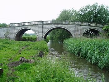
The Grade I listed Blyth New Bridge carries the A634 over the river.
|
|
| Country | England |
| Physical characteristics | |
| Main source | Several streams near Lindrick Common 260 feet (79 m) |
| River mouth | River Idle, Bawtry 10 feet (3.0 m) 53°25′19″N 1°00′44″W / 53.421976°N 1.012153°W |
| Length | 21 miles (34 km) |
| Basin features | |
| Tributaries |
|
The River Ryton is a river in England. It flows into the River Idle. The Ryton starts near Kiveton Park in South Yorkshire. It gets water from several smaller streams near Lindrick Common. Most of the river flows through Nottinghamshire, including the town of Worksop. It then winds its way north to join the River Idle near Bawtry.
Even though much of the river flows through the countryside, its path through Worksop was created by people. This happened because of building projects and old mills. The river used to flow through Scrooby, where there was a mill. But it was moved north in the 1960s. The Ryton also helps supply water to the Chesterfield Canal. Many of the bridges over the river are very old and beautiful. Because of this, they are protected as special buildings.
The water in the River Ryton is okay, but not perfect. A lot of its water comes from treated water from sewage treatment plants. Still, many fish live in the river. People also enjoy fishing there.
Contents
How the River Ryton Gets Its Water
The land under the River Ryton has special rocks that hold water. These are like giant sponges underground. One type is called Magnesian Limestone. It has a mineral called Dolomite, which is rich in Magnesium. Another type is Sherwood Sandstone. These rock layers can give water to the river. They can also take water from it. This depends on how much water people pump out for drinking. It also depends on if the rocks are cracked from coal mining.
The Ryton gets water from several smaller streams. These include Anston Brook, Pudding Dyke, and Bondhay Dyke. Before the Chesterfield Canal was built, Broadbridge Dyke gave more water to the Ryton. But some of its water was moved to fill reservoirs for the canal. Water from these reservoirs can overflow into the Ryton. The river also gives water to the canal through special channels.
The river also gets water from sewage treatment plants. These plants clean water before it goes into the river. For example, plants at Dinnington and Anston add water to Anston Brook. The Kilton Treatment Works also adds water. Sometimes, extra water from the canal flows into the river. Water used to be pumped from a coal mine into the river. Now, water is pumped from the Sherwood Sandstone rock layer into the river. This helps keep the river flowing.
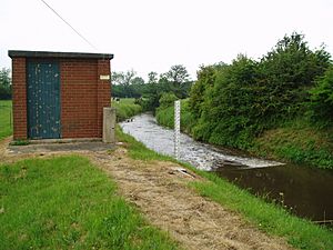
To keep an eye on the river's flow, the Environment Agency has special stations. These stations measure how much water is in the river. One is near Worksop and another is near Blyth. They also have one on Oldcotes Dyke. The amount of water in the river changes. It depends on how much rain falls. For example, the area above Worksop gets about 25.8 inches (655 mm) of rain each year. The highest water levels usually happen during very heavy rain.
The River Ryton's Journey
The River Ryton begins east of Kiveton Park. It starts near the Chesterfield Canal. The Sheffield to Lincoln Railway line crosses the river three times. Then, Pudding Dyke joins the river. The river goes under the railway again. It also goes under a freight train line. At Lindrick Dale, Anston Brook joins the river.
Soon after, a channel called the Brancliffe feeder leaves the river. It carries water to the Chesterfield Canal. The river then crosses under the Sheffield to Lincoln Line again. It also flows under the canal through a special bridge. Then it passes through Shireoaks. The river loops around the village of Rhodesia. It goes under the Worksop to Nottingham railway line. It also passes under the A57 Worksop bypass. Finally, it reaches the western edge of Worksop.
The Ryton in Worksop
For hundreds of years, the river in Worksop was used to power mills. These mills ground grain. In 1636, there were three water mills. They were called Priory Mill and Bracebridge mill. By 1826, these mills had stopped working. But a new mill was built further west. It was called Beard's mill. The mill pond was a busy place. People used it for ice skating in winter. They also fished there. Sometimes, traveling circuses would even bathe their elephants in the pond! The mill building was taken down in 1985. This made way for the Worksop bypass road.
The path of the Ryton through Worksop was mostly made by people. The river used to flow closer to Castle Hill. It might have even been part of the castle's defenses. But in 1842, it was moved into a channel further north. This happened when the Duke of Newcastle built Newcastle Street. He wanted to develop that part of the town.
Now, the river flows underground through a shopping area. This part is like a tunnel. In 2007, experts explored this underground section. They removed about five tons of trash and some stolen items. Beyond Watson Road bridge, there are signs of the old Priory Mill. This mill was used from medieval times until 1876. A large lake called the Canch was formed in 1820. It was created by building a dam. The Canch eventually became dirty. It was filled in when the mill stopped working. The mill buildings were later used to make chairs. They burned down in 1912. Now, the area is a beautiful sensory garden. The river then splits into three channels. These channels go under Priorswell Road. They join up again near the old High Hoe Road bridge.
The Ryton After Worksop
After Worksop, the river flows under the new High Hoe Road bridge. It passes an old pumping station built in 1881. This station used to pump sewage away from Worksop. The river then goes under the Chesterfield Canal again. A higher channel also goes under the canal. It joins the canal near Kilton lock. The river and canal then flow side-by-side. They both pass under a long railway bridge built in 1849.
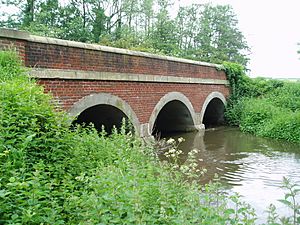
The river then winds through the Osberton Hall estate. It also flows through the village of Scofton. It turns north to go around the western edge of Ranby. Ranby Chequer Bridge is where the river turns northwest. Before this, it mostly flowed east. The next big crossing is the B6045 at Hodsock Red Bridge. This bridge has three arches made of red bricks. After that, an old stone bridge carries the road to Hodsock Priory over the river.
Next, the river goes under the A634 road west of Blyth. The bridge here is very old, built around 1770. It is called Blyth New Bridge. It is a very important historical structure. It is called "New Bridge" to tell it apart from Blyth Old Bridge. That bridge carries the same road over Oldcotes Dyke. Oldcotes Dyke flows from Roche Abbey and joins the Ryton. From here to the River Idle, special groups manage the drainage of the land.
A network of drainage channels follows the river. They go under the A1 road. They collect water from Whitewater Common. They also flow past Serlby and Scrooby. North of Scrooby, the river goes under the A638 Great North Road. It also goes under the road into Scrooby village. And it passes under the East Coast Main Line railway. The Great North Road used to go through Scrooby. But it was rebuilt in 1776 to go around the village. This new road had many brick arches. These arches let the Ryton flow under it, even when there was a flood.
The river used to flow through Scrooby village. It powered Scrooby water mill, which ground corn. The mill stopped working in 1939. The river was moved to its current path in the 1960s. After the railway, there are flood banks on both sides of the river. These banks protect the land from floods. The river then meets the River Idle just before Bawtry bridge. This is as far as boats can travel on the River Idle.
River Water Quality
For fish and other wildlife to live well, the water must be clean. The Environment Agency used to rate rivers from 'A' (best) to 'F' (worst). This was called the General Quality Assessment. They looked at things like ammonia levels and oxygen in the water. These things can be worse when treated sewage water enters the river. They are also often worse in summer. Over time, the water quality has gotten better. This is because of money spent on improving water treatment. Good river flow also helps the water clean itself.
Now, a new system is used to check water quality in England. Each part of a river gets an overall ecological status. This can be high, good, moderate, poor, or bad. To decide this, they look at different things. They check the types and numbers of invertebrates (like insects), plants, and fish. They also check the chemical status. This compares chemical levels to safe limits. Chemical status is either good or fail.
Here is how the River Ryton's water quality was in 2016:
| Section | Ecological Status | Chemical Status | Overall Status |
|---|---|---|---|
| Ryton from Chesterfield Canal to Anston Brook | Good | Good | Good |
| Anston Brook from Source to Ryton | Moderate | Good | Moderate |
| Oldcotes Dyke Catchment | Poor | Good | Poor |
| Ryton from Anston Brook to Idle | Moderate | Good | Moderate |
The quality of Anston Brook has improved since 2009. Back then, its ecological and overall status was rated as poor.
The River Ryton is home to many kinds of fish. In 2006, not many fish lived in the upper parts. This included Anston Brook, because the water quality was only moderate. But several small streams help make the water cleaner. So, wild brown trout live as far down as Worksop. Some trout and different types of carp-like fish live below Worksop. However, sometimes the water levels get very low in summer. This means places where fish lay eggs dry out. It also means young fish lose their homes. This has caused a drop in fish numbers. Still, the lower parts of the river are used for fishing. It is the only place in the River Idle system where people fish in an organized way.
Interesting Places Along the Ryton
| Point | Coordinates (Links to map resources) |
OS Grid Ref | Notes |
|---|---|---|---|
| Source | 53°20′05″N 1°11′28″W / 53.3348°N 1.1910°W | SK539822 | Where Anston Brook and Pudding Dyke join |
| Shireoaks Aqueduct | 53°19′30″N 1°10′30″W / 53.3251°N 1.1749°W | SK550812 | Chesterfield Canal crosses over |
| Bridge Street Culvert | 53°18′19″N 1°07′28″W / 53.3053°N 1.1245°W | SK584790 | Underground section in Worksop |
| Site of Priory Mill | 53°18′16″N 1°07′00″W / 53.3044°N 1.1167°W | SK589789 | Old mill location |
| Kilton Aqueduct | 53°18′15″N 1°06′15″W / 53.3043°N 1.1043°W | SK597789 | Chesterfield Canal crosses |
| Railway viaduct | 53°18′09″N 1°05′11″W / 53.3025°N 1.0863°W | SK609787 | Sheffield to Lincoln Line crosses |
| Chequer Bridge Ranby | 53°19′38″N 1°01′55″W / 53.3271°N 1.0320°W | SK645815 | Bridge near Ranby |
| Hodsock Red Bridge | 53°21′40″N 1°04′00″W / 53.3611°N 1.0668°W | SK622853 | Bridge near Blyth |
| Blyth New Bridge | 53°22′42″N 1°04′25″W / 53.3782°N 1.0737°W | SK617872 | A very old and important bridge |
| Whitewater Common drainage | 53°23′37″N 1°03′22″W / 53.3935°N 1.0560°W | SK628889 | Area with drainage channels |
| Mouth | 53°25′18″N 1°00′44″W / 53.4218°N 1.0121°W | SK657921 | Where the Ryton joins the River Idle |
 | Emma Amos |
 | Edward Mitchell Bannister |
 | Larry D. Alexander |
 | Ernie Barnes |


