
Bawtry facts for kids
Quick facts for kids Bawtry |
|
|---|---|
| Town | |
 Shops on the High Street |
|
 St Nicholas' Church, Bawtry |
|

Bawtry
|
|
| Population | 3,573 (2011 census) |
| OS grid reference | SK6593 |
| Civil parish |
|
| Metropolitan borough |
|
| Metropolitan county | |
| Region | |
| Country | England |
| Sovereign state | United Kingdom |
| Post town | Doncaster |
| Postcode district | DN10 |
| Dialling code | 01302 |
| Police | South Yorkshire |
| Fire | South Yorkshire |
| Ambulance | Yorkshire |
| EU Parliament | Yorkshire and the Humber |
| UK Parliament |
|

Bawtry is a small and historic market town in South Yorkshire, England. It is part of the City of Doncaster. The town is about 8 miles (13 km) south-east of Doncaster. It sits near the borders of Nottinghamshire and Lincolnshire.
Bawtry was once divided between two historic areas: the West Riding of Yorkshire and Nottinghamshire. In 2011, about 3,573 people lived here. Nearby places include Austerfield, Everton, and Scrooby.
Contents
Discovering Bawtry's Past

The name "Bawtry" might come from old English words. It could mean "place at a ball-shaped tree." The town was not mentioned in the Domesday Book. But it appeared as Baltry in 1199.
Bawtry was first a Roman settlement. It was on Ermine Street, a major Roman road. This road connected Doncaster and Lincoln. In 616 AD, King Aethelfrith died in a battle nearby.
From Village to Busy Port
A small village grew here during the Danelaw period. This was when Vikings ruled parts of England. People believe St Nicholas's Church was built around this time. The village was first in Nottinghamshire. But its borders changed, placing it in the West Riding of Yorkshire.
Around the year 1200, a new town started next to the old village. A man named Robert de Vipont helped create it. In 1213, he received a special permission from the king. This allowed Bawtry to hold a four-day fair each year. A market was first noted in 1247.
The town became important as a river port. It was also a busy stop for travelers between Doncaster and Retford. By the mid-1300s, Bawtry was exporting wool overseas.
Later Years and Modern Times

Later, trade in Bawtry slowed down. But it grew again in the Elizabethan period. This was thanks to shipping millstones.
During and after World War II, Bawtry Hall was very important. It was the main base for RAF No.1 Group Bomber Command. Later, it became the headquarters for RAF Strike Command.
Bawtry's Location

Bawtry is where the Roman Ermine Street crosses the River Idle. It is on the A638 road, which used to be the famous Great North Road.
The town is just south of Doncaster Sheffield Airport. This airport used to be RAF Finningley. Bawtry is also where three main roads meet: the A614, A631, and A638.
For many years, Bawtry was a traffic jam spot. A bypass road was finally built in 1965. The border with Nottinghamshire is just south of the town. One house on the old Great North Road even calls itself "Number One Yorkshire."
Bawtry's success came from its good connections. First, it was a port on the River Idle. Then, it was a key stop on the Great North Road. Later, the Great Northern Railway helped it grow.
Local Media and News
People in Bawtry get their local news and TV from BBC Yorkshire and ITV Yorkshire. Radio stations like BBC Radio Sheffield and Heart Yorkshire are also available. The local newspaper is the Doncaster Free Press.
Community Life in Bawtry
Bawtry has a school called Bawtry Mayflower School. It is named after the ship Mayflower. This ship carried William Bradford, a leader of the Pilgrims, to America. Bradford came from Austerfield, which is very close to Bawtry.
The White Hart is the oldest pub in town, built in 1689. The Crown Hotel was once a place where horse-drawn coaches would stop. Famous people like singer Ronan Keating have stayed there.
South Parade has many beautiful Georgian houses. The Courtyard is a newer area with homes, shops, and businesses. It even won an award in 2005 for its design.
Bawtry Hall used to be a Christian conference center. Now, it hosts many different events, like wedding receptions.
Famous People from Bawtry
- George Morton (1585–1624), a Pilgrim Father who helped publish an important book about the first American colony.
Images for kids
-
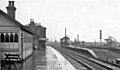
The former railway station during its heyday

See also
 In Spanish: Bawtry para niños
