
River Idle facts for kids
Quick facts for kids River Idle |
|
|---|---|

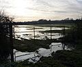
The road bridge and sluice gate at the junction with the River Trent
|
|
.png) |
|
| Country | England |
| Physical characteristics | |
| Main source | Confluence of River Maun and River Meden 59 feet (18 m) |
| River mouth | River Trent 0 ft (0 m) |
| Length | 26 miles (42 km) |
| Basin features | |
| Tributaries |
|
The River Idle is a river in Nottinghamshire, England. It starts where two other rivers, the River Maun and the River Meden, meet near Markham Moor. From there, it flows north through towns like Retford and Bawtry. Finally, it joins the River Trent at Stockwith, close to Misterton.
For a short distance, the river forms part of the border with South Yorkshire near Bawtry. It also marks the border with Lincolnshire at a place called Idle Stop. A long time ago, in 1628, engineers changed the river's path. They moved it eastwards to help drain the land.
Most of the land around the River Idle is a wide, flat area called a flood plain. This area can get flooded when the river is very full. Between Retford and Bawtry, some parts of the flood plain have old sand and gravel pits. These are now public lakes where people can go fishing.
Beyond Bawtry, the river has high banks to stop it from flooding. This helps to keep the low-lying farmland dry. The main rivers that flow into the Idle are the River Poulter and the River Ryton.
You can travel by boat on the River Idle up to Bawtry. There's even a legal right to travel further upstream to East Retford. However, getting onto the river through the special gates (sluices) can be very expensive. The Environment Agency looks after the river for drainage. The river is also important for nature. Some areas, like the Idle Washlands and the sand and gravel pits, are special protected sites for wildlife.
Contents
River Water Quality
The Environment Agency checks the water quality of rivers in England. They use a system to rate how healthy the water is. This rating looks at things like tiny creatures (invertebrates), plants, and fish in the water. They also check for different chemicals.
The water quality of the River Idle system was rated in 2016. Most parts of the river were given a 'moderate' rating for their overall health. This means the water is okay, but not as good as it could be.
The chemical status of the water was rated 'good'. This means the levels of chemicals in the water are safe. However, the overall health is still 'moderate'. This is because of things like sewage being released into the river. Also, water is taken from the ground, and farming practices can affect the river.
A Look Back at the River's Past

The River Idle has a long history! In the 7th century, a big battle happened here. King Rædwald of East Anglia and his army beat the Northumbrians. This story was written down in a book called Historia Anglorum in the 12th century.
Before the 1600s, the river flowed north from a spot now called 'Idle Stop'. It joined another river, the River Don. But in 1626, a Dutch engineer named Cornelius Vermuyden was hired by King Charles I. His job was to drain a large area called Hatfield Chase.
Vermuyden and his team finished the work in just two years. They built a dam at Idle Stop. This changed the Idle's path. Its water was sent along an old Roman channel called Bycarrs Dyke. This channel then joined the River Trent. A special gate (sluice) was built near Misterton Soss. This gate stopped water from the Trent from flooding the land.
People were not happy with these changes. They felt the drainage work caused problems and flooding. During the English Civil War, some parts of the drainage system were damaged. People broke down the sluice gates, causing big floods. There were many arguments and even fights for years. Finally, in 1719, things settled down.
In the early 1700s, a writer named Daniel Defoe visited the river. He said it was "full and quick" and had a "deep channel." He described Bawtry as an important port. Goods like lead, iron, and coal were brought there. Then they were shipped out on boats.
In 1720, merchants from East Retford wanted to extend the river for boats. They got a special law passed to do this. But the work never happened. By then, much of the river's trade had moved to other waterways.
Boats using the river were usually shallow. They were about 48 by 14 feet (14.6 by 4.3 m) and could carry 12 to 24 tons of goods. By 1828, most commercial boats had stopped using the river. A new railway line was built, which also affected the river's use.
River Management Over Time
The Hatfield Chase Company looked after the river below Idle Stop until 1930. Then, the Land Drainage Act 1930 changed things. Control went to the Trent River Catchment Board. They built a new gate (sluice) at the mouth of the Idle.
Later, the Trent River Authority took over. They did some dredging to make the river deeper. In 1963, the old sluice at Misterton Soss was removed. This made it harder for boats to use the river.
In the 1970s, there were plans to remove navigation rights on the river. But groups like the Inland Waterways Association fought against this. They wanted to keep the river open for boats. So, the plans to remove navigation rights were dropped.
The government also decided that water authorities should help develop fun activities on rivers. This meant the plans for a pumping station were put on hold. Boat clubs started organizing trips on the river every year.
In 1981, a new pumping station and a second sluice were built. These helped control the river's water level. The river was also dredged to make it deeper, about 5 feet (1.5 m) deep up to Bawtry. This made it much easier for boats to travel.
Today, the Environment Agency looks after the river. They say there is a legal right for boats to travel from the Trent to Bawtry. There's even a right to go further upstream to East Retford, even though that part was never improved. However, you need to give 48 hours' notice to enter or leave the river. Also, the charges to use the sluice gates are very high, making it expensive for single boats.
How the River is Drained
The banks of the River Idle below Bawtry have been made higher. This helps the river carry water away from the surrounding land. The area around the river has many drainage ditches. These ditches are connected to the river by gates (sluices) and pumping stations.
Water is pumped from the ditches to stop farmland from flooding. Sometimes, a pumping station can even send water back into the ditches to help water crops. The water flowing into the River Trent is controlled by a pumping station and two sluices. When the Trent's water level is low, the gates open, and water flows out by itself. But when the Trent is high, big electric pumps push the water out. The pumping station built in 1981 was the largest of its kind in Britain at the time.
A large drainage ditch called the Mother Drain runs next to the lower river for about 10 miles (16 km). This ditch was built between 1796 and 1801 to collect water from the low-lying land. Old steam-powered pumping stations, named Kate and Ada, used to pump water from the Mother Drain into the river. These were some of the first steam engines used for draining land outside of the Fens. These old buildings are now protected as historic sites.
Different groups called Internal Drainage Boards (IDBs) manage the drainage in specific areas. For example, the Everton IDB looks after watercourses south of the Mother Drain. The Finningley IDB manages drainage on the north side of the river. These boards work to keep the land from flooding.
Recently, many of these smaller drainage boards have joined together. This helps them work more efficiently and better manage flood protection.
Boating on the River Idle

You can travel by boat on the River Idle for about 11 miles (18 km) from West Stockwith to Bawtry. Bawtry might have been a seaport even in Roman times! Records show lead and wool were shipped from here in the 1300s.
After a special gate (lock) was built in the 1600s, boats had to be smaller. Their goods were then moved to bigger ships on the Trent. When the drainage works were damaged in 1643, larger ships could reach Bawtry again.
By the late 1700s, trade on the river started to decline. The opening of the Chesterfield Canal and later the Great Northern Railway meant most goods were moved in other ways. Commercial boating on the river almost stopped.
Today, to get onto the Idle, you go through two sluice gates at the river's mouth. The Environment Agency manages this. You need to tell them 48 hours before you want to enter. The cost to pass through the gates is high, so most boaters go in groups to share the cost. The space between the two gates acts like a very big lock, holding many boats at once.
Boats can reach Bawtry bridge. There are limits on boat size: about 59.7 by 18 feet (18.2 by 5.5 m), with a depth of 2.5 feet (0.76 m) and height of 9 feet (2.7 m). There are no public places to tie up your boat. Large boats can turn around near Bawtry bridge and where the River Ryton joins the Idle.
Above Bawtry, smaller boats like canoes can travel all the way from the river's start. You can get onto the river from a bridge over the River Meden, just above where it meets the River Maun.
The River Idle also provides water for the Chesterfield Canal. An electric pumping station now sends water from the river to the canal.
Protecting Nature on the Idle
The River Idle is important for nature and wildlife. There are four areas of grassland next to the lower river that often flood. These areas are called the Idle Washlands and are a Site of Special Scientific Interest (SSSI). They are a great home for birds in winter and for breeding.
A long time ago, a much bigger area would have flooded naturally. But flood defences have reduced this space. Work is being done to make sure these important bird habitats are not lost. The Environment Agency has a plan to manage water levels to protect these sites. Parts of the Mother Drain are also protected as an SSSI.
Further upstream, the Sutton and Lound gravel pits are also an SSSI. This area used to be a quarry where sand and gravel were dug out. Now, it's a huge nature reserve managed by the Nottinghamshire Wildlife Trust. It's one of the biggest nature sites in the East Midlands.
These pits create an important wetland home for many different birds. Over 170 bird species have been seen here, including some that usually live near the coast! The reserve also has many insects, like moths, butterflies, and dragonflies.
The River's Path
The River Idle mostly flows through the countryside. But it does go through the middle of Retford and past the edge of Bawtry. The village of Eaton, near Retford, is thought to be where a battle happened in 616. In this battle, King Raedwald of the East Angles defeated the Northumbrians.
Bawtry bridge carries the A631 road over the river. It was built in 1810 and cost £3,000. It has a large arch in the middle and two smaller arches on the sides. The road was made wider in 1940, but the bridge still looks much like it did originally.
| Point | Coordinates (Links to map resources) |
OS Grid Ref | Notes |
|---|---|---|---|
| Source | 53°16′06″N 0°56′53″W / 53.2684°N 0.9480°W | SK702751 | Rivers Meden and Maun join |
| Retford Aqueduct | 53°19′09″N 0°56′48″W / 53.3192°N 0.9466°W | SK702807 | Chesterfield Canal crosses |
| Sutton Weir | 53°20′35″N 0°57′40″W / 53.3430°N 0.961°W | SK692834 | |
| Wiseton pumping stn | 53°23′47″N 0°55′55″W / 53.3965°N 0.9320°W | SK711893 | Idle and Ryton IDB |
| Bawtry Bridge | 53°25′36″N 1°00′51″W / 53.4268°N 1.0143°W | SK655926 | Limit of navigation |
| Austerfield pumping stn | 53°26′22″N 0°59′53″W / 53.4394°N 0.9981°W | SK666940 | Finningley IDB |
| Scaftworth pumping stn | 53°26′11″N 0°59′34″W / 53.4363°N 0.9929°W | SK670937 | Everton IDB |
| Gringley pumping stn | 53°26′46″N 0°55′43″W / 53.4461°N 0.9285°W | SK712949 | Everton IDB |
| Idle Stop and PS | 53°27′39″N 0°54′54″W / 53.4609°N 0.9149°W | SK721965 | Former course turned north |
| Hunters Hill pumping stn | 53°27′36″N 0°51′38″W / 53.4599°N 0.8606°W | SK757965 | Finningley IDB |
| Misterton Soss | 53°26′50″N 0°49′46″W / 53.4472°N 0.8295°W | SK778951 | Former pumping stns |
| Outlet pumping stn | 53°26′45″N 0°48′59″W / 53.4457°N 0.8165°W | SK787949 | inc. navigable sluice |
| Entrance sluice | 53°26′37″N 0°48′46″W / 53.4436°N 0.8127°W | SK789947 | vertical lifting gate |
Images for kids
-
Flooded and frozen fields near Grove Lane

