River Meden facts for kids
Quick facts for kids River Meden |
|
|---|---|

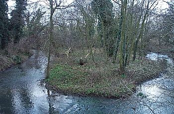
River at Burns Lane in Warsop.
|
|
| Country | England |
| County | Nottinghamshire |
| Physical characteristics | |
| Main source | Huthwaite |
| River mouth | River Idle Markham Moor 53°16′6″N 0°56′52″W / 53.26833°N 0.94778°W |
| Basin features | |
| Tributaries |
|
The River Meden is a river located in Nottinghamshire, England. It starts near Huthwaite, close to the Derbyshire border. From there, it flows northeast through places like Pleasley and Warsop. Eventually, it joins with the River Maun near Bothamsall. After flowing together for a short distance, they split up again. Finally, near Markham Moor, they combine once more to form the River Idle.
For many years, the River Meden was an important source of power for mills. These mills, especially in Pleasley Vale, used the river's water to run their machines. This continued from the 1760s all the way until the 1980s. Today, the old mill buildings are used for different types of light industry.
Contents
The River's Journey
The River Meden begins as two small streams north of Huthwaite. These streams are found on the higher ground, about 200 feet (61 meters) above sea level. They flow northeast, passing by Stanton Hill and Skegby. Another stream joins the river from the Car Ponds, which are near the Hardwick Hall estate.
The river then flows along the border between Nottinghamshire and Derbyshire. It goes south of Pleasley and under the A617 road. Before the bridge, there are two large ponds. The second pond is held back by an old dam, built in 1800. The river then enters Pleasley Vale. Here, the water has carved a deep, narrow valley through the rock. This area is very pretty and has many trees.
Pleasley Vale and Its Mills
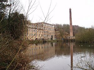
In Pleasley Vale, you can still see several old mill buildings. These were built from local limestone. Two large mill ponds remain, along with two main mill buildings. Another building is on a smaller stream that joins the Meden here.
After Pleasley Vale, the river flows under the Robin Hood Line railway. It continues northeast and is joined by a stream called The Bottoms. This stream starts in Mansfield Woodhouse and flows north. Further along, the river is also joined by Sookholme Brook.
Warsop and Thoresby Park
The River Meden flows between Church Warsop and Market Warsop. Here, it goes under the A60 road. Just below this bridge is the old Warsop watermill. Much of this mill dates back to 1767. It still has some of its original machinery inside.
The river then turns east and flows through Budby. It enters Thoresby Park, where it has been dammed to create a large, beautiful lake called Thoresby Lake. In 1941, the owner of Thoresby Hall used the height difference at the end of the lake to install two water turbines. These turbines generated electricity for the hall.
Joining Other Rivers
Below Thoresby Lake, the river passes the small village of Perlethorpe. Here, it is joined by the River Maun, which flows north and is sometimes called Whitewater in this area. The Robin Hood Way, a long walking path, crosses the rivers soon after. A weir then splits the combined flow into two channels again. The southern channel is considered the Maun, and the northern one is the Meden.
These two rivers flow roughly side-by-side. They pass under the B6387 road near Bothamsall and a freight railway line. They then separate west of the Markham Moor roundabout on the A1 road. After passing under the A1, they combine to officially form the River Idle. Just after this junction, the River Poulter also adds its water to the flow.
The Mills of River Meden
The River Meden has been used for power since at least 1767. Back then, there were two forges (places where metal is shaped) and a corn mill operating near Pleasley Vale. The river's path was changed to make it even better for building more mills.
Early Cotton Mills
In 1782, a group of business people decided to build water-powered cotton mills in Pleasley Vale. The first mill, called the Upper Mill (now Mill 1), was built on the site of the old corn mill and started working by 1785. The Lower Mill (now Mill 3) was finished seven years later and was much bigger. Houses for the workers and a manager's house were also built. These mills made cotton for the growing clothing industry in the East Midlands.
The Hollins family became very important in running these mills. By the early 1800s, William Hollins and Co. was in charge. They were among the first and most successful cotton makers in the East Midlands.
Growth and Community Life
The Hollins family managed the mills for many years. In the 1830s, the Paget family joined them and introduced steam power to the mills. Sadly, the Upper Mill burned down in 1840 but was rebuilt by 1844. The Lower Mill also burned down and was replaced in 1847. New machines helped the mills stay competitive.
William Hollins lived in Pleasley Vale and helped the community grow. More houses were built for workers, and public services were added. These included a school, a wash house, and a cooperative society (a shop owned by its members). They also focused on fun activities, setting up a Mechanics Institute (a place for learning), a library, and a cricket club. There was even a company farm.
In 1876, Charles Paget ordered the building of St Chad's Chapel and the vicarage. The chapel opened in 1881. It has a small bell tower and looks like churches from the 1200s and 1300s. Inside, there is a special brass memorial for Paget and his wife.
Later Years and Modern Use
From the 1890s, the mills started making Viyella. This is a soft fabric made from a mix of cotton and Merino wool. The mills continued to expand. The Upper Mill had an extra floor added in the 1890s and more extensions around 1913. A large combing shed, where cotton fibers were straightened, was built in 1913. This shed was later expanded and became Mill 2. The Lower Mill was also extended, but it still looks much like it did when it was first built.
In 1934, about 980 people worked at the mills. However, over time, the business started to decline. Some of the first workers' houses were taken down in 1961, followed by the school and other buildings. By 1987, production had moved to other countries, and the mills closed.
In 1992, Bolsover District Council bought the mill buildings. They have been brought back to life and are now used for light industry and offices. The mill ponds are still there too.
River Health: Water Quality
The Environment Agency checks the water quality of rivers in England. They give each river system an overall "ecological status." This status can be high, good, moderate, poor, or bad. To figure this out, they look at things like the types and numbers of invertebrates (small creatures without backbones), plants, and fish in the water. They also check the "chemical status," which compares the levels of different chemicals to safe limits. Chemical status is either good or fail.
Here's how the water quality of the River Meden and its smaller streams was in 2015:
| Section | Ecological Status | Chemical Status | Overall Status | Length | Catchment |
|---|---|---|---|---|---|
| Meden from Source to Sookholme Brook | Moderate | Good | Moderate | 14.8 miles (23.8 km) | 20.25 square miles (52.4 km2) |
| Sookholme Brook Catchment (trib of Meden) | Poor | Good | Poor | 2.3 miles (3.7 km) | 4.09 square miles (10.6 km2) |
| Meden from Sookholme Brook to Maun | Moderate | Good | Moderate | 9.2 miles (14.8 km) | 16.06 square miles (41.6 km2) |
The water quality in the lower part of the River Meden has gotten better. In 2009, its ecological and overall status was "poor," but it improved to "moderate." However, Sookholme Brook's quality has gotten worse, as it was "moderate" in 2009.
Places to See Along the Meden
| Point | Coordinates (Links to map resources) |
OS Grid Ref | Notes |
|---|---|---|---|
| Meden and Maun form Idle | 53°16′07″N 0°56′52″W / 53.2685°N 0.9478°W | SK702751 | mouth |
| Meden and Maun join and split | 53°14′28″N 1°00′51″W / 53.2410°N 1.0143°W | SK658720 | |
| Thoresby Lake | 53°13′43″N 1°02′59″W / 53.2287°N 1.0496°W | SK635706 | |
| A60 bridge, Church Warsop | 53°12′40″N 1°08′59″W / 53.2111°N 1.1497°W | SK568685 | |
| Robin Hood Line bridge | 53°10′56″N 1°12′15″W / 53.1823°N 1.2043°W | SK532653 | |
| Pleasley Vale and Mills | 53°10′45″N 1°13′34″W / 53.1792°N 1.2261°W | SK518649 | |
| Springs | 53°08′30″N 1°18′26″W / 53.1417°N 1.3072°W | SK464607 | source |
| Springs | 53°08′08″N 1°16′22″W / 53.1355°N 1.2728°W | SK487600 | source |
 | Delilah Pierce |
 | Gordon Parks |
 | Augusta Savage |
 | Charles Ethan Porter |


