
River Poulter facts for kids
Quick facts for kids River Poulter |
|
|---|---|

The ford at Crookford, where a track crosses the Poulter
|
|
| Country | England |
| County | Nottinghamshire |
| Physical characteristics | |
| Main source | Scarcliffe |
| River mouth | River Idle Elkesley |
The River Poulter is a river in England. It starts near Scarcliffe in Derbyshire and flows into the River Idle in Nottinghamshire. Long ago, the river's power helped run many mills. Most of these mills are gone now, but their ponds remain. One old mill building at Cuckney is even a primary school today!
The river also feeds several beautiful lakes in the Dukeries area. These include lakes on the Welbeck Abbey estate and at Clumber Park, which is now looked after by the National Trust. The water quality of the River Poulter is very good. This means it's a great home for fish and many different kinds of birds.
Contents
The River Poulter's Journey
The River Poulter begins as a spring near Scarcliffe in Derbyshire. It flows northeast, passing by the village of Nether Langwith. Along its way, it goes under an old railway track. A stream called Owl Sick joins the Poulter near Langwith. This stream starts at Owl Spring in Scarcliffe Park.
From Colliery to Country Park
Another stream flows through the Poulter Country Park. This park used to be a waste tip for Langwith Colliery, a coal mine. The mine closed in 1978. By 1987, most of the site was cleaned up. In 1988, the waste tips were turned into the country park we see today.
Mills and Viaducts Along the Way
The streams flow into a millpond that once powered Scarcliffe Mill. This mill was very old, mentioned in records from 1432. The last mill here was taken down in the 1960s. Below the old mill, the river flows through an arch of a two-arch viaduct. This bridge was built in the 1870s for the Midland Railway. Today, the Robin Hood Line uses this railway for trains from Worksop to Nottingham.
As the river passes through Langwith, it splits into two channels. These channels go around some houses and then join up again. A stone sign here shows where a sheep dip was located in 1896. Further on, the river flows into "The Lake," which covers about 5.4 acres.
Langwith Mill House and Cuckney School
Langwith Mill House is where a large cotton mill was built in 1786. It was one of the biggest in the area. The mill closed in 1848 and later became a corn mill. The building is quite old and needs repair.
The river then splits again. One channel goes down, while the other stays level to supply water to two mills at Cuckney. There have been mills here for hundreds of years. A lake called Cuckney Dam, covering 8.2 acres, provided water for the mill. This mill stopped working in 1844. The Duke of Portland then turned the building into a school. Today, it is part of Cuckney Primary School. The school even uses the river to make its own electricity with a special turbine!
After Cuckney, the river reaches the site of another old corn mill. The mill is gone, but you can still see the sluices and weir that controlled the water.
Welbeck Lakes: A Grand Estate
Beyond the mill site, the river splits into two channels again. Both channels flow towards the first beautiful lake on the Welbeck estate. This estate was once owned by the Dukes of Portland. Millwood Brook also flows into Gouldsmeadow Lake and Shrubbery Lake, which then join the Great Lake.
In the 1760s, a famous engineer named Robert Mylne tried to build a three-arch bridge here. But the bridge had problems and part of it collapsed. Later, in the 1840s, another duke hired engineer William Tierney Clark to build a suspension bridge. The western channel of the Poulter flows into the Great Lake. The lower eastern channel flows into Carburton Forge Dam.
Carburton Forge and Dam
Beyond the Great Lake, a weir drops the water level to Carburton Forge Dam. This dam was built to power a forge, which is a place where metal is shaped using heat. In 1695, land was leased to John Wheeler, who built the forge. The forge was busy until the 1770s. The fifth duke later removed all signs of the forge.
After Carburton Forge Dam, another weir drops the water level to Carburton Dam. An old lease from 1678 mentions a "water corn mill" here. The five Welbeck lakes together cover a large area of 151 acres.
Below the lake, there are two channels again. The main southern channel is lower than the northern one, which is called the Flood Dyke. Both channels pass under the B6034 road. The land between these channels is sandy. The Flood Dyke was used to water the land, creating water meadows. In 2010/11, old structures like sluices and valves were fixed up to help visitors understand how this system worked.
Clumber Lake: A National Trust Gem
Both channels pass under the road in the small village of Carburton. The upper channel, Flood Dyke, eventually joins the lower channel. The lower channel then flows under Carburton bridge to supply Clumber Lake. This lake is part of the Clumber estate, which has been owned by the National Trust since 1945.
In the 18th century, the Clumber estate was described as a "black heath full of rabbits." In 1772, the second Duke of Newcastle started building Clumber Lake. He built a dam and dug out the river bed to create a wide lake. A beautiful ornamental bridge was built at the western end. This project took 15 years and cost a lot of money! The bridge is 230 feet long and has three arches. It is a Grade II* listed structure, meaning it's very important historically.
Improvements were made to the lake in 1786. In 1823 and 1835, the 4th Duke of Newcastle built cascades, which are like small waterfalls, below the bridge. The lake has been affected by the ground sinking due to coal mining. Work was done in the 1980s and 2004 to fix this. When the water level was lowered for this work, the burnt remains of a one-third scale naval ship called the Lincoln were found. The duke bought this ship in 1871, and it was destroyed by fire in the 1940s.
The river leaves Clumber Lake by a weir and cascade near Hardwick village. It then passes under West Bridge on the A614 road. Most of the rest of the river's journey is through woodland. A ford crosses the river near Crookford farm. The river is also crossed by the B6387 road and the A1 road near Gamston Airport. Finally, it joins the River Idle.
River Health: How Clean is the Poulter?
The River Poulter starts in an area with a special type of rock called Magnesian Limestone. This rock holds a lot of water. Where this rock comes to the surface, springs often appear, and that's how the Poulter begins. The water quality of the River Poulter is very good. The Environment Agency, which checks river health, uses a rating scale from 'A' (best) to 'F' (worst). The upper part of the Poulter is rated 'B'. This is good, even though some treated water from Langwith Sewage Treatment Works flows into it.
Water Quality Measures
Water quality is measured by several things:
- Ammonia levels: How much ammonia is in the water.
- Dissolved oxygen: How much oxygen is in the water for fish and other creatures to breathe.
- Biochemical oxygen demand (BOD): How much oxygen is needed by tiny organisms to break down stuff in the water.
These factors are usually worse when water from sewage treatment plants enters the river. They can also be worse in summer.
The water quality stays good throughout the river. In the final section before it joins the River Idle, the levels of ammonia and dissolved oxygen are what you would expect in a natural, healthy river. Levels of phosphates and nitrates, which can come from farms, are a bit high, but they have improved.
Biological Health of the River
Scientists also check the river's health by looking at the living things in it.
- NTAXA: This counts the total number of different invertebrate species found in the water.
- ASPT: This is a score based on how sensitive different invertebrates are to pollution.
From 2004 to 2006, the final section of the river got an 'A' (very good) for NTAXA and a 'B' (good) for ASPT. This means the water is very close to being completely unpolluted!
The Environment Agency now uses a new system to rate rivers. They give an overall ecological status: high, good, moderate, poor, or bad. This looks at the amount and types of invertebrates, plants, and fish. They also check chemical status, which is rated good or fail.
In 2015, the Poulter's water quality was rated as 'moderate' for ecological status and 'good' for chemical status for most sections.
River Life: Plants and Animals
The upper parts of the River Poulter are very important for nature. They have areas of wet woodland, which are rich homes for many different species. The good water quality means that various fish species can live here. The river above Welbeck Lake is home to a good number of wild brown trout.
The large lakes make the water move slowly. This slow water is perfect for fish like carp, pike, and eels. The lower parts of the river are also used by fish from the River Idle to lay their eggs.
Birds of the Lakes
The lakes are also home to many birds. Clumber Lake has alder, sallow, and ash trees along its edges. It also has some sedge marsh. Clumber Lake was one of the first places in the country where gadwall ducks bred. It also has a winter population of goosander ducks.
Hobbys, which are small falcons, often visit the reed beds below Clumber Dam in August and September. They hunt swallows and martins there. The upper lake has oak, yew, beech, and Scots pine trees. It is home to willow tits and woodpeckers. Blackcaps visit in the summer, and Mandarin ducks sometimes stop by too.
Images for kids
-
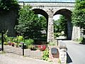
The Langwith Viaduct carries the Robin Hood Line over the river at Langwith. Through the arch is the old pumphouse, which once supplied water to Langwith Colliery.
-
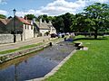
The river at Langwith


| Point | Coordinates (Links to map resources) |
OS Grid Ref | Notes |
|---|---|---|---|
| Source | 53°12′35″N 1°16′14″W / 53.2097°N 1.2705°W | SK488683 | Spring near Scarcliffe |
| Langwith Viaduct | 53°13′36″N 1°12′41″W / 53.2268°N 1.2113°W | SK527702 | site of Scarcliffe mill |
| Langwith mill | 53°13′39″N 1°10′56″W / 53.2274°N 1.1821°W | SK547703 | |
| Cuckney School | 53°14′00″N 1°09′44″W / 53.2332°N 1.1621°W | SK560710 | Former mill |
| Welbeck Great Lake | 53°14′44″N 1°07′49″W / 53.2455°N 1.1303°W | SK581724 | weir |
| Carburton Dam | 53°14′45″N 1°06′06″W / 53.2458°N 1.1017°W | SK600724 | sluice |
| Clumber bridge | 53°15′28″N 1°04′15″W / 53.2578°N 1.0708°W | SK620738 | |
| Hardwick ford | 53°16′11″N 1°02′23″W / 53.2698°N 1.0396°W | SK641751 | |
| Crookford | 53°16′11″N 0°59′41″W / 53.2697°N 0.9946°W | SK671752 | |
| Mouth | 53°16′16″N 0°57′02″W / 53.2710°N 0.9505°W | SK700754 | Jn with River Idle |
