Olean, Missouri facts for kids
Olean is a small town located in northern Miller County, Missouri, in the United States. In 2020, about 114 people lived there.
Quick facts for kids
Olean, Missouri
|
|
|---|---|

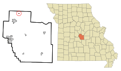
Location in Miller County and the state of Missouri
|
|
| Country | United States |
| State | Missouri |
| County | Miller |
| Area | |
| • Total | 0.17 sq mi (0.45 km2) |
| • Land | 0.17 sq mi (0.45 km2) |
| • Water | 0.00 sq mi (0.00 km2) |
| Elevation | 781 ft (238 m) |
| Population
(2020)
|
|
| • Total | 114 |
| • Density | 658.96/sq mi (254.58/km2) |
| Time zone | UTC-6 (Central (CST)) |
| • Summer (DST) | UTC-5 (CDT) |
| ZIP code |
65064
|
| Area code(s) | 573 |
| FIPS code | 29-54560 |
| GNIS feature ID | 2396832 |
Contents
History of Olean
The town of Olean was started between 1881 and 1882. It was founded by a railroad company that later became the Missouri Pacific Railroad.
How Olean Got Its Name
The town had a few different names before it became Olean. First, it was called Proctor, after an early settler named James G. Proctor. But there was already another town named Procter in Missouri, so they had to change it.
Next, they tried the name Cove because the town had a semicircular shape, like a cove. This name was also rejected because it was too similar to another place in the state. Then, Chester was suggested, but it was also turned down because there was another Chester along the same rail line.
Finally, the railroad company decided on the name "Olean." They named it after Olean, New York. No one knows exactly why they picked this name, as the Missouri town had no connection to the New York city or to oil.
Early Businesses and the Railroad
Around the year 1900, Olean had a gristmill, which grinds grain into flour, and a canning factory. These businesses helped the town grow.
The railroad stopped serving Olean in 1962. However, the old train station, known as the Olean Railroad Depot, is still important. It was added to the National Register of Historic Places in 1993 because of its historical value.
Geography of Olean
According to the United States Census Bureau, Olean covers a total area of about 0.17 square miles (0.45 square kilometers). All of this area is land.
Population and People
| Historical population | |||
|---|---|---|---|
| Census | Pop. | %± | |
| 1900 | 254 | — | |
| 1910 | 214 | −15.7% | |
| 1920 | 169 | −21.0% | |
| 1930 | 160 | −5.3% | |
| 1940 | 151 | −5.6% | |
| 1950 | 165 | 9.3% | |
| 1960 | 135 | −18.2% | |
| 1970 | 151 | 11.9% | |
| 1980 | 128 | −15.2% | |
| 1990 | 106 | −17.2% | |
| 2000 | 157 | 48.1% | |
| 2010 | 128 | −18.5% | |
| 2020 | 114 | −10.9% | |
| U.S. Decennial Census | |||
Olean's Population in 2010
In 2010, the census showed that 128 people lived in Olean. The town had 57 households. The population density was about 753 people per square mile (291 people per square kilometer).
Most of the people living in Olean were White (90.6%). A smaller number were African American (5.5%), and 3.9% were from two or more races. About 3.1% of the population identified as Hispanic or Latino.
The average age of people in Olean was 42.5 years. About 21.1% of residents were under 18 years old. About 8.6% were between 18 and 24 years old. Most residents, 35.9%, were between 45 and 64 years old. The population was almost evenly split between males (53.1%) and females (46.9%).
See also
 In Spanish: Olean (Misuri) para niños

