
Omar, West Virginia facts for kids
Quick facts for kids
Omar, West Virginia
|
|
|---|---|

Omar
|
|

Omar, West Virginia
Location in West Virginia

Omar, West Virginia
Location in the United States
|
|
| Country | United States |
| State | West Virginia |
| County | Logan |
| Area | |
| • Total | 1.140 sq mi (2.95 km2) |
| • Land | 1.125 sq mi (2.91 km2) |
| • Water | 0.015 sq mi (0.04 km2) |
| Elevation | 814 ft (248 m) |
| Population
(2010)
|
|
| • Total | 552 |
| • Density | 490.7/sq mi (189.5/km2) |
| Time zone | UTC-5 (Eastern (EST)) |
| • Summer (DST) | UTC-4 (EDT) |
| ZIP code |
25638
|
| Area code(s) | 304 & 681 |
| GNIS feature ID | 1544403 |
| FIPS code | 54-60628 |
Omar is a small community located in Logan County, West Virginia, in the United States. It is known as an unincorporated community, which means it doesn't have its own local government like a city or town does. Instead, it's managed by the county. Omar is also a census-designated place (CDP). This means the United States Census Bureau has defined it as a specific area for gathering population data.
In 2010, the population of Omar was 552 people. It is situated along West Virginia Route 44 and a stream called Island Creek. Omar is about 6.5 miles (10.5 km) south of a larger town named Logan. The community has its own post office with the ZIP code 25638.
How Omar Got Its Name
The community of Omar was named after a person! It got its name from James Omar Cole. He was one of the people who originally leased land in the area.
Life in a Coal Town
Omar is considered a "coal town" because it was historically important for coal mining. Many communities in West Virginia grew up around coal mines, where people worked to dig coal out of the ground. These towns often had homes, stores, and services built to support the miners and their families.
Images for kids
-
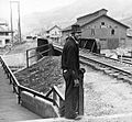
Omar in 1935
.jpg)
See also
In Spanish: Omar (Virginia Occidental) para niños
