
Urozgan Province facts for kids
Quick facts for kids Urozgan (اروزگان) |
|
| Province | |
 |
|
| Country | Afghanistan |
|---|---|
| Capital | Tarinkot |
| - coordinates | 32°48′N 66°00′E / 32.8°N 66.0°E |
| Area | 22,696 km² (8,763 sq mi) |
| Population | 314,000 (2006) |
| Timezone | UTC+4:30 |
| Main language | Pashto |
Urōzgān (Pashto: اروزگان), also known as Uruzgan or Oruzgan, is one of the 34 provinces in Afghanistan. A province is like a large region or state within a country. The main city and capital of Urozgan is Tarinkot. Most of this province is covered by mountains.
Geography and People
Urozgan Province is located in the central part of Afghanistan. It is known for its rugged, mountainous landscape. The province shares borders with several other Afghan provinces. To the north, it borders Daykundi Province, and to the east, it touches Zabul Province.
The main language spoken by the people in Urozgan is Pashto. In 2006, about 314,000 people lived in the province. Most people in Urozgan live in rural areas, meaning they live in the countryside rather than in big cities.
 |
Daykundi Province | Ghazni Province | |
|
| Helmand Province | Zabul Province | |||
| Kandahar Province |
Districts of Urozgan
Urozgan Province is divided into several smaller areas called districts. Each district has its own local administration. These districts help manage the different parts of the province.
| District | Capital | Population | Area | Notes |
|---|---|---|---|---|
| Chora | 72,000 | |||
| Deh Rawud | Deh Rawood | 78,750 | ||
| Gizab | 59,000 | |||
| Khas Urozgan | 80,000 | |||
| Shahidi Hassas (Cahar Chineh) | 84,000 | |||
| Tarinkot | Tarinkot | 100,000 |
Images for kids
-
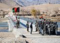
Afghan National Security Forces (ANSF) stand by near the Chutu Bridge during a grand opening ceremony for the bridge in December 2008.
-
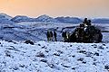
Soldiers from Australia's Special Operations Task Group (SOTG) in December 2009.
-
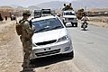
U.S. Army soldier watching Afghans pass during a logistics inspection in Tarinkot.
-
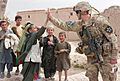
A U.S. soldier socializing with local children in the Darafshan Valley in 2012.


_with_the_56th_Infantry_Brigade_Combat_Team,_Texas_Army_National_Guard,_watches_Afghans_pass_during_a_logistics_130604-A-FS372-018.jpg)

See also
 In Spanish: Provincia de Uruzgán para niños
