Orani facts for kids
Quick facts for kids
Orani
|
|||
|---|---|---|---|
| Municipality of Orani | |||
 |
|||
|
|||

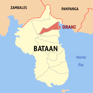
Map of Bataan with Orani highlighted
|
|||
|
OpenStreetMap
|
|||
| Country | Philippines | ||
| Region | Central Luzon | ||
| Province | Bataan | ||
| District | [[{{#property:P7938}} | — Lua error in Module:Wd at line 1804: attempt to index field 'wikibase' (a nil value).]] | ||
| Founded | 1891 | ||
| Barangays | 29 (see Barangays) | ||
| Government
|
|||
| • Type | Sangguniang Bayan | ||
| Area | |||
| • Total | 64.90 km2 (25.06 sq mi) | ||
| Elevation | 14 m (46 ft) | ||
| Highest elevation | 117 m (384 ft) | ||
| Lowest elevation | -4 m (−13.1 ft) | ||
| Population
(2020 census)
|
|||
| • Total | 70,342 | ||
| • Density | 1,083.85/km2 (2,807.16/sq mi) | ||
| • Households | 17,524 | ||
| Economy | |||
| • Income class | 1st municipal income class | ||
| • Poverty incidence |
|
||
| • Revenue | ₱ 349.8 million (2022) | ||
| • Assets | ₱ 500.3 million (2022) | ||
| • Expenditure | ₱ 334.3 million (2022) | ||
| • Liabilities | ₱ 257.1 million (2022) | ||
| Service provider | |||
| • Electricity | Peninsula Electric Cooperative (PENELCO) | ||
| Time zone | UTC+8 (PST) | ||
| ZIP code |
2108
|
||
| PSGC |
[https://psa.gov.ph/classification/psgc/?q=psgc/barangays/{{#pro000®code={{&provcode=
|
||
| IDD : area code | +63 (0)47 | ||
| Native languages | Mariveleño Kapampangan Tagalog |
||
Orani is a town in the Bataan province of the Philippines. It's officially called the Municipality of Orani. In 2020, about 70,342 people lived there.
Contents
- What's in a Name? The Story of Orani
- A Look Back: Orani's History
- Exploring Orani: Geography and Climate
- Who Lives in Orani? Population Details
- Orani's Economy: How People Make a Living
- Running the Town: Orani's Government
- Must-See Spots: Tourism in Orani
- Learning in Orani: Education
- Images for kids
- See also
What's in a Name? The Story of Orani
Legend says that the name "Orani" came from a misunderstanding. A Spanish explorer was in a thick forest in what is now Orani. He saw a local person cutting down a large tree. The Spaniard asked the tree's name. The native replied "narra." The Spaniard thought the native said "no ira," which means "unselfish" in Spanish. He then mixed up the letters from these words to create "Orani." This name eventually became the town's official name.
A Look Back: Orani's History
The town and church of Orani were officially started in 1714. They became an independent missionary center. Dominican friars built the church and used it as their home base in Bataan. Orani grew into a busy town.
However, it faced many challenges. A big earthquake on September 16, 1852, badly damaged the church and the town's government building. Reconstruction began in 1891. But a huge fire on March 16, 1938, burned down most of the town. This included schools, the church, and the town hall. World War II then stopped all rebuilding efforts. After the war, the people of Orani worked hard to rebuild their town once more.
Exploring Orani: Geography and Climate
Orani is about 14 kilometers (9 miles) from Balanga. It is also about 110 kilometers (68 miles) northwest of Manila. You can reach it easily using the Bataan Provincial Expressway.
The town is surrounded by other areas. Hermosa is to the north, and Samal is to the south. To the west is Dinalupihan, and to the east is Manila Bay. Orani covers a total land area of 64.90 square kilometers (25.06 sq mi). This area includes 29 different neighborhoods called barangays. A large part of the land is used for farming or is covered by forests.
Orani's Weather
Orani has a tropical climate. This means it's generally warm all year round. There are two main seasons: a dry season and a wet (rainy) season. The driest months are usually from December to April. The rainy season typically runs from May to November.
Neighborhoods: Barangays of Orani
Orani is divided into 29 smaller areas called barangays. Each barangay has its own smaller sections called puroks and sometimes sitios. These barangays help organize the town's communities.
Who Lives in Orani? Population Details
In 2020, Orani had a population of 70,342 people. This means that for every square kilometer of land, there were about 1,084 people living there. The town's population has grown steadily over the years.
Orani's Economy: How People Make a Living
Orani's economy relies on farming and fishing. Farmers grow crops like rice (palay), coffee, and various vegetables. They also grow peanuts, citrus fruits, and other fruit trees. Some people cultivate cut flowers such as aster, chrysanthemum, and gerbera.
From the forestlands, bamboo and jungle vines can be found. The waters around Orani are rich in seafood. Fishermen catch milkfish, tilapia, prawns, crabs, mussels, and oysters. These resources are important for the town's economy.
Running the Town: Orani's Government
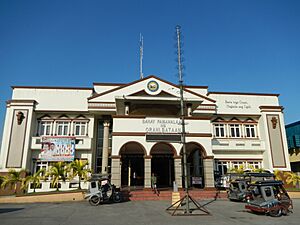
The local government of Orani is based at the Municipal Hall. This building is where the town's leaders work. In the past, during Spanish rule, the main leader was called the Gobernadorcillo. They worked in a building called the Presidencia.
Today, elected officials like the Mayor and Vice Mayor lead the town. They work with the Municipal Council, also known as the Sangguniang Bayan. This council helps make decisions and laws for Orani. The town also has a local court that handles legal matters.
In January 2019, Orani made history. It became the first local government in Bataan to pass a law protecting its people from discrimination. This law ensures fairness for everyone, no matter their age, health, background, or other personal traits.
Must-See Spots: Tourism in Orani
Orani has several interesting places to visit and events to experience:
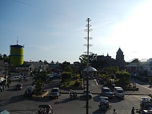
- Orani People's Park: This is a central park in the town's main area, a great place for relaxation.
- Orani Church: Also known as the "Our Lady of the Most Holy Rosary Parish Church of Orani." This beautiful church was built in 1714. It is a historic site and a place of pilgrimage.
- Death March Marker (Silahis): This marker remembers a sad event from World War II, the Bataan Death March. Kaparangan was a temporary camp for prisoners in 1942. A bronze memorial was built here in 1987 to honor those who suffered.
- Pawikan Festival: This festival celebrates the sea turtles (pawikan) that visit the area. It helps raise awareness about protecting these amazing creatures.
Learning in Orani: Education
The Orani Schools District Office manages all schools in the town. This includes both private and public schools, from elementary to high school.
Elementary Schools
- Kaparangan Elementary School
- Orani United Methodist Ecumenical School
- Orani North Elementary School
- Orani South Elementary School
- Pagasa Elementary School
- Pantalan Bago Elementary School
- Pantalan Luma Elementary School
- Pulo Elementary School
- Tala Elementary School
- Talimundoc Elementary School
- Talimundoc Adventist Elementary School
- Tapulao Elementary School
- Paraiso Elementary School
Primary Schools (Kindergarten)
- Little Flower Kindergarten School
- Orani Day Care Center
- Orani North Kiddie School
- Santo Rosario Kindergarten School
- Sola Fide Montessori
Secondary Schools (High Schools)
- Academy of East Asia for Business and Technology (formerly Academy of Queen Mary)
- BLC International School (formerly Bataan Learning Center)
- Diocesan School of Bataan - Holy Rosary Parochial Institute
- Orani United Methodist Ecumenical School
- Jose Rizal Institute - Orani
- Orani National High School
- Orani National High School - Annex 1
- Orani National High School - Pag-Asa Annex
Higher Education
- Bataan Peninsula State University - Orani Campus
Images for kids
See also
 In Spanish: Orani para niños
 | Emma Amos |
 | Edward Mitchell Bannister |
 | Larry D. Alexander |
 | Ernie Barnes |


