
Orca Inlet facts for kids

Orca Inlet is a part of Prince William Sound in southern Alaska. It's like a long, narrow arm of the ocean. The town of Cordova was started on its shore in 1906. All boats and ships traveling to Cordova use Orca Inlet to reach the town.
Geography of Orca Inlet


Orca Inlet is located south and east of Hawkins Island. You can find it at 60°31′25″N 145°52′46″W / 60.52361°N 145.87944°W. The inlet is about 16 miles (26 km) long. It runs towards the southwest. At its widest point, it is about 3 miles (4.8 km) across.
The southern end of Orca Inlet opens into the Gulf of Alaska. Its northern end connects with Orca Bay. The city of Cordova, Alaska is built on the southeast side of Orca Inlet.
History of Orca Inlet
Orca Inlet was first mentioned in a geography book about Alaska in 1906. This information came from a report written in 1897. An important fish processing factory, called the Orca Cannery, used to operate on the south shore of the inlet. There was even a post office there starting in 1894. Another cannery, the Odiak Cannery, was located about 3 miles (4.8 km) southwest of Orca. This is where the city of Cordova is today.
Orca Inlet once had many large beds of Pacific razor clams. People would collect these clams from the shallow areas. They would then ship them out from Cordova. At its best, the clam harvest reached 3.5 million pounds (1.6 million kilograms). However, the number of clams started to drop in the late 1950s.
A huge event changed everything for the clams. In 1964, the Good Friday earthquake hit Alaska. This earthquake lifted the land around the clam beds by about 6 feet (1.8 meters). This sudden uplift exposed the clams to the air, killing many of them. Because of this, the clam industry in the area completely stopped.
Geology and Water Currents
Orca Inlet is a type of valley called a fjord. Fjords are long, narrow, deep inlets of the sea, usually with steep sides. They are formed by glaciers. Along the coast of Orca Inlet, you can see many large, rounded rocks. There are also many bowl-shaped valleys called cirques and hanging valleys. These features show how glaciers carved out the land.
The sides of the fjord are very steep due to glacial erosion. In one spot, the land rises 1,600 feet (490 meters) within just half a mile (0.8 km) of the coast. The southern and central parts of the inlet are quite shallow. This is because they are filled with sand and mud. These deposits came from the glacier that once filled the fjord. They also come from the Copper River and other smaller rivers that flow into the inlet.
These deposits move westward along the coast. They then enter Orca Inlet. Orca Inlet can be a way for boats to enter Prince William Sound from the Gulf of Alaska. However, the shallow water means that only smaller boats can use this route. In 1914, most of the southern part of the inlet was only about 12 feet (3.7 meters) deep or less. The northern part was much deeper, ranging from 90 to 228 feet (27 to 70 meters) deep.
There is Copper ore in the area around Orca Inlet. However, not much mining has happened there.
The water in Orca Inlet moves with the tides. When the tide comes in (flood tide), the current flows southward. When the tide goes out (ebb tide), the current flows northward. At its fastest, the incoming current moves about 1.5 knots (2.8 km/h). The outgoing current moves about 0.8 knots (1.5 km/h) at its peak.
Gallery
-

Seen from Cordova, the sun sets over Orca Inlet
-
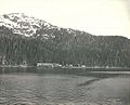
Cannery and village of Orca, about 3 miles (4.8 km) northeast of present-day Cordova, E.S. Curtis, June 1899
-
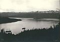
Orca Harbor (the east end of Orca Inlet) from the mountain above the village of Orca, about 3 miles (4.8 km) northeast of present-day Cordova, E.S. Curtis, June 1899


See also
 In Spanish: Orca Inlet para niños
