
Orford Ness facts for kids
Quick facts for kids Orford Ness |
|
|---|---|
| Near Orford, Suffolk | |

Looking towards Orford Ness from Orford castle
|
|

Orford Ness
|
|
| Coordinates | 52°04′53″N 01°33′31″E / 52.08139°N 1.55861°E |
| Type | National Nature Reserve, Site of Special Scientific Interest, internationally important site for nature conservation, former military test site |
| Site information | |
| Operator | Ministry of Defence, Atomic Weapons Research Establishment, National Trust for Places of Historic Interest or Natural Beauty |
| Status | Inactive |
| Site history | |
| In use | 1913 – early 1983 |
Orford Ness is a long, narrow strip of land made of shingle (small, rounded stones) on the Suffolk coast in Great Britain. It's connected to the mainland near Aldeburgh and stretches down to Orford. This unique piece of land is separated from the mainland by the River Alde. It was formed over many years by waves and currents moving stones along the coast.
Near the middle of Orford Ness, there used to be a lighthouse called Orfordness Lighthouse. It was taken down in 2020 because the sea was getting too close. When you see "Orfordness" written as one word, it usually refers to the lighthouse or the old radio station.
Contents
Discovering Orford Ness
Orford Ness is a very important place for nature. It has a huge area of "vegetated shingle," which means shingle covered in plants. This type of habitat is rare around the world and is very delicate.
A Special Place for Nature
Along with Havergate Island, Orford Ness is a special National Nature Reserve. It's also part of many other protected areas. These include the Alde-Ore Estuary Site of Special Scientific Interest (SSSI). It's also recognized internationally for its wildlife. This shows how important it is to protect the plants and animals that live here.
Orford Ness's Secret Past

For many years, the Ministry of Defence owned Orford Ness. They used it for secret military tests during both World Wars and the Cold War.
Early Radio Experiments
In 1929, an important experiment called the Orfordness Beacon was set up here. It was one of the first attempts at long-range radio navigation. This helped ships and planes find their way using radio signals.
The Birth of Radar
In the 1930s, Orford Ness became the testing ground for a new defense system. This system would later be known as radar. Scientists like Robert Watson-Watt proved that radar technology worked here. After their success, they moved to Bawdsey Manor nearby. There, they developed the Chain Home radar system. This system played a crucial role in the Battle of Britain during World War II.
Atomic Research and the 'Pagodas'
The Atomic Weapons Research Establishment also had a base on Orford Ness. They used it to test how equipment would perform in different environments. This helped them make sure their devices worked correctly in real-world conditions. Many of the buildings from this time are still visible from Orford, including the unique 'pagodas'.
Cobra Mist and Radio Broadcasting
In the late 1960s, a large experimental radar system called Cobra Mist was built on the peninsula. It was a joint project between Britain and America. Cobra Mist closed in 1973.
Later, in the late 1970s and early 1980s, the site became the Orfordness transmitting station. This powerful radio station broadcast the BBC World Service to Europe. It operated until 2011. In 2017, Radio Caroline began broadcasting from the site.
Orford Ness Today
Today, the National Trust owns Orford Ness. It's open to the public as the Orford Ness National Nature Reserve. However, visitors must follow strict rules. This is to protect the fragile natural habitats. It also keeps people safe from any remaining dangers from its military past. You can only visit by taking a special ferry from Orford Quay on certain days.
The site has a unique feel. It combines wild nature with old military buildings. These include the Bomb Ballistics Building and the 'pagodas'. It's a place that makes you think about its past and its importance for nature.
Mysterious Stories
Because of its secret military history, many strange stories have been told about Orford Ness. One popular story claimed that Nazi troops tried to invade England here during World War II. They supposedly landed near Shingle Street and were stopped by a wall of fire. Official records released in 1993 showed this story was not true.
Another story links the flashes from the old lighthouse to the Rendlesham Forest incident. This was a famous UFO sighting that happened nearby in 1980. The lighthouse was eventually taken down in 2020.
The Geography of Orford Ness
.svg)
Orford Ness is the largest vegetated shingle spit in Europe. A "ness" means a point of land sticking out into the sea. It is about 10 kilometres (6.2 miles) long. The whole area covers about 2,230 acres (900 hectares).
How the Spit Was Formed
The spit is mostly made of flint stones. These stones were carried and deposited by waves over time. This process is called long-shore drift. Storm waves play a big part in its formation. They throw shingle over the top of the beach, creating stable ridges.
The size and shape of Orford Ness are always changing. It can grow or shrink depending on the sea. For example, it grew by 64 metres (210 feet) per year between 1962 and 1967. Its exact age is unknown, but before the year 1200, Orford was likely a port directly on the open sea.
Images for kids
-
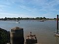
View from the Orford Ness dock towards Orford Quay.
-
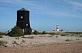
The 'Black Beacon' radio navigation tower and the lighthouse.
-
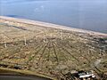
Aerial view of the Orfordness [sic] transmitting station.
-
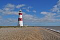
The lighthouse
-
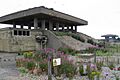
Exterior of two 'pagodas'.
-
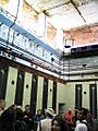
Interior of a 'pagoda'.


