Osenovlag Island facts for kids

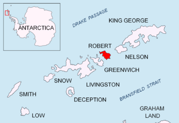
Location of Robert Island in the South Shetland Islands
|
|
|
Location of Osenovlag Island
|
|
| Geography | |
|---|---|
| Location | Antarctica |
| Coordinates | 62°20′54.6″S 59°40′25″W / 62.348500°S 59.67361°W |
| Archipelago | South Shetland Islands |
| Administration | |
| Administered under the Antarctic Treaty System | |
| Demographics | |
| Population | Uninhabited |
Osenovlag Island (which means ostrov Osenovlag in Bulgarian) is a small island located near Antarctica. It's the island furthest to the east in a group called the Onogur Islands. These islands are found off the northwest coast of Robert Island in the South Shetland Islands.
The island is named after a place called Osenovlag in Western Bulgaria.
About Osenovlag Island
Osenovlag Island is a rocky piece of land. It stretches about 510 meters (1,673 feet) from its southeast to its northwest end and is about 130 meters (426 feet) wide.
Long ago, in the early 1800s, people who hunted seals often visited this area.
Maps of the island were first made by British explorers in 1968. Later, Bulgarian explorers created their own maps in 2009.
Where is Osenovlag Island?
Osenovlag Island is located at specific coordinates: 62°20′54.6″S, 59°40′25″W.
It is about 3.55 kilometers (2.2 miles) northeast of a spot called Fort William Point. It's also about 1.24 kilometers (0.77 miles) southwest of Hammer Point.
A narrow passage, about 90 meters (295 feet) wide, separates Osenovlag Island from Shipot Point.
Maps of the Area
You can find Osenovlag Island on detailed maps of the Antarctic region. For example, there's a topographic map from 2009 (with a second edition in 2010) that shows Livingston Island, Greenwich Island, Robert Island, Snow Island, and Smith Island.
- L.L. Ivanov. Antarctica: Livingston Island and Greenwich, Robert, Snow and Smith Islands. Scale 1:120000 topographic map. Troyan: Manfred Wörner Foundation, 2009. ISBN: 978-954-92032-6-4
 | John T. Biggers |
 | Thomas Blackshear |
 | Mark Bradford |
 | Beverly Buchanan |


