Otranto, Iowa facts for kids
Quick facts for kids
Otranto, Iowa
|
|
|---|---|

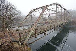
The former Otranto Bridge over the Cedar River
|
|
| Country | United States |
| State | Iowa |
| County | Mitchell |
| Township | Otranto |
| Area | |
| • Total | 0.41 sq mi (1.06 km2) |
| • Land | 0.41 sq mi (1.06 km2) |
| • Water | 0.00 sq mi (0.00 km2) |
| Elevation | 1,171 ft (357 m) |
| Population
(2020)
|
|
| • Total | 27 |
| • Density | 65.85/sq mi (25.42/km2) |
| Time zone | Central (CST) |
| ZIP code |
50472 (St. Ansgar)
|
| FIPS code | 19-60285 |
Otranto is a small community in Mitchell County, Iowa, located in the U.S. state of Iowa. It's known as an "unincorporated community," which means it doesn't have its own local government like a city or town. It's also a "census-designated place," meaning the U.S. government counts its population for official records. In 2020, only 27 people lived in Otranto, which was the same number as in 2010.
Location and Landscape
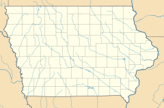
Otranto is found in the northwestern part of Mitchell County, Iowa. It is about 7 miles (11 km) northwest of St. Ansgar, Iowa, which is where Otranto gets its mail. The community is also about 18 miles (29 km) northwest of Osage, Iowa, which is the main town for the county.
The border with the state of Minnesota is only about 3 miles (5 km) north of Otranto. The community is located right along the Cedar River. This river flows about 4 miles (6 km) southwest of another small place called Mona, Iowa.
Population Facts
The number of people living in Otranto has stayed the same for a while.
- In 2010, the population was 27 people.
- In 2020, the population was still 27 people.
This information comes from the official U.S. Decennial Census, which counts everyone in the country every ten years.
See also
 In Spanish: Otranto (Iowa) para niños
 | Mary Eliza Mahoney |
 | Susie King Taylor |
 | Ida Gray |
 | Eliza Ann Grier |


