Ottoway, South Australia facts for kids
Quick facts for kids OttowayAdelaide, South Australia |
|||||||||||||||
|---|---|---|---|---|---|---|---|---|---|---|---|---|---|---|---|
| Postcode(s) | 5013 | ||||||||||||||
| Location |
|
||||||||||||||
| LGA(s) | City of Port Adelaide Enfield | ||||||||||||||
| State electorate(s) | Port Adelaide | ||||||||||||||
| Federal Division(s) | Hindmarsh | ||||||||||||||
|
|||||||||||||||
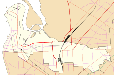
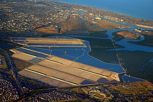
Ottoway is a suburb in Adelaide, South Australia. It is mostly an industrial area. This means it has many factories and businesses. Ottoway is located about 12 kilometers (7.5 miles) northwest of the main city center of Adelaide. It is part of the City of Port Adelaide Enfield local government area.
The Story of Ottoway
Ottoway has an interesting history. The land where Ottoway now stands was first granted in 1851. A person named George Dale received this land.
How Ottoway Got Its Name
In 1883, the land was divided into smaller pieces. This process is called subdivision. Surveyors and sellers named Ferry, Moore & Wallmann decided to call the new suburb "Ottoway."
However, there is another idea about the name. A historian named Geoff Manning wrote a book about place names in South Australia. He suggested the suburb might have been named after Thomas Finch Ottaway. Thomas Ottaway was a publican, which means he owned a pub. He bought the land from George Dale in 1853.
Where is Ottoway Located?
Ottoway is easy to find on a map. Its northern and western edges are mostly next to the Dry Creek-Port Adelaide railway line. This is a train track that runs through the area.
The southern border of Ottoway is along a major road called Grand Junction Road. Another important road, the Port River Expressway, also passes through this suburb. These roads help people and goods travel in and out of Ottoway.
 | Sharif Bey |
 | Hale Woodruff |
 | Richmond Barthé |
 | Purvis Young |


