
Ouseburn Valley facts for kids
Quick facts for kids Ouseburn Valley |
|
|---|---|

Location in Tyne and Wear
|
|
| Location | Tyne and Wear, England, UK |
| OS grid | NZ263644 |
| Coordinates | 54°58′26″N 1°35′24″W / 54.974°N 1.590°W |
The Ouseburn Valley is a special place in Newcastle upon Tyne, England. It's the valley of the Ouseburn, a small river that flows into the bigger River Tyne. This area is known for its interesting history and vibrant modern life. It's like a hidden gem close to Newcastle's city centre, full of art, food, and community spirit.
A Look Back: Industrial History
Long ago, the Ouseburn Valley was a very important place for the start of the Industrial Revolution in Newcastle. Many factories and workshops were built here. Coal was a huge part of this. It was brought from the Town Moor through a special underground passage called the Victoria Tunnel.
The Ouseburn river was affected by the tides. This meant that at low tide, local boats called wherries could be loaded with coal. These wherries would then be pulled out to bigger ships, like collier brigs and snows, waiting in the River Tyne. These ships would carry the coal to other places.
The Modern Ouseburn Valley
Today, the Ouseburn Valley is a lively and creative area. It's a great spot to find unique places to eat and enjoy music. You can find delicious food, from fresh bread and pastries to modern meals. Many people visit to try new cafes and restaurants. It's a place where artists and musicians gather, making it a hub for culture and fun.
Amazing Bridges
Three impressive bridges stretch high above the Ouseburn Valley. They are very close to each other. One is the Ouseburn Viaduct, which carries a railway. Another is the Byker Viaduct, used by the Tyne and Wear Metro trains. The third is the Byker Bridge, which is a road bridge for cars and people.
Did you know that Hadrian's Wall once crossed the Ouseburn river near where the Byker road bridge is now? It's thought to have run through the area where the City Farm is today. You can't see the wall itself above ground anymore. However, there is an information board on the east side of the river. It tells you more about where the wall used to be.
Images for kids
-
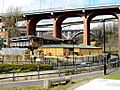
The Byker Bridge, seen from the valley floor. The Byker Viaduct and the Ouseburn Viaduct are behind it. The Ouseburn city farm in front is on the line of Hadrian's Wall.

