Owl's Head (Franconia, New Hampshire) facts for kids
Quick facts for kids Owl's Head |
|
|---|---|

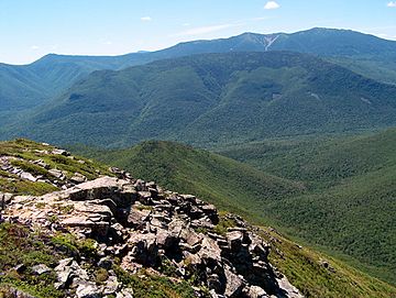
Owl's Head from Bondcliff, with Franconia Ridge behind
|
|
| Highest point | |
| Elevation | 4,025 ft (1,227 m) |
| Prominence | 825 ft (251 m) |
| Listing | White Mountain 4000-Footers |
| Geography | |
| Location | Franconia, New Hampshire, U.S. |
| Parent range | White Mountains |
| Climbing | |
| Easiest route | Hike |
Owl's Head is a mountain in Franconia, New Hampshire. It stands 4,025 feet (1,227 meters) tall. This mountain is found in the Pemigewasset Wilderness. This is a wild area within the White Mountain National Forest. Owl's Head is located between two waterways: the Franconia Branch of the Pemigewasset River to its east and Lincoln Brook to its west and south.
Contents
What Makes Owl's Head Special?
Owl's Head is one of the 48 mountains in the White Mountains that are over 4,000 feet tall. These are often called "four-thousand footers." Even though it's tall, Owl's Head is known for some things it doesn't have.
Not the Tallest
Out of the 48 tallest mountains, Owl's Head is number 43 in height. This means it's one of the shorter ones on the list.
No Official Trails
Most mountains have official trails that hikers can follow. Owl's Head is different. It is the only one of the 48 "four-thousand footers" without an official path to its top. There is an unofficial path, sometimes called a "herd path." This path is not maintained, but it gets very close to the summit. A herd path is a trail made by animals or people walking the same way many times.
No Views from the Top
When you reach the very top of Owl's Head, you won't see much. The trees are so tall and thick that they block any views. However, there are some nice views from a spot called the Owl's Head Slide. This is a rocky area you pass while climbing the unofficial path.
Hard to Reach
Owl's Head is quite far from any roads. This makes it a bit tricky to get to.
- To the south, the East Branch of the Pemigewasset River separates it from the Kancamagus Highway.
- To the west, the steep Franconia Ridge stands between it and Interstate 93.
- To the north, Garfield Ridge is between it and U.S. Route 3.
- To the east, the Twin Range and Willey Range separate it from U.S. Route 302.
Because it's so remote and doesn't have official trails, many hikers save Owl's Head for last. It's often the final mountain they climb to complete their list of all 48 "four-thousand footers."
The True Summit Discovery
In 2005, something interesting was discovered about Owl's Head. Hikers had always gone to a certain spot they thought was the summit. But it turned out that this spot was actually a bit lower than the real top. The true summit is about 0.2 miles (320 meters) north along the mountain's ridge. For now, the committee that tracks the "4,000-footer" climbs still accepts climbs to the traditional, slightly lower peak.
 | John T. Biggers |
 | Thomas Blackshear |
 | Mark Bradford |
 | Beverly Buchanan |

