
Mount Bond facts for kids
Quick facts for kids Mount Bond |
|
|---|---|

Mount Bond from the Bondcliff ridge
|
|
| Highest point | |
| Elevation | 4,698 ft (1,432 m) |
| Prominence | 298 ft (91 m) |
| Listing | White Mountain 4000-Footers |
| Geography | |
| Location | Lincoln, New Hampshire, U.S. |
| Parent range | Twin Range |
| Topo map | USGS South Twin Mountain |
| West Bond | |
|---|---|
 |
|
| Highest point | |
| Elevation | 4520+ ft (1378+ m) |
| Prominence | 200 ft (61 m) |
| Listing | White Mountain 4000-Footers |
| Geography | |
| Location | New Hampshire, U.S. |
| Bondcliff | |
|---|---|

Bondcliff at sunset
|
|
| Highest point | |
| Elevation | 4,265 ft (1,300 m) |
| Prominence | 205 ft (62 m) |
| Listing | White Mountain 4000-Footers |
| Geography | |
| Location | New Hampshire, U.S. |
Mount Bond is a tall mountain found in New Hampshire, United States. It is part of the Twin Range within the larger White Mountains. The mountain was named after Professor George Phillips Bond, who was a famous astronomer from Harvard University.
Mount Bond is a popular spot for hikers. It is known for its beautiful views and challenging trails.
What is Mount Bond?
Mount Bond stands at 4,698 feet (1,432 meters) high. It is located in Grafton County. To its north, you can find Mount Guyot.
The Bond Peaks
Mount Bond has two smaller peaks that are part of its group:
- West Bond: This peak is 4,520 feet (1,378 meters) tall.
- Bondcliff (also called "The Cliffs"): This peak is 4,265 feet (1,300 meters) tall.
All three of these peaks—Mount Bond, West Bond, and Bondcliff—are on a special list. This list, made by the Appalachian Mountain Club, includes all the mountains in the White Mountains that are over 4,000 feet (1,219 meters) high. These are often called "Four-thousand footers".
Where is Mount Bond Located?
Mount Bond is located inside the Pemigewasset Wilderness Area. This is a protected natural space where the land is kept wild.
Water from Mount Bond flows in different directions. To the east and west, the water goes into the North Fork and Franconia Branch of the East Branch of the Pemigewasset River. From there, the water eventually reaches the Merrimack River and then flows into the Gulf of Maine in Massachusetts.
Images for kids
-
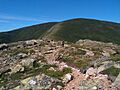
Mount Bond from the Bondcliff ridge
-
-
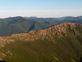
Bondcliff at sunset
