Oxbow, Maine facts for kids
Quick facts for kids
Oxbow North, Maine
|
|
|---|---|
|
Township
|
|
| Nickname(s):
Oxbow
|
|

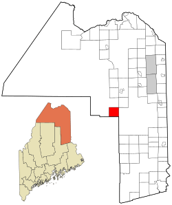
Location of Oxbow, Maine
|
|
| Country | United States |
| State | Maine |
| County | Aroostook |
| Area | |
| • Total | 38.3 sq mi (99.1 km2) |
| • Land | 37.8 sq mi (97.9 km2) |
| • Water | 0.5 sq mi (1.2 km2) |
| Elevation | 679 ft (207 m) |
| Population
(2010)
|
|
| • Total | 66 |
| • Density | 1.7/sq mi (0.67/km2) |
| Time zone | UTC-5 (Eastern (EST)) |
| • Summer (DST) | UTC-4 (EDT) |
| ZIP code |
04764
|
| Area code(s) | 207 |
| FIPS code | 23-56205 |
| GNIS feature ID | 0582657 |
Oxbow, officially called Oxbow North and Township 9 Range 6, is a small, quiet area in Aroostook County, Maine, United States. It's known as an "unincorporated township." This means it doesn't have its own local government like a city or town. Instead, it's managed by the state of Maine as part of its "Unorganized Territory." In 2010, about 66 people lived there. By 2016, the number was estimated to be around 50.
Contents
A Brief History of Oxbow
Oxbow was first settled in 1842 by two brothers, Elias and Samuel Hayden. They came from another part of Maine called Somerset County. More people soon moved to Oxbow to start farms and build mills, which are places that process materials like wood.
Becoming and Un-Becoming a Plantation
Because more people were moving in, the residents decided to officially organize as Oxbow Plantation in 1870. A "plantation" is a type of small town government in Maine.
In 1994, there was a vote to "deorganize" Oxbow, meaning to stop being a plantation and let the state manage it. This vote failed. However, in November 2015, Oxbow residents voted again, this time unanimously, to deorganize. The main reason for this decision was to lower their property taxes.
The Deorganization Process
In March 2016, a group of lawmakers from the Maine Legislature agreed to let Oxbow deorganize. Later that year, in November 2016, the town residents voted again, with 37 people in favor and only 2 against, to continue with the process. Oxbow officially stopped being a plantation and became an unincorporated territory on July 1, 2017.
Geography of Oxbow
Oxbow is located in a beautiful part of Maine. According to the United States Census Bureau, the total area of the township is about 99.1 square kilometers (which is about 38.3 square miles).
Land and Water Areas
Most of Oxbow is land, covering about 97.9 square kilometers (37.8 square miles). The rest, about 1.2 square kilometers (0.5 square miles), is water. This means that about 1.22% of Oxbow's total area is covered by water.
Population and People
| Historical population | |||
|---|---|---|---|
| Census | Pop. | %± | |
| 1870 | 100 | — | |
| 1880 | 127 | 27.0% | |
| 1890 | 94 | −26.0% | |
| 1900 | 153 | 62.8% | |
| 1910 | 181 | 18.3% | |
| 1920 | 198 | 9.4% | |
| 1930 | 176 | −11.1% | |
| 1940 | 178 | 1.1% | |
| 1950 | 189 | 6.2% | |
| 1960 | 137 | −27.5% | |
| 1970 | 92 | −32.8% | |
| 1980 | 84 | −8.7% | |
| 1990 | 69 | −17.9% | |
| 2000 | 56 | −18.8% | |
| 2010 | 66 | 17.9% | |
| 2016 (est.) | 50 | −24.2% | |
| U.S. Decennial Census | |||
The population of Oxbow has changed over the years. A census is an official count of the population. In the year 2000, there were 56 people living in Oxbow. These people lived in 29 different homes, and 20 of those homes were families.
Population Changes Over Time
The population density, which tells us how many people live in a certain area, was about 0.67 people per square kilometer in 2010. Over the years, the population has gone up and down. For example, in 1870, there were 100 people, and it reached a high of 198 people in 1920. By 2010, the population was 66, and it was estimated to be around 50 in 2016.
Age Groups in Oxbow
In 2000, the population was spread out across different age groups. About 8.9% of the people were under 18 years old. About 5.4% were between 18 and 24. The largest groups were those aged 45 to 64 (35.7%) and those aged 65 or older (32.1%). The median age, which is the middle age of the population, was 52 years old.
See also
 In Spanish: Oxbow (Maine) para niños
 | Mary Eliza Mahoney |
 | Susie King Taylor |
 | Ida Gray |
 | Eliza Ann Grier |

