Oxford Circle, Philadelphia facts for kids
Quick facts for kids
Oxford Circle
|
|
|---|---|

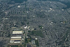
Aerial view of Oxford Circle
|
|
| Country | |
| State | Pennsylvania |
| County | Philadelphia County |
| City | Philadelphia |
| Area code(s) | 215, 267, and 445 |
Oxford Circle is a lively neighborhood in the lower Northeast part of Philadelphia, Pennsylvania. It gets its name from a busy traffic circle where Roosevelt Boulevard and Oxford Avenue meet. This area is known for its many brick and stone row houses. While it has a famous traffic circle, Oxford Circle doesn't have super strict borders.
Sometimes, people use "Oxford Circle" to talk about the nearby Summerdale neighborhood. Summerdale is mostly west of Roosevelt Boulevard. However, it's generally seen as a different area from the Oxford Circle described here.
Contents
Exploring Oxford Circle's Location
Oxford Circle has some natural and man-made borders. To the southeast, you'll find Roosevelt Boulevard. Oxford Avenue is to the west. Devereaux Avenue marks the northeast, and Cheltenham Avenue is to the south.
The area's shape is partly based on three creeks. These creeks were here long before the neighborhood was built. Most of Oxford Circle sits between these waterways. To the northwest was the Wissinoming Creek. It flowed from above Castor Avenue towards Mayfair. To the east is the Pennypack Creek. To the southeast, you'll find the Tacony Creek. This creek is called "Tookany" north of the city. It flows into Frankford Creek. Even in 1928, a smaller branch of the Tacony Creek flowed through the area. It connected to the main Tacony Creek, which empties into the Delaware River. This is near where the Betsy Ross Bridge is today.
A Look Back at Oxford Circle's Past
Oxford Circle was once part of Oxford Township. It was one of Philadelphia's early suburbs. The land, with its creeks like Tacony and Wissinoming, was mostly used for farming. This changed just before World War II. Developers bought the land to build homes.
Most of the brick and stone row houses you see today were built by the Hyman Korman Company. They started building in the early 1940s and continued into the 1950s. In those years, and through the 1960s and 1970s, Oxford Circle was a successful neighborhood. Many middle-class families lived there.
Since the late 1990s, the neighborhood has seen big changes. Today, Oxford Circle is home to a very diverse group of people. You'll find Caucasian, Jewish, Koreans, and Hispanic residents. Many Hispanic residents are from Puerto Rico, the Dominican Republic, and Brazil. There are also West Indians, mostly from Haiti, and African Americans. This mix of cultures makes Oxford Circle a vibrant place.
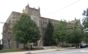
The Laura H. Carnell School is an important landmark here. It was named after a famous educator, Laura H. Carnell. This school was added to the National Register of Historic Places in 1988. This means it's recognized for its historical importance.
Important Places in Oxford Circle
Oxford Circle has many important buildings and parks. Here are some of them:
- Old Trinity Church
- Tarken Playground
- Jardel Playground
- Max Myers Playground
- Northeast High School
- Spruance, Carnell, and Moore Elementary Schools
- Fels Senior High School
- Woodrow Wilson Middle School
- Castor Ave. (a popular shopping area)
- Bushrod Library
- Oxford Circle (the famous traffic circle) 40°01′53″N 75°05′04″W / 40.031482°N 75.08449°W
- Saint Martin of Tours Roman Catholic Church
Local Libraries
The Free Library of Philadelphia helps the community with its Bushrod Branch. You can find this library at 6304 Castor Avenue, near Stirling Street. It's a great place to find books and learn new things.


