
Packsaddle Mountain (Llano County, Texas) facts for kids
Quick facts for kids Packsaddle Mountain |
|
|---|---|

Packsaddle Mountain Cliff Face
|
|
| Highest point | |
| Elevation | 1,628 ft (496 m) |
| Prominence | 548 ft (167 m) |
| Parent peak | Enchanted Rock |
| Geography | |

Packsaddle Mountain
Location in Texas
|
|
| Parent range | Llano Uplift |
| Topo map | USGS Cap Mountain |
Packsaddle Mountain is a special hill in Llano County, Texas, U.S. It's named "Packsaddle" because its two peaks look like a saddle used on a horse or mule. This mountain is important to both history buffs and scientists who study rocks.
In 1873, it was the place of the Packsaddle Mountain Fight, which was the last big battle with Native Americans in that area. Today, Packsaddle Mountain is part of a large ranch.
Contents
History of Packsaddle Mountain
Early Mining and Lost Gold
People believe that Spanish explorers mined for gold on Packsaddle Mountain before the Texas Revolution. Some even think it might be the site of Los Almagres, a famous lost mine linked to Jim Bowie. In the 1920s, there was new interest in finding gold here, but no major discoveries were made.
The Packsaddle Mountain Fight
Packsaddle Mountain was the site of an important event called the Packsaddle Mountain Fight. This happened on August 4, 1873, and involved a group of Apache tribesmen. It was the last major battle with Native Americans in this part of Texas.
The fight began when a woman from the Moss Ranch was injured by an arrow. A group of eight ranchers, including W.B. Moss and his two brothers, decided to follow those responsible. They found about 21 Apaches camped on Packsaddle Mountain. During the fight, at least three tribesmen were killed, and three ranchers were hurt.
A historical marker in Texas tells about this event. It says that Captain J. R. Moss, Stephen B. Moss, William B. Moss, Eli Lloyd, Arch Martin, Pink Ayers, E. D. Harrington, and Robert Brown fought a group of Native Americans much larger than their own. This marker marks the last Apache battle in this area.
Geography of Packsaddle Mountain
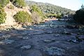
Packsaddle Mountain is 1,628 feet tall. The higher of its two peaks rises 650 feet above Highway 71. The land around the mountain changes from flat to rolling hills, and some parts are very steep.
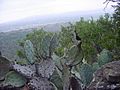
The ground varies from shallow and rocky to deep, fine, sandy soil. The plants growing here are mostly live oak trees and Ashe juniper trees.
Images for kids
-
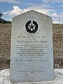
Packsaddle - Mountain Historical Monument
-
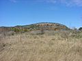
Packsaddle - Mountain View from CR 309
-
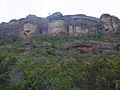
Packsaddle - Close View of Cliff
-
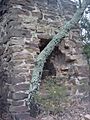
Packsaddle - Old Silver Smelting Furnace
-
Packsaddle - Old Rock Quarry
-
Packsaddle - View towards Llano, TX


