
Palmas, Tocantins facts for kids
Quick facts for kids
Palmas
|
|||
|---|---|---|---|
|
Municipality
|
|||
| Município de Palmas Municipality of Palmas |
|||

From the top; clockwise: Tocantins River Bridge; Araguaia Palace; Tocantins River; Aerial view of Palmas; Súplica dos Pioneiros monument and Coluna Prestes Memorial.
|
|||
|
|||
| Nickname(s):
Capital Ecológica (Ecological Capital)
|
|||
| Motto(s):
Co Yvy Ore Retama (Tupi for 'This Land is Ours'; in Portuguese: Esta Terra é Nossa)
|
|||

Localization of Palmas in Tocantins
|
|||

Palmas
Location in Brazil
|
|||
| Country | |||
| Region | North | ||
| State | |||
| Founded | May 20, 1989 | ||
| Area | |||
| • Total | 2,218.93 km2 (856.73 sq mi) | ||
| Elevation | 230 m (755 ft) | ||
| Population
(2020)
|
|||
| • Total | 306,296 | ||
| • Density | 129,24/km2 (33,470/sq mi) | ||
| Demonym(s) | Palmense | ||
| Time zone | UTC−3 (BRT) | ||
| Postal Code |
From 77000-001 to 77249-999
|
||
| Area code | +55 63 | ||
| HDI (2010) | 0.788 – high | ||


Palmas is the capital and largest city in the state of Tocantins, Brazil. Its name means "Palm trees." In 2020, about 306,296 people lived there. The larger area around Palmas, called the metropolitan area, has about 471,639 people.
Palmas is a special city because it was built from scratch starting in 1990. It was designed to be the capital of the new state of Tocantins, which was created in 1988. The goal was to help develop this part of Brazil and create new jobs. The city has a very organized road system, much like Brasília, Brazil's national capital. There's a big park in the middle and a long main avenue running north to south. Palmas is also home to the Federal University of Tocantins.
In 2002, a large power plant called the Lajeado Hydroelectric Power Plant was finished on the Tocantins River. This created a big lake and new beaches for the city. A huge bridge, the Fernando Henrique Cardoso Bridge, was also built. It is 8 miles (8 km) long and connects Palmas to a major highway and the town of Luzimangues.
The Palmas Airport helps people travel to and from many other Brazilian cities.
Contents
History of Palmas
Palmas became the capital of Tocantins in 1990. Before that, the capital was Miracema do Tocantins. Palmas was chosen as the new capital when the state was created.
Geography and Nature
Tocantins state is located between the Amazon Rainforest and the coastal savanna areas. This means it has a mix of different landscapes. Many rivers flow through the state, including the Tocantins River. Scientists have found over 20 important ancient sites in the state, showing early cultures lived there.
A large part of the Lajeado State Park is located within the Palmas area. About 88% of this 9,931-hectare park is in the municipality.
Palmas Climate
Most of Tocantins, including Palmas, is in a large Brazilian region called the cerrado. The cerrado has a hot, somewhat humid climate. It has clear seasons: a dry winter from May to September and a rainy season from October to April. The yearly rainfall is usually between 800 and 1600 mm. The soil here is often old, deep, and doesn't have many nutrients naturally.
Palmas is one of the hottest capital cities in Brazil. During the dry season (May to September), temperatures can get very high, often above 30°C. It's not as hot during the rainy season because heavy rains and clouds help keep things cooler. Palmas gets a good amount of rain, about 1,300 mm per year. The city is in a valley near the Tocantins River and is surrounded by mountains on three sides. Its low elevation (195 meters above sea level) makes hot days feel even more humid and uncomfortable.
| Climate data for Palmas (1991–2020) | |||||||||||||
|---|---|---|---|---|---|---|---|---|---|---|---|---|---|
| Month | Jan | Feb | Mar | Apr | May | Jun | Jul | Aug | Sep | Oct | Nov | Dec | Year |
| Mean daily maximum °C (°F) | 31.8 (89.2) |
31.6 (88.9) |
31.8 (89.2) |
32.8 (91.0) |
33.8 (92.8) |
34.5 (94.1) |
35.2 (95.4) |
36.8 (98.2) |
37.3 (99.1) |
35.1 (95.2) |
33.0 (91.4) |
32.3 (90.1) |
33.8 (92.8) |
| Daily mean °C (°F) | 26.1 (79.0) |
26.1 (79.0) |
26.2 (79.2) |
26.7 (80.1) |
27.0 (80.6) |
26.5 (79.7) |
26.5 (79.7) |
28.2 (82.8) |
29.5 (85.1) |
28.1 (82.6) |
27.0 (80.6) |
26.5 (79.7) |
27.0 (80.6) |
| Mean daily minimum °C (°F) | 22.3 (72.1) |
22.3 (72.1) |
22.5 (72.5) |
22.7 (72.9) |
22.1 (71.8) |
20.3 (68.5) |
19.6 (67.3) |
20.9 (69.6) |
23.4 (74.1) |
23.1 (73.6) |
22.7 (72.9) |
22.6 (72.7) |
22.0 (71.6) |
| Average precipitation mm (inches) | 298.6 (11.76) |
260.0 (10.24) |
264.0 (10.39) |
179.8 (7.08) |
60.5 (2.38) |
6.3 (0.25) |
0.9 (0.04) |
1.3 (0.05) |
46.2 (1.82) |
143.9 (5.67) |
223.6 (8.80) |
264.5 (10.41) |
1,749.6 (68.88) |
| Average precipitation days (≥ 1 mm) | 13 | 13 | 11 | 7 | 2 | 0 | 0 | 0 | 2 | 8 | 12 | 13 | 81 |
| Average relative humidity (%) | 80.9 | 80.8 | 82.0 | 78.5 | 70.8 | 59.2 | 50.9 | 43.7 | 47.8 | 65.6 | 75.0 | 78.1 | 67.8 |
| Mean monthly sunshine hours | 152.8 | 136.9 | 148.8 | 181.1 | 239.2 | 273.3 | 297.1 | 292.0 | 237.2 | 194.8 | 164.1 | 159.7 | 2,477 |
| Source: Instituto Nacional de Meteorologia (precipitation days 1961–1990) | |||||||||||||
Palmas Vegetation

Even though Palmas is technically in the Amazon basin, it doesn't have a rainforest. Instead, you'll find short trees and shrubs typical of the cerrado region. When the city was being built, many of the original trees were kept in green areas along the wide streets. This means many street trees in Palmas are older than the city itself, which started in 1990. You'll also see many palm trees planted along the main road, Avenida JK.
Palmas Economy

Palmas was planned to be the main economic and administrative center for Tocantins. The service industry, like shops and businesses, is the biggest part of its economy. Farming is also important, with small farms near the city and larger farms growing soybeans and raising animals in the Buritirana district.
Most businesses in Palmas are formal, meaning they are officially registered. Small businesses make up over 80% of the companies in the city.
Palmas has four industrial areas, located near highways TO-050 and TO-010. These areas help with manufacturing and other industries.
Today, Palmas is a major center for trade and business. Its influence reaches across all of Tocantins and into parts of neighboring states like Pará, Mato Grosso, and Maranhão.
Many national banks have branches in Palmas, including Banco do Brasil, Bradesco, Caixa Econômica Federal, and Itaú Unibanco. There are also many ATMs available.

In 2007, the city's Gross Domestic Product (GDP), which measures the value of all goods and services produced, grew a lot. This was due to investments by the city government. Palmas's GDP grew by 6%, which was much higher than Brazil's overall growth of 3.5% that year. This growth has attracted big investments, like the Capim Dourado Shopping mall and large supermarkets.
City Government

Like all cities in Brazil, Palmas has its own local government. It has an Executive branch led by the Mayor and a Legislative branch, which is the Local Assembly. Since it was founded, Palmas has had five elected Mayors. The current Mayor is Cinthia Ribeiro.
Mayors of Palmas
- Fenelon Barbosa, 1990–1992
- Eduardo Siqueira Campos, 1993-1996
- Odir Rocha, 1997–2000
- Nilmar Ruiz, 2001-2004
- Raul Filho, 2005-2012
- Carlos Amastha, 2013-2018
- Cinthia Ribeiro, 2018-
People and Culture
Sister Cities
Palmas has special connections with other cities around the world:
 Araguaína, Tocantins, Brazil
 Colorado Springs, Colorado, United States
Education in Palmas
Palmas has several important educational institutions:
- Universidade Federal do Tocantins (UFT)
- Centro Universitário Luterano de Palmas (Ceulp-Ulbra)
- Faculdade Católica do Tocantins (Católica do Tocantins)
- Fundação Universidade do Tocantins (Unitins)
- Faculdade Objetivo

_-_UFT.jpg)
Tourism and Fun
Palmas is close to Taquaruçu, a village known for ecotourism in the hills. It has a cooler climate and beautiful natural surroundings. Many tourists from Palmas, other parts of Brazil, and even other countries visit Taquaruçu. It's famous for its many waterfalls where visitors can swim or try sports like rappelling.
Getting Around Palmas
Palmas has a local public bus service and an interstate bus service. The main bus station (Rodoviaria) is on the edge of the city, with buses connecting to all major cities in Brazil.
Palmas Airport

The city is served by the Palmas Airport. It was built to handle a much larger population, so it's usually not crowded. There are only a few flights each day, mostly to and from Brasília. The airport is about 30 km from the city center and can be reached by city bus.
Highways in Palmas
The Rodovia Coluna Prestes (TO-050) connects Palmas to Brasília. The Federal Highway (BR-153) connects Palmas to the north and south of Brazil. You can reach it by driving about 60 km west to Paraiso de Tocantins. The main road in Palmas is Avenida Theotônio Segurado, which links the northern part of the city to Taquaralto in the south.

Railway Service
There is no passenger train service to Palmas. However, the newly built North-South Railway runs near the city. This railway is designed to help reduce heavy truck traffic in Brazil and transport goods to ports in northeastern Brazil.
Sports in Palmas
In football, the most well-known club in Palmas is Palmas FR. They play at the Nilton Santos Stadium. Palmas also has several sports and entertainment clubs with swimming pools and other activities, like AABB and SESC.
In August 2014, Palmas was chosen to host the first-ever World Indigenous Games. This big sports event for indigenous people took place in September 2015.
Images for kids
-
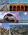
From the top; clockwise: Tocantins River Bridge; Araguaia Palace; Tocantins River; Aerial view of Palmas; Súplica dos Pioneiros monument and Coluna Prestes Memorial.
-
Flag of Palmas.
-

Seal of Palmas.
-
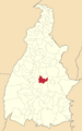
Location of Palmas in Tocantins.
See also
 In Spanish: Palmas (Tocantins) para niños
