Palmyra, Indiana facts for kids
Quick facts for kids
Palmyra, Indiana
|
|
|---|---|
 |
|

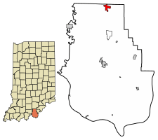
Location of Palmyra in Harrison County, Indiana.
|
|
| Country | United States |
| State | Indiana |
| County | Harrison |
| Township | Morgan |
| Area | |
| • Total | 1.24 sq mi (3.21 km2) |
| • Land | 1.20 sq mi (3.10 km2) |
| • Water | 0.04 sq mi (0.11 km2) |
| Elevation | 774 ft (236 m) |
| Population
(2020)
|
|
| • Total | 898 |
| • Density | 750.84/sq mi (290.00/km2) |
| Time zone | UTC-5 (Eastern (EST)) |
| • Summer (DST) | UTC-4 (EDT) |
| ZIP code |
47164
|
| Area code(s) | 812 |
| FIPS code | 18-57726 |
| GNIS feature ID | 0440849 |
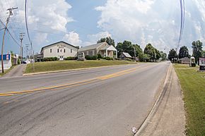
Palmyra is a small town in Morgan Township, Harrison County, Indiana, in the United States. In 2020, about 898 people lived there.
Contents
History of Palmyra
Palmyra was first settled in 1836. It was originally named Carthage. However, there was already another town called Carthage in Indiana. To avoid confusion, the town was renamed Palmyra in 1839. The name likely came from the ancient city of Palmyra.
During the American Civil War, a group of Confederate soldiers visited Palmyra. This happened on the night of July 9, 1863. They were led by Brigadier General John Hunt Morgan. His army had just fought in the Battle of Corydon. The soldiers collected money from local businesses. They also took all the horses in town for their cavalry. The army left Palmyra the next morning, July 10, heading north towards Salem. Before being called Palmyra, the town also had another early name: McClellan's Crossroad.
Geography of Palmyra
Palmyra is located at 38°24′27″N 86°6′38″W / 38.40750°N 86.11056°W.
According to information from 2010, Palmyra covers a total area of about 1.28 square miles (3.32 square kilometers). Most of this area, about 1.24 square miles (3.21 square kilometers), is land. A small part, about 0.04 square miles (0.10 square kilometers), is water.
Population and People
| Historical population | |||
|---|---|---|---|
| Census | Pop. | %± | |
| 1910 | 252 | — | |
| 1920 | 227 | −9.9% | |
| 1930 | 288 | 26.9% | |
| 1940 | 274 | −4.9% | |
| 1950 | 327 | 19.3% | |
| 1960 | 470 | 43.7% | |
| 1970 | 483 | 2.8% | |
| 1980 | 692 | 43.3% | |
| 1990 | 621 | −10.3% | |
| 2000 | 633 | 1.9% | |
| 2010 | 930 | 46.9% | |
| 2020 | 898 | −3.4% | |
| U.S. Decennial Census | |||
In 2010, there were 930 people living in Palmyra. These people lived in 388 households, and 261 of these were families. The town had about 750 people per square mile (290 people per square kilometer).
Most of the people in Palmyra were White (96.1%). A small number were Asian (1.6%) or from two or more races (1.9%). About 1% of the population was Hispanic or Latino.
The average age of people in Palmyra was 37.4 years old. About 24.2% of residents were under 18 years old. About 14.4% were 65 years or older. The town had slightly more females (52.0%) than males (48.0%).
Education in Palmyra
Palmyra has a public library. It is a branch of the Harrison County Public Library system.
The public schools in the area are part of the North Harrison Community Schools Corporation. Students living in Palmyra attend Morgan Elementary School for grades Kindergarten through 5th. Morgan Elementary is located just south of the town. After elementary school, students go to North Harrison Middle School and then North Harrison High School. Both the middle and high schools are located in nearby Ramsey.
See also
 In Spanish: Palmyra (Indiana) para niños
 | Charles R. Drew |
 | Benjamin Banneker |
 | Jane C. Wright |
 | Roger Arliner Young |

