
Palominas, Arizona facts for kids
Quick facts for kids
Palominas, Arizona
|
|
|---|---|

San Pedro River
|
|

Location of Palominas in Cochise County, Arizona.
|
|

Palominas, Arizona
Location in Arizona
|
|
| Country | United States |
| State | Arizona |
| County | Cochise |
| Area | |
| • Total | 1.95 sq mi (5.05 km2) |
| • Land | 1.95 sq mi (5.04 km2) |
| • Water | 0.00 sq mi (0.01 km2) |
| Elevation | 4,242 ft (1,293 m) |
| Population
(2020)
|
|
| • Total | 222 |
| • Density | 114.02/sq mi (44.02/km2) |
| Time zone | UTC-7 (MST (no daylight saving time)) |
| ZIP code |
85615
|
| Area code(s) | 520 |
| FIPS code | 04-52230 |
| GNIS feature ID | 2582839 |
Palominas is a small community in Arizona, United States. It's located in the southern part of Cochise County, right next to the San Pedro River. Palominas is very close to another community called Miracle Valley. You can find it along Arizona State Highway 92. In 2020, about 222 people lived in Palominas.
Life in Palominas
Palominas is a "census-designated place." This means it's an area that looks like a town but doesn't have its own local government. The U.S. Census Bureau defines these areas for counting people.
How People Live Here
The community is quite small. Most people living in Palominas are White (about 77%). There are also people from other backgrounds, including Black or African American, Native American, Asian, and Pacific Islander. About 20% of the people in Palominas are of Hispanic or Latino heritage.
Getting Around Palominas
Even though it's a small place, Palominas has public transportation. The Cochise Connection bus service helps people travel. You can catch a bus from Palominas to nearby towns. These towns include Douglas, Bisbee, and Sierra Vista.
Gallery
-
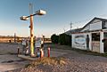
Old Abandoned Palominas Trading Post
-
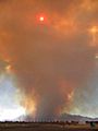
Monument Fire from Palominas, AZ on June 14, 2011


See also
 In Spanish: Palominas (Arizona) para niños
