
Panchagarh District facts for kids
Quick facts for kids
Panchagarh
পঞ্চগড়
|
|
|---|---|

Location of Panchagarh in Bangladesh
|
|
| Country | |
| Division | Rangpur Division |
| Established | 1 February, 1984 |
| Area | |
| • Total | 1,404.62 km2 (542.33 sq mi) |
| Population
(2011 census)
|
|
| • Total | 987,644 |
| • Density | 703.1396/km2 (1,821.123/sq mi) |
| Literacy rate | |
| • Total | 51.08% (male 55.2%, female 48.3%) |
| Time zone | UTC+06:00 (BST) |
| Postal code |
5000
|
Panchagarh (Bengali: পঞ্চগড়, meaning "five forts") is a district in the Rangpur Division of Bangladesh. It is located in the very northern part of the country. This district shares a long border with India on three sides.
Panchagarh covers an area of about 1404.62 square kilometers. Its soil is sandy and alluvial. This means it is made up of sand, silt, and clay left by rivers. The soil is similar to that found near the old Himalayas mountains. You can even find layers of pebbles underground in the northern part of the district.
The district is about 45 meters (150 feet) above sea level. Panchagarh is known for its many rivers, with 16 flowing through it. Some of the main rivers include Karatoya, Atrai, Teesta, Nagor, and Mahananda.
Images for kids
-
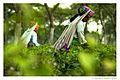
Tea Garden in Panchagarh © Nazmul Hossain Nisad
-
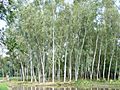
Mirzapur in Panchagarh
-
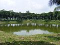
Pond of beside the 12 Auliar Mazar in Panchagarh


See also
 In Spanish: Panchagarh (zila) para niños
