Panola, Illinois facts for kids
Quick facts for kids
Panola
|
|
|---|---|

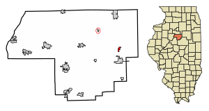
Location of Panola in Woodford County, Illinois.
|
|

Location of Illinois in the United States
|
|
| Country | United States |
| State | Illinois |
| County | Woodford |
| Area | |
| • Total | 0.43 sq mi (1.11 km2) |
| • Land | 0.43 sq mi (1.11 km2) |
| • Water | 0.00 sq mi (0.00 km2) |
| Elevation | 737 ft (225 m) |
| Population
(2020)
|
|
| • Total | 47 |
| • Density | 109.56/sq mi (42.27/km2) |
| Time zone | UTC-6 (CST) |
| • Summer (DST) | UTC-5 (CDT) |
| ZIP Code(s) |
61738
|
| Area code(s) | 309 |
| FIPS code | 17-57524 |
| Wikimedia Commons | Panola, Illinois |
Panola is a very small village located in Woodford County, Illinois, in the United States. It is one of the tiniest communities in Illinois. In 2020, only 47 people lived there. Panola is part of the larger Peoria area. You can find it about 2 miles (3.2 km) north of El Paso, right near Illinois Route 251.
Contents
Panola's History
How Panola Got Its Name
The name "Panola" has an interesting story. Some people thought it was just made up by a railroad official. However, it's actually a Native American word meaning "cotton." The name was given by an official from the Illinois Central Railroad. It was likely named after places like Panola County, Mississippi, or other towns in the southern U.S. that also have the name Panola.
Trying to Unincorporate
In 2004, something unusual happened in Panola. The village leaders tried to "unincorporate" the town. This means they wanted Panola to stop being an official village. Only one other town in Illinois had ever done this before.
At the time, 33 people lived in Panola, and 27 of them could vote. The leaders felt that people weren't very interested in running the local government. So, they held a vote to see if the village should unincorporate. The idea needed more than half of the votes to pass. In the end, 16 people voted against it, and 11 voted for it. So, the village remained Panola!
Geography of Panola
Panola is located at 40°47′6″N 89°1′15″W / 40.78500°N 89.02083°W. This is its exact spot on a map.
According to the 2010 census, Panola covers a total area of about 0.2 square miles (0.52 square kilometers). All of this area is land, meaning there are no lakes or large rivers within the village limits.
Panola's Population
How Many People Live Here?
The number of people living in Panola has changed over the years. Here's a quick look at the population counts from different years:
| Historical population | |||
|---|---|---|---|
| Census | Pop. | %± | |
| 1880 | 127 | — | |
| 1890 | 132 | 3.9% | |
| 1900 | 148 | 12.1% | |
| 1910 | 108 | −27.0% | |
| 1920 | 98 | −9.3% | |
| 1930 | 82 | −16.3% | |
| 1940 | 51 | −37.8% | |
| 1950 | 52 | 2.0% | |
| 1960 | 43 | −17.3% | |
| 1970 | 30 | −30.2% | |
| 1980 | 31 | 3.3% | |
| 1990 | 43 | 38.7% | |
| 2000 | 33 | −23.3% | |
| 2010 | 45 | 36.4% | |
| 2020 | 47 | 4.4% | |
| U.S. Decennial Census | |||
As of the 2010 census, there were 45 people living in Panola. By 2020, the population had grown slightly to 47 residents.
Who Lives in Panola?
In 2010, most of the people living in Panola were non-Hispanic white. One person reported being both black and white, and one person reported being Hispanic or Latino.
In 2000, there were 33 people living in Panola, making up 13 households. Most of these households (84.6%) were married couples living together. A small number (23.1%) of households had children under 18 living with them.
The people in Panola were spread out in terms of age. In 2000:
- 15.2% were under 18 years old.
- 3.0% were between 18 and 24.
- 27.3% were between 25 and 44.
- 30.3% were between 45 and 64.
- 24.2% were 65 years old or older.
The average age in the village was 46 years old.
See also
 In Spanish: Panola (Illinois) para niños
 | Aurelia Browder |
 | Nannie Helen Burroughs |
 | Michelle Alexander |

