
Paradise River waterfalls facts for kids
The Paradise River in Washington state, United States, is famous for its eight main waterfalls. These beautiful falls are found in the Mount Rainier area, offering amazing sights for visitors.
Contents
Paradise Falls
Quick facts for kids Paradise Falls |
|
|---|---|
| Lua error in Module:Infobox_mapframe at line 185: attempt to index field 'wikibase' (a nil value). | |
| Location | Mount Rainier, Pierce County, Washington |
| Type | Segmented Block |
| Total height | 30 feet (9.1 m) |
| Number of drops | 1 |
| Total width | 30 feet (9.1 m) |
| Watercourse | Paradise River |
Paradise Falls is the very first waterfall you'll find on the Paradise River. It's located at 46°47′54″N 121°43′04″W / 46.79833°N 121.71778°W. This waterfall is a "segmented block" type, meaning the water flows over a wide area and then splits into different sections as it drops. It's about 30 feet (9.1 m) tall.
The Skyline Trail crosses the river not far from the falls. However, to protect the natural area, it's important to stay on the marked trails. This means you can enjoy the views from the footbridge, even if they aren't super close up.
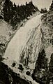
Sluiskin Falls
| Sluiskin Falls | |
|---|---|
.jpg)
Sluiskin Falls, around 1912
|
|
| Lua error in Module:Infobox_mapframe at line 185: attempt to index field 'wikibase' (a nil value). | |
| Location | Mount Rainier, Pierce County, Washington |
| Type | Fan |
| Total height | 180 feet (55 m) |
| Number of drops | 1 |
| Total width | 50 feet (15 m) |
| Watercourse | Paradise River |
Sluiskin Falls, found at 46°47′36″N 121°43′02″W / 46.79333°N 121.71722°W, is the second tallest waterfall on the Paradise River. It's only 8 feet (2.4 m) shorter than Narada Falls. This impressive waterfall is where the river, still quite small, drops into Paradise Valley. The falls are about 180 feet (55 m) high and 50 feet (15 m) wide.
Just like Paradise Falls, it would be easy to get close to the bottom of Sluiskin Falls. But to keep the area safe and natural, visitors must stay on the trails. This means you'll see the falls from a distance.
The falls were named by General Hazard Stevens and Philemon Beecher Van Trump. They honored a local Native American guide named Sluiskin. He helped them with the first climb of Mount Baker back in 1870.
Ruby Falls
| Ruby Falls | |
|---|---|
| Lua error in Module:Infobox_mapframe at line 185: attempt to index field 'wikibase' (a nil value). | |
| Location | Mount Rainier, Lewis County, Washington |
| Type | Tiered |
| Total height | 30 feet (9.1 m) |
| Number of drops | 2 |
| Total width | 20 feet (6.1 m) |
| Watercourse | Paradise River |
Ruby Falls, located at 46°46′42″N 121°44′21″W / 46.77833°N 121.73917°W, is the first major waterfall on the Paradise River after it leaves Paradise Valley. It's sometimes overlooked, but it's a beautiful spot. Ruby Falls has two main sections, or "tiers." First, there's a 15-foot (4.6 m) cascade, which is like a series of small steps. Then, there's a 15-foot (4.6 m) plunge, where the water drops straight down.
There's a bridge built right between these two sections. You can easily see the upper part of the falls from the bridge. To get a good view of the lower part, you can walk about 100 feet (30 m) downstream from the bridge along the Narada Falls Trail.
Washington Cascades
| Washington Cascades | |
|---|---|
| Lua error in Module:Infobox_mapframe at line 185: attempt to index field 'wikibase' (a nil value). | |
| Location | Mount Rainier, Lewis County, Washington |
| Type | Cascade |
| Total height | 100 feet (30 m) |
| Number of drops | 5 |
| Total width | 10 feet (3.0 m) |
| Watercourse | Paradise River |
The Washington Cascades, found at 46°46′41″N 121°44′26″W / 46.77806°N 121.74056°W, are a series of beautiful cascades along the Paradise River. They begin about 200 feet (61 m) downstream from Ruby Falls. These cascades stretch for about 100 yards, dropping a total of 100 feet (30 m). No single drop is taller than 30 feet.
Henry Schwargel named these falls simply after the state of Washington. Sometimes, you might hear them called the Washington Torrents.
Narada Falls
| Narada Falls | |
|---|---|
|
Narada Falls
|
|
| Lua error in Module:Infobox_mapframe at line 185: attempt to index field 'wikibase' (a nil value). | |
| Location | Mount Rainier, Lewis County, Washington |
| Type | Plunge |
| Total height | 188 feet (57 m) |
| Number of drops | 1 |
| Total width | 60 feet (18 m) |
| Watercourse | Paradise River |
Narada Falls is one of the most famous and easily accessible waterfalls on the Paradise River. It's located at 46°46′30″N 121°44′42″W / 46.77500°N 121.74500°W. This waterfall is a stunning 188 feet (57 m) plunge, where the water drops straight down into a pool below. It's also about 60 feet (18 m) wide.
There's a viewing bridge that offers fantastic views of the falls, making it a popular stop for visitors. The name "Narada" comes from a Sanskrit word meaning "pure" or "innocent."
Sidewinder Cascades
| Sidewinder Cascades | |
|---|---|
| Lua error in Module:Infobox_mapframe at line 185: attempt to index field 'wikibase' (a nil value). | |
| Location | Mount Rainier, Lewis County, Washington |
| Type | Cascade |
| Total height | 60 feet (18 m) |
| Number of drops | 3 |
| Total width | 20 feet (6.1 m) |
| Watercourse | Paradise River |
The Sidewinder Cascades, at 46°46′24″N 121°44′58″W / 46.77333°N 121.74944°W, are a series of cascades found a short distance downstream from Narada Falls. These falls drop about 60 feet (18 m) in three different sections, or "tiers." The lowest tier is the biggest, dropping about 25 feet (7.6 m) into a jumble of large rocks.
Madcap Falls
| Madcap Falls | |
|---|---|
| Lua error in Module:Infobox_mapframe at line 185: attempt to index field 'wikibase' (a nil value). | |
| Location | Mount Rainier, Lewis County, Washington |
| Type | Cascade |
| Total height | 25 feet (7.6 m) |
| Number of drops | 1 |
| Total width | 10 feet (3.0 m) |
| Watercourse | Paradise River |
Madcap Falls, located at 46°45′55″N 121°46′02″W / 46.76528°N 121.76722°W, is a smaller cascade about 25-foot (7.6 m) high. It's found a short distance downstream from where Tatoosh Creek joins the Paradise River.
Sometimes, maps have shown Madcap Falls in the wrong places along the river. While some maps suggest it's right at the mouth of Tatoosh Creek, it's been proven there's no waterfall there. There's even a chance that the waterfall we currently call Carter Falls might actually be Madcap Falls, and the real Carter Falls is further downstream.
Carter Falls
| Carter Falls | |
|---|---|
| Lua error in Module:Infobox_mapframe at line 185: attempt to index field 'wikibase' (a nil value). | |
| Location | Mount Rainier, Lewis County, Washington |
| Type | Plunge |
| Total height | 55 feet (17 m) |
| Number of drops | 1 |
| Total width | 10 feet (3.0 m) |
| Watercourse | Paradise River |
Carter Falls, at 46°45′54″N 121°46′07″W / 46.76500°N 121.76861°W, is the last of the major waterfalls along the Paradise River. It's about 55 feet (17 m) tall. The water here plunges 55 feet (17 m) straight down from a narrow opening in the rocks. There's also a small upper section just above the main drop, but its exact height isn't known.
As with Madcap Falls, there's some discussion about whether the waterfall currently known as Carter Falls is actually Madcap Falls, and if the true Carter Falls is located further downstream.
Henry Carter, who built the first trail to the Paradise Valley, named these falls sometime between 1889 and 1900.
Images for kids
-
Sluiskin Falls, around 1912
