
Park Quay facts for kids
Quick facts for kids Park or Fulton's Quay |
|
|---|---|
 |
|
| Location | |
| Country | Scotland |
| Location | Erskine |
| Coordinates | 55°54′18″N 4°26′30″W / 55.904947°N 4.4417902°W |
| Details | |
| Opened | 18th-19th century |
| Operated by | Until 20th century |
| Owned by | Park Estate |
| Type of harbor | Private |
| Available berths | One |
| Piers | One |
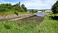
Park Quay or Fulton's Quay is an old, unused dock on the south bank of the River Clyde in Scotland. It's located near Erskine, close to Newshot Island. This quay also has a slipway, which is a ramp for boats. Both the quay and slipway were once connected by roads that ran through the Park Estate.
The quay was first called Fulton's Quay in 1830. This name came from a past owner of the Park Estate, Humphrey Fulton. He might have built the quay before 1801. In 1869, a special light was put at Park Quay to help guide boats.
Contents
Park Quay: A Historic Spot
The Story of Park Estate
The land where Park Quay sits is called the Lands of Park. In the late 1400s, William Park owned this land. Since he had no sons, his daughters inherited it. Over time, the land passed through different families.
In 1768, a family named Campbell bought Park. They made many improvements to the estate and built a large house. Later, in 1789, Humphrey Fulton became the owner. He was a rich businessman who made silk in Paisley. His son, William, then owned the estate.
By 1905, the famous shipbuilder Mr. W.T. Lithgow owned Park. His family's main home was in Langbank. After William Lithgow died in 1908, the woods were cut down. Park House was taken down to make space for the houses you see there today.
How Park Quay Was Built
Old maps help us understand when Park Quay was built. A map from 1755 shows Park House but no quay. Maps from 1800 and 1826 also don't show a quay, only a road to the river. The quay first appears on a map from 1818.
This map shows the quay on the Park Estate. A road from the main house led to it. The name 'Fulton's Quay' suggests it was built for the private use of the Park Estate. This likely happened between 1789 and 1801. Unlike the nearby Rashielee Quay, Park Quay wasn't used for mining.
The quay probably stayed in use until the 1900s. By the late 1930s, maps no longer showed the quay or its beacon. The road to Park House was also shortened.
What Park Quay Looks Like

Park Quay has a dock, a jetty, and a slipway. These were all connected by roads. The dock, or basin, is about 54 meters (177 feet) long and 10 meters (33 feet) wide. One side of the dock is made of small stones. The other side is a ruined wall of larger, well-cut stones.
The main jetty of Park Quay is 70 meters (230 feet) long and 16 meters (52 feet) wide. The eastern part of the jetty is quite damaged. It looks like it partly collapsed at some point. A simple repair was made using wooden poles to hold the loose stones in place. At the southern end, a slipway allowed boats to reach the river when the tide was low.
Changes Over Time

An OS map from 1864 shows a wide jetty with a flag and a small building. It seemed to reach the low water mark of the river. However, the shoreline has changed a lot over the years. This is due to dredging (clearing the riverbed) and building structures like training dikes.
Between 1864 and 1895, a dock or basin was built. It also stretched into the Clyde. The jetty looked damaged on maps, and repairs were made using wooden poles. These poles can still be seen today. In 1857, the eastern jetty might have had a crane. Its end was partly curved and strengthened.
By the 1920s or 1930s, the end of the jetty was changed to a straight shape. In 1905, the quay was still marked as being in use. A beacon, or light, stood nearby to help guide boats. This beacon might have been on a round stone structure. In 1939, the quay was not marked as disused. This was different from the abandoned Rashielee Quay.
Rashielee Quarry was close by. It provided much of the strong whinstone rock. This rock was used to build quays, jetties, and other structures along this part of the Clyde.
The Park Quay Ship Graveyard
Along the River Clyde shoreline, near the Newshot Local Nature Reserve, you can find several old, abandoned boats. These are called mud punts. They are in different states of decay.
These mud punts are lined up, showing where they were left. They were towed here when they were no longer needed. This happened because new ways of dredging the river made them old-fashioned.

Images for kids
-
Park Quay & basin
