Newshot Island facts for kids
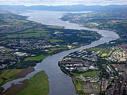
 Newshot Island from the air |
|
| OS grid reference | NS48757011 |
|---|---|
| Coordinates | 55°54′01″N 4°25′14″W / 55.9003°N 4.42068°W |
| Physical geography | |
| Island group | Islands of the River Clyde |
| Area | c.3ha |
| Highest elevation | <3 metres (9.8 ft) |
| Administration | |
| Sovereign state | United Kingdom |
| Country | Scotland |
| Council area | Renfrewshire |
| Demographics | |
| Population | 0 |
Newshot Island was once a small island (about 50 acres or 20 hectares) in the River Clyde in Scotland. It was near Park Quay in Inchinnan, Renfrewshire. Over time, sand and mud built up, connecting it to the southern bank of the river. Today, it is used for grazing animals and is a special place for nature.
The word 'shot' in old Scots language could mean a part of land that sticks out, like a small peninsula. It also meant a place where people used to fish with nets, especially for salmon.
Contents
Islands of the River Clyde
The River Clyde once had several islands, not just sandbanks that appeared at low tide. These islands, moving upstream towards Glasgow, included:
There was also an island called Colin's Isle in the River Cart, close to where it joins the Clyde. The word 'Inch' comes from the Gaelic word 'Innis', which means island. The name 'Ron' in Scots refers to a thick area of hawthorn or rose bushes, like a small, dense forest.
Newshot Island's History

The Palace or Castle of Inchinnan was built around 1506 by the Darnley family. By 1710, much of it was still standing, but by the late 1700s, it had been completely taken down. Some of its stones were used to build a wall on Newshot Island. In 1745, the lands of Inchinnan, including Newshot Island, were given to James Campbell of Blythswood.
The Garnieland farm, which is no longer there, was near the old Inchinnan Palace. It included the lands and islands of Newshot.
Timothy Pont's map from the early 1600s clearly shows a single island called 'Neushot'. By the mid-1600s, 'New-Shot' was recorded near Ron island, across from Inchinnan Castle. In 1800, the island was called 'Nushet', and by 1832, the name 'Newshot' was commonly used.
Some old maps show a smaller island next to the main Newshot Island. By 1896, this smaller island had joined with the southern river bank.
A marker that showed the edge of the Clyde's deep-water channel was on maps in 1846, but it was gone by 1864.
The OS Name Book from 1856-1857 described Newshot Island as a "very remarkable tract of land" that followed the River Clyde for about 1.5 miles. It was bounded on the south by the "Old Channel" of the river. The land was very flat and, except for parts covered at high tide, was considered "very good pasture land" for animals.
Some maps from 1800 show a small building on the island. At one point, it looked like parts of the island were farmed, with hedges or walls. A small raised area on the island might be where the building once stood.
The first connection from the island to Garnieland Farm was a raised path or bridge built around 1800. Later in the 1800s, a second raised path was built. These paths might have changed how the water flowed, causing mud and sand to build up. By 1896, the upstream part of the island was connected to the southern bank. This made the old river channel fill with silt, while the new channel became deep enough for large ships to reach Glasgow. The old river channel was also used to dump mud from dredging the docks in Glasgow.
The island might have the remains of an old fishing weir, which is a fence-like structure built across a river to catch fish. A mooring anchor for a barrage balloon from World War II was also found on the island.
Ship Graveyard
Newshot Island is a protected historical site because it contains the wrecks of several old boats. These include 28 mud punts (flat-bottomed boats used for carrying mud) and an iron-hulled diving support vessel from around 1852. Next to the diving vessel is a square structure. The mud around these wrecks may contain items that were dredged from the River Clyde when its shipping channels were made deeper.
The RMS Queen Mary's Journey
The famous ship RMS Queen Mary briefly touched the ground (or "grounded") on Newshot Island. This happened on March 24, 1936, when the ship was on its first journey down the Clyde after being launched.
Wildlife and Nature Reserve
The Newshot Local Nature Reserve is a 73-hectare area. It is very important because it has salt-marshes, which are wetlands flooded by salty water. It is also a vital place for migratory birds from North America, Siberia, and West Africa to feed and nest.
 | Janet Taylor Pickett |
 | Synthia Saint James |
 | Howardena Pindell |
 | Faith Ringgold |


