
Milton Island facts for kids
 River Clyde near Milton Island |
|
| OS grid reference | NS 42651 73794 |
|---|---|
| Coordinates | 55°55′53″N 4°31′13″W / 55.931381°N 4.5202637°W |
| Physical geography | |
| Island group | Islands of the River Clyde |
| Area | 1.852 acres (7,495 m2) in 1905 |
| Highest elevation | <3 metres (9.8 ft) |
| Administration | |
| Sovereign state | United Kingdom |
| Country | Scotland |
| Council area | Dunbartonshire |
| Demographics | |
| Population | 0 |
Milton Island, also known as Green Inch, was once an island in the River Clyde. It was located near Dumbuck, close to Dumbarton. This island was part of an old river crossing, or ford, which some believe was built by the Romans. Over time, changes in the river due to human activity have made the island much smaller. Today, it has even split into several tiny islets.
Contents
Islands of the River Clyde
The River Clyde once had many islands, not just sandbanks that appear at low tide. If you traveled upstream towards Glasgow, you would have seen islands like Bodinbo, Newshot, Ron, Sand Inch, King's Inch, Buck Inch, White Inch, and Water Inch. Colin's Isle was also nearby, where the Cart Water joins the Clyde.
The word 'Inch' comes from the Scots language. It means "island" and comes from the old Gaelic word 'Innis'.
Milton Island's Location and History
Milton Island was found between Dumbarton and Dunglass Castle, below Dumbuck Hill. On a map from 1747-55 by William Roy, it was called 'Green Inch'. By 1821, it was known as Millton Island, named after the nearby village.
In 1860, official records described Milton Island as "An Island in the foreshore of the Clyde at Milton from which it is named. It is never covered at High Water above the H.W.M. [High Water Mark] shewn." This means it was always above the water, even at high tide.
An old oil terminal upstream from Milton Island has changed how the river moves sand and soil. Because of this, Milton Island is no longer a single island. As of 2018, it exists as three small grassy islets within the area where the old island used to be. The Dumbuck Perch, a slightly raised area with stones, is also nearby.
The Ancient Dumbuck Ford
The River Clyde at Dumbuck was shallow enough to be crossed on foot or horseback when the tide was low. It is believed that the Romans built a causeway, which is like a raised road, about 7 meters (23 feet) wide. This causeway helped people cross the river. It supposedly ran from Longhaugh, curved through the river, and continued as a low mound towards the beach.
The causeway then crossed Milton Island and continued towards Dumbarton road. On the south side of the river, it is thought to have gone towards Bishopton Fort. The Romans needed this path to connect their fort with the Antonine Wall, which reached at least as far as Old Kilpatrick.
While this ford was useful for crossing the river, the shallow water meant that large ships could not reach Glasgow. This was the lowest point on the River Clyde where you could cross by foot. Glasgow was the lowest point where a bridge could be built.
The Dumbuck Shoal, a large sandbank, made it hard to make the river deeper for ships. In the late 1500s and early 1600s, people tried to remove this sandbank but had little success. They built jetties, which are structures that stick out into the water, to try and make the river flow faster and wash away the sand. But this didn't help much.
The Dumbuck Shoal remained a big problem: "The first and grand obstacle is Dumbuck Ford... where, the river dividing itself into two channels, the reflowing current is greatly weakened, and the bottom, being covered with a crust of hard gravel, cannot be worn down to the proper depth."
To fix this, the original 'Lang Dyke' was built in 1773. Stones from the Rashielee Quarry were used to build it. This project eventually led to the removal of the Dumbuck Ford, which greatly improved navigation for ships traveling to Glasgow.
In the Scots language, 'Buck' means a place where water gushes out, and 'Dum' refers to a fort, like in Dumbarton.
Archaeological Discoveries
To the west of Milton Island, there is a famous pre-Roman structure called the Dumbuck crannog. A crannog is an ancient dwelling, often built on an artificial island in a lake or river. Excavations showed that this timber round house was built on layers of brushwood, earth, and stone. Large wooden piles held it in place and made it strong. A small dock for a log-boat was also found, and it still contained a log-boat!
In 1868, an oak dug-out canoe was discovered near Milton Island. It was about 6.7 meters (22 feet) long and 0.9 meters (2 feet 10 inches) wide. Inside the canoe, archaeologists found deer horn, six stone axe heads, and what might have been a paddle.
Images for kids
-
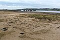
View from Milton Island
-
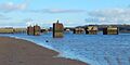
Bollards on the River Clyde
-
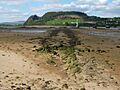
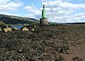
The Dumbuck Perch
-
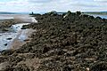
Suggested remnants of the paved Roman ford looking towards Dumbuck Hill
-
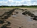
Suggested remnants of the Roman paved ford
-
The Lang Dyke
-
The Lang Dyke (Erskine Bridge in background)
-

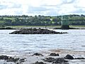
Dumbuck Crannog and Dumbuck Hill

.jpg)

.jpg)
.jpg)
.jpg)
.jpg)

