King's Inch facts for kids
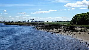
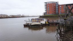 King's Inch and the Ferry Village from the Renfrew Ferry |
|
| OS grid reference | NS513674 |
|---|---|
| Coordinates | 55°52′34″N 4°22′41″W / 55.876°N 4.378°W |
| Physical geography | |
| Island group | Islands of the River Clyde |
| Administration | |
| Sovereign state | United Kingdom |
| Country | Scotland |
| Council area | Renfrewshire |
| Demographics | |
| Population | 0 |
King's Inch and the smaller Sand Inch were once islands in the River Clyde near Renfrew, Scotland. Over time, due to river changes and building work, they are now part of the mainland. You can still find the name "King's Inch" in street names, and there was even a King's Inch railway station for a while.
The name "Inch" comes from the Scots word, which means "island" in Scottish Gaelic. These islands were known as "Royal lands" because they belonged to King Robert II and later Stewart kings.
Contents
Islands in the River Clyde
The River Clyde once had several islands, not just sandbanks that appeared at low tide. Moving upstream towards Glasgow, these islands included Milton, Bodinbo, Newshot, Ron, Sand Inch, Kings Inch, Buck Inch, White Inch and Water Inch. There was also a Colin's Isle near where the River Cart meets the Clyde.
The name 'Ron' in Scots means a thicket of hawthorns or rose bushes. It describes an area of small, crowded trees.
Sand Inch
Sand Inch was a small island located downstream from King's Inch. It appeared on maps from the late 16th century. However, by the mid-17th century, later maps no longer showed it as a separate island. Sand Inch eventually joined with the river bank and became part of King's Inch.
King's Inch
King's Inch was a large island off the River Clyde at Renfrew. It stopped being an island sometime after the mid-18th century. It may have first joined with Sand Inch, and then later with the mainland. It might also have joined with another nearby islet called Buck Inch.
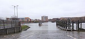
The Renfrew Ferry service originally started from King's Inch. However, in 1778, it was decided to move the ferry closer to Renfrew town. This move also helped prevent people from walking through the private land of the Elderslie Estate. The new ferry road, house, and docks were finished by 1791.
Castles on King's Inch
Walter fitz Alan, who was the Steward of Scotland during the reign of King David I (1124-1153), built the first castle on King's Inch in the 12th century. This castle was likely made mostly of wood with stone foundations. It sat on an earth mound (called a motte) and was surrounded by a moat filled with water.
This castle helped Walter protect King David I's land in this area. In 1164, Somerled, the King of the Isles, arrived with 160 ships in the Firth of Clyde. He was a threat to the kingdom. However, his invasion failed, and Somerled was killed in a battle near Renfrew.
The castle on King's Inch was no longer used in the 13th century. A new stone castle was built instead, in what is now the center of Renfrew.
Later, in the 15th century, Sir John Ross was given the 'Lands of Inch,' which included the ruins of the first castle. He built a new castle called Inch Castle on the same spot. This was a three-story stone building. By 1791, Inch Castle had been taken down. King James IV made Sir John Ross the permanent constable (in charge) of the original castle.
King's Inch and Paisley Abbey
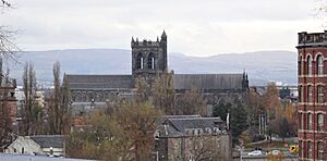
Around 1168, thirteen monks from Much Wenlock came to Renfrew. They stayed at the Steward's castle on King's Inch, where there was a church dedicated to Saints Mary and James. Their new home at Paisley Abbey wasn't ready yet. The monks were allowed to fish in the River Clyde.
By 1172, the monks had moved to Paisley Abbey. Walter gave King's Inch and all the fishing rights on the Clyde between the island and Partick to the abbey. The island belonged to Paisley Abbey until 1208–1213. At that time, the abbey traded the island back to Walter's grandson for other lands.
The Story of Sir John Ross
There's an old story about how Sir John Ross got King's Inch. It's said that the King of England challenged Scotland to find a man to fight his champion. The King of Scotland offered King's Inch as a reward to anyone who could win. Sir John Ross of Hawkhead, who was small but very strong and agile, offered to fight.
He wore a tight, greasy animal skin, making him very slippery. The English champion couldn't get a grip on him. Finally, the Englishman held out his hands, inviting Ross to grab them. Ross seized his wrists and, with a sudden pull, dislocated his arms. Sir John Ross won the fight.
The King tried to offer Sir John other land instead, but Sir John insisted on the Inch and its castle. From then on, he was known as "Palm-my-arm."
Elderslie House
In 1760, Mr. Andrew Speirs, a wealthy merchant, bought the lands of King's Inch. He later built Elderslie House in 1777, a large four-story mansion. It was designed by a famous architect named Robert Adam. The house was built using some stones from the old 15th-century Inch Castle.
By 1859, the name King's Inch was still used for the Elderslie Estate. The estate's border followed the Pudzeoch Burn near the Renfrew Ferry and went upstream along the River Clyde. Elderslie House was taken down in 1924.
Braehead Power Station and Shopping Centre
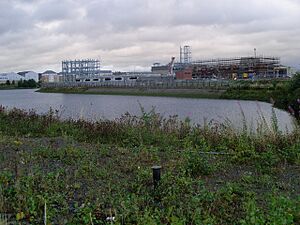
After Elderslie House was demolished, the land was sold. In 1951, Braehead Power Station was built there. It was one of the first power stations built after World War II. The power station was taken down in the early 1980s. Today, the site of the old island is home to houses and the large Braehead shopping and leisure complex. Nothing remains of the old castles or the estate.
The River Clyde's Changing Course
In the 17th century, the River Clyde flooded and changed its path. Before this, the main current of the river flowed south of King's Inch, right in front of the Renfrew Castle on the mainland. This area is now partly where the Pudzeoch Burn runs.
Later, in the 18th and 19th centuries, the river was extensively dredged (deepened). These changes caused King's Inch to finally join with the mainland.
Maps from different centuries show how the island changed. A late 16th-century map by Timothy Pont shows King's Inch with channels of the Clyde on both sides and a large castle. By 1745, Herman Moll's map shows only a small channel on the south side, and no buildings. William Roy's map from the mid-18th century also shows a small channel separating the island from the south bank. Ross's 1773 map still marks Inch Castle and a nearby Inch House.
 | Roy Wilkins |
 | John Lewis |
 | Linda Carol Brown |


