Parklands, Tasmania facts for kids
Quick facts for kids ParklandsBurnie, Tasmania |
|||||||||||||||
|---|---|---|---|---|---|---|---|---|---|---|---|---|---|---|---|

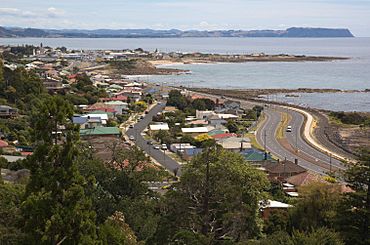
Coast and Bass Highway
|
|||||||||||||||
| Population | 850 (2016 census) | ||||||||||||||
| Postcode(s) | 7320 | ||||||||||||||
| Location | 3 km (2 mi) NW of Burnie | ||||||||||||||
| LGA(s) | City of Burnie | ||||||||||||||
| Region | North-west and west | ||||||||||||||
| State electorate(s) | Braddon | ||||||||||||||
| Federal Division(s) | Braddon | ||||||||||||||
|
|||||||||||||||
Parklands is a suburb where people live in the city of Burnie, Tasmania. It is located in the north-west part of Tasmania. Parklands is about 3 kilometers (2 miles) north-west of the main town of Burnie. In 2016, a count of the population showed that about 850 people lived in Parklands.
Contents
Discover Parklands, Burnie
Parklands is a friendly suburb in north-west Tasmania. It is part of the larger Burnie area. This area has many interesting places to visit and things to do.
The Makers' Workshop
The Makers' Workshop is a special place in Burnie. It celebrates the history of the city. It also honors local artists and people who create things. You can learn about how paper and cheese are made here. There are workshops where you can try these crafts yourself. The Makers' Workshop also has a gallery to see art. Plus, there is a cafe where you can grab a snack.
Burnie War Memorial
The Burnie War Memorial is a monument. It remembers the soldiers who died in the First World War. This memorial helps us honor their bravery and sacrifice.
Burnie Park Fun
Burnie Park is a great spot for families and friends. It has lots of green lawns, perfect for picnics. The park also features a fun playground for kids. You can see a beautiful waterfall there. There is even a music shell, which is a stage for performances.
North West Regional Hospital
The North West Regional Hospital is an important building in Parklands. It is located on Brickport Road. This hospital provides medical care for people in the region.
History of Parklands
Parklands officially became a recognized locality in 1966. This means it was given its name and boundaries that year.
Geography of Parklands
The northern edge of Parklands meets the waters of Bass Strait. This is a large body of water that separates Tasmania from mainland Australia.
Getting Around Parklands
Route A2, also known as the Bass Highway, runs through Parklands. This major road helps people travel from the north-east to the north-west of the area.
Education in Parklands
- Marist Regional College is a school located in Parklands. It provides education for students in the area.


