Patleyna Glacier facts for kids
Quick facts for kids Patleyna Glacier |
|
|---|---|

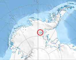
Location of Sentinel Range in Western Antarctica
|
|
| Type | tributary |
| Location | Ellsworth Land |
| Coordinates | 78°03′50″S 85°47′20″W / 78.06389°S 85.78889°W |
| Length | 3.4 nautical miles (6.3 km; 3.9 mi) |
| Width | 1.5 nautical miles (2.8 km; 1.7 mi) |
| Thickness | unknown |
| Terminus | Embree Glacier |
| Status | unknown |
Patleyna Glacier (which is lednik Patleyna in Bulgarian) is a large river of ice in Antarctica. It is about 3.4 nautical miles (6.3 km; 3.9 mi) long and 1.5 nautical miles (2.8 km; 1.7 mi) wide. This glacier is found in the Ellsworth Mountains, which are part of the Sentinel Range.
It flows from the eastern slopes of a mountain called Mount Todd. It also gets ice from the northern slopes of Chepino Saddle. The glacier moves towards the north-northwest. Eventually, it joins another glacier called Embree Glacier. This meeting point is near Mount Goldthwait and Oreshak Peak.
About Patleyna Glacier
A glacier is like a very slow-moving river made of ice. Patleyna Glacier is located in a very cold place. It is in the western part of Antarctica. This area is known as Ellsworth Land.
The glacier is named after a special place in Bulgaria. This place is a nature reserve called Patleyna. It is located in Northeastern Bulgaria.
Where is Patleyna Glacier?
Patleyna Glacier is located at 78°03′50″S 85°47′20″W / 78.06389°S 85.78889°W. This is a very specific spot on the map.
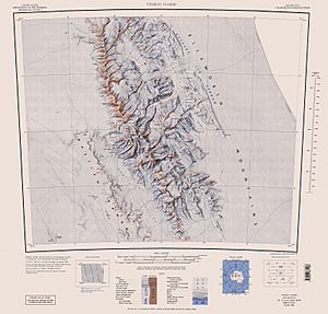
Maps of this area were first made in 1961 by the United States. These maps were later updated in 1988. They help us understand where the glacier is.
 | Jessica Watkins |
 | Robert Henry Lawrence Jr. |
 | Mae Jemison |
 | Sian Proctor |
 | Guion Bluford |


