Paxico, Kansas facts for kids
Quick facts for kids
Paxico, Kansas
|
|
|---|---|

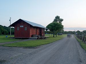
Old railroad depot in Paxico (2009)
|
|

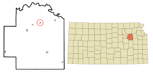
Location within Wabaunsee County and Kansas
|
|

|
|
| Country | United States |
| State | Kansas |
| County | Wabaunsee |
| Founded | 1879 |
| Incorporated | 1914 |
| Named for | Pashqua |
| Government | |
| • Type | Mayor–Council |
| Area | |
| • Total | 0.14 sq mi (0.38 km2) |
| • Land | 0.14 sq mi (0.38 km2) |
| • Water | 0.00 sq mi (0.00 km2) |
| Elevation | 991 ft (302 m) |
| Population
(2020)
|
|
| • Total | 210 |
| • Density | 1,500/sq mi (553/km2) |
| Time zone | UTC-6 (CST) |
| • Summer (DST) | UTC-5 (CDT) |
| ZIP code |
66526
|
| Area code | 785 |
| FIPS code | 20-54950 |
| GNIS ID | 2396166 |
Paxico is a small city in Wabaunsee County, Kansas, in the United States. In 2020, about 210 people lived there. It's a quiet place with a rich history, especially linked to railroads and Native American heritage.
Contents
History of Paxico
Paxico was first called Strong Mill. It was started in 1879 about a mile east of where the city is today. A post office was opened and given the name Paxico. This name honored Pashqua, a Potawatomi medicine man.
In 1886, a railroad was built through the area. The town then moved to be right next to the new railroad tracks. This made it easier for people and goods to travel.
Railroad Connections
In 1887, the Chicago, Kansas and Nebraska Railway built a main line. This line connected Topeka to Herington, passing through Paxico. Over the years, this railroad changed hands many times.
It was taken over by the Chicago, Rock Island and Pacific Railway. Even today, many local people still call this railroad the "Rock Island."
Geography of Paxico
Paxico is a small city, covering about 0.14 square miles (0.38 square kilometers). All of this area is land. It is located in the state of Kansas.
Understanding Paxico's Population
| Historical population | |||
|---|---|---|---|
| Census | Pop. | %± | |
| 1920 | 249 | — | |
| 1930 | 261 | 4.8% | |
| 1940 | 237 | −9.2% | |
| 1950 | 196 | −17.3% | |
| 1960 | 276 | 40.8% | |
| 1970 | 216 | −21.7% | |
| 1980 | 168 | −22.2% | |
| 1990 | 174 | 3.6% | |
| 2000 | 211 | 21.3% | |
| 2010 | 221 | 4.7% | |
| 2020 | 210 | −5.0% | |
| U.S. Decennial Census | |||
Paxico is part of the larger Topeka Metropolitan Statistical Area. This means it's connected to the bigger city of Topeka.
What the 2020 Census Shows
The 2020 United States census counted 210 people living in Paxico. There were 81 households and 55 families. Most people living in Paxico were white or European American. Some people were from other backgrounds or had mixed heritage.
About 37% of the households had children under 18 years old. Many households were married couples. The average age of people in Paxico was about 40.7 years.
What the 2010 Census Shows
The census in 2010 found 221 people living in Paxico. There were 85 households. About 91% of the people were white. A small number were African American or Native American. Some people were of Hispanic or Latino background.
In 2010, about 35% of households had children under 18. The average age of people in the city was 36.3 years.
Education in Paxico
The public schools in Paxico are part of the Wabaunsee USD 329 school district. This district was created by combining schools from Alma, Maple Hill, McFarland, and Paxico.
Wabaunsee High School is located in Alma. The school's mascot is the Wabaunsee Chargers. Paxico used to have its own high school. It was called Paxico High School, and its mascot was the Paxico Pirates.
Fun Events in Paxico
Paxico hosts a couple of fun events each year:
- The Paxico Meatloaf Festival and Car Show happens on the fourth Saturday in June.
- The Paxico Blues Fest is held on the third Saturday in September.
See also
 In Spanish: Paxico (Kansas) para niños


