Payette Lake facts for kids
Quick facts for kids Payette Lake |
|
|---|---|

Panoramic view from McCall
|
|
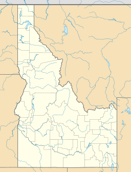
| Location | Valley County, Idaho, U.S. |
| Coordinates | 44°57′N 116°05′W / 44.95°N 116.09°W |
| Primary inflows | North Fork Payette River |
| Primary outflows | North Fork Payette River |
| Catchment area | 144 square miles (373 km2) |
| Basin countries | United States |
| Max. length | 6 miles (9.7 km) |
| Max. width | 2.25 miles (3.62 km) |
| Surface area | 4,986.7 acres (2,018.0 ha) |
| Average depth | 121 feet (36.8 m) |
| Max. depth | 304 feet (92.7 m) |
| Water volume | 0.18 cubic miles (0.75 km3) |
| Shore length1 | 22 miles (36 km) |
| Surface elevation | 4,990 feet (1,520 m) |
| Settlements | McCall, Idaho |
| 1 Shore length is not a well-defined measure. | |
Payette Lake is a beautiful natural lake located in the western United States. You can find it in southwestern Idaho, right next to the town of McCall. This lake was formed a very long time ago by huge sheets of ice called glaciers. It sits at the top of the area that drains into the Payette River, which then flows into the much larger Snake River.
A small dam was finished in 1943 to help control the water flowing out of the lake. This water is used to help farmers water their crops. The lake's water level is usually highest in July, reaching about 1,520 meters (4,987 feet) above sea level. By December, the water level usually drops by about 1.7 meters (5.6 feet).
Contents
About Payette Lake
Payette Lake covers an area of about 20.5 square kilometers (7.9 square miles). It holds about 0.75 cubic kilometers (0.18 cubic miles) of water. The lake's average depth is 36.8 meters (121 feet), but its deepest point goes down to 92.7 meters (304 feet)! The shoreline around the lake is about 36 kilometers (22 miles) long.
The main river that flows into and out of Payette Lake is called the North Fork Payette River. The lake gets its water from a large area of mountains and forests, covering about 373 square kilometers (144 square miles). Further south, the North Fork Payette River flows into Lake Cascade, which is a man-made lake created by a dam.
A Look Back in Time: History of Payette Lake
For thousands of years before European settlers arrived in the 1830s, Native American people lived around Payette Lake. They were the first inhabitants of this beautiful area.
Gold Rush and Early Settlements
In 1862, gold was discovered in the mountains near Payette Lake. This discovery brought many miners to the area, hoping to find their fortune. The town of McCall was started on the southern shore of the lake in the 1880s.
Growing Popularity and Recreation
Getting to McCall became much easier in 1914 when a railroad and new roads were built. This helped McCall become a popular place for people to visit for fun, both in summer and winter.
In 1920, the Idaho State Land Board began renting out spots around Payette Lake where people could build vacation homes. As more and more people wanted to enjoy the outdoors, new places for recreation were created. These included the Brundage Mountain Ski Area and Ponderosa State Park, both near McCall, which opened in the 1960s.
A large building called the Payette Lakes Club was very important for recreation in the area. It was built between 1914 and 1915 on a hill overlooking the lake. This club served as an inn (like a hotel), a casino, and a place for educational talks and performances. Many small cabins were built around it.
 | Tommie Smith |
 | Simone Manuel |
 | Shani Davis |
 | Simone Biles |
 | Alice Coachman |


