
Pemberton, New Jersey facts for kids
Quick facts for kids
Pemberton, New Jersey
|
|
|---|---|
|
Borough
|
|

Center of the Borough of Pemberton
|
|

Pemberton Borough highlighted in Burlington County. Inset map: Burlington County highlighted in the State of New Jersey.
|
|

Census Bureau map of Pemberton, New Jersey
|
|

Pemberton, New Jersey
Location in Burlington County, New Jersey

Pemberton, New Jersey
Location in New Jersey

Pemberton, New Jersey
Location in the United States
|
|
| Country | |
| State | |
| County | Burlington |
| Incorporated | December 15, 1826 |
| Government | |
| • Type | Borough |
| • Body | Borough Council |
| Area | |
| • Total | 0.61 sq mi (1.57 km2) |
| • Land | 0.59 sq mi (1.53 km2) |
| • Water | 0.02 sq mi (0.04 km2) 2.79% |
| Area rank | 540th of 565 in state 39th of 40 in county |
| Elevation | 36 ft (11 m) |
| Population
(2020)
|
|
| • Total | 1,371 |
| • Estimate
(2023)
|
1,376 |
| • Rank | 518th of 565 in state 36th of 40 in county |
| • Density | 2,325.2/sq mi (897.8/km2) |
| • Density rank | 268th of 565 in state 13th of 40 in county |
| Time zone | UTC−05:00 (Eastern (EST)) |
| • Summer (DST) | UTC−04:00 (Eastern (EDT)) |
| ZIP Code |
08068
|
| Area code(s) | 609 exchanges: 726, 894 |
| FIPS code | 3400557480 |
| GNIS feature ID | 0885346 |
| Website | |
Pemberton is a small town called a borough in Burlington County, New Jersey. It's a part of the larger Philadelphia area. In 2020, about 1,371 people lived there.
Pemberton became an official borough on December 15, 1826. It was named after James Pemberton, who owned land in the area. Pemberton is known as a dry community, which means that selling alcohol is not allowed there. This rule was last confirmed by a vote in 1980.
Contents
Where is Pemberton Located?
Pemberton is quite small, covering about 0.61 square miles (1.57 square kilometers). Most of this area is land, with a small amount of water.
An interesting fact about Pemberton is that it's completely surrounded by Pemberton Township. This makes it one of 21 "doughnut towns" in New Jersey, where one town completely wraps around another!
Who Lives in Pemberton?
| Historical population | |||
|---|---|---|---|
| Census | Pop. | %± | |
| 1870 | 797 | — | |
| 1880 | 799 | 0.3% | |
| 1890 | 834 | 4.4% | |
| 1900 | 771 | −7.6% | |
| 1910 | 797 | 3.4% | |
| 1920 | 800 | 0.4% | |
| 1930 | 783 | −2.1% | |
| 1940 | 906 | 15.7% | |
| 1950 | 1,194 | 31.8% | |
| 1960 | 1,250 | 4.7% | |
| 1970 | 1,344 | 7.5% | |
| 1980 | 1,198 | −10.9% | |
| 1990 | 1,367 | 14.1% | |
| 2000 | 1,210 | −11.5% | |
| 2010 | 1,409 | 16.4% | |
| 2020 | 1,371 | −2.7% | |
| 2023 (est.) | 1,376 | −2.3% | |
| Population sources: 1870–2000 1870–1920 1870 1880–1890 1890–1910 1910–1930 1940–2000 2000 2010 2020 |
|||
In 2010, there were 1,409 people living in Pemberton. The population has changed a bit over the years, but it usually stays around 1,200 to 1,400 people. The people living in Pemberton come from many different backgrounds.
A Look Back in Time: Pemberton's History
|
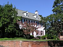
Pemberton Historic District
|
|
.JPG)
Houses on Hanover Street
|
|
| Location | Portions of Budd Avenue; Early Alley; Jarvis, Hanover, Hough, Egbert, Davis, Mary, Antis, Elizabeth, Early, Pemberton, Jane, Reeves, Reynolds, and St. John streets |
|---|---|
| Area | 94 acres (38 ha) |
| Architectural style | Classical Revival, Late Victorian, Federal |
| NRHP reference No. | 88000688 |
| Significant dates | |
| Added to NRHP | March 22, 1989 |
Pemberton has a special historic district that covers 94 acres. This area was added to the National Register of Historic Places in 1989 because of its important history, old buildings, and how the town was settled. It has 180 buildings that are considered historically important.
Two old churches are part of this history:
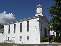
- The First Baptist Church started in 1752. The building you see today was built in 1861 in the Greek Revival style, which looks like ancient Greek temples.
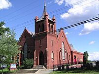
- The Methodist Church was founded in 1774, making it one of the oldest in New Jersey. The current church building was built in 1895.
-
Morris Mansion and Mill
-
First Baptist Church
-
United Methodist Church
.JPG)
.JPG)
.JPG)
Learning in Pemberton
Students from Pemberton Borough go to schools in the Pemberton Township School District. This district serves students from both Pemberton Borough and Pemberton Township. The state helps pay for school building projects in this district.
The district has nine schools for students from pre-kindergarten all the way through high school.
- Pemberton Early Childhood Education Center (PreK)
- Samuel T. Busansky Elementary School (Grades 3–5)
- Denbo-Crichton Elementary School (Grades K–5)
- Howard L. Emmons Elementary School (Grades K–2)
- Fort Dix Elementary School (Grades PreK–5)
- Joseph S. Stackhouse Elementary School (Grades K–2)
- Marcus Newcomb Middle School (Grade 6)
- Helen A. Fort Middle School (Grades 7–8)
- Pemberton Township High School (Grades 9–12)
For students interested in learning a trade or special skills, the Burlington County Institute of Technology offers vocational and technical programs. It has campuses in Medford and Westampton.
Getting Around Pemberton
_at_Burlington_County_Route_616_(Hanover_Street)_in_Pemberton,_Burlington_County,_New_Jersey.jpg)
Pemberton has about 8.81 miles of roads. The most important road that goes through the borough is County Route 530.
For public transportation, NJ Transit buses run on route 317, connecting Pemberton to places like Asbury Park and Philadelphia. There's also a local bus service called BurLink on the B1 route, which goes between Beverly and Pemberton.
Famous Faces from Pemberton
Many interesting people have connections to Pemberton:
- Jeff Celentano (born 1960) is an actor and director.
- George Franklin Fort (1808–1872) was the 16th Governor of New Jersey.
- John Franklin Fort (1852–1920) was also a Governor of New Jersey, serving from 1908 to 1911.
- Bushrod W. Lott (1826–1886) was a politician who served as a United States Consul in Mexico.
- Rex Marshall (1919–1983) was a well-known actor and TV announcer.
- Isaac Witkin (1936–2006) was a famous sculptor.
See also
 In Spanish: Pemberton (Nueva Jersey) para niños
