
Pennsylvania Route 274 facts for kids
Quick facts for kids
|
||||
|---|---|---|---|---|
| Lua error in Module:Infobox_road/map at line 15: attempt to index field 'wikibase' (a nil value). | ||||
| Route information | ||||
| Maintained by PennDOT | ||||
| Length | 43.8 mi (70.5 km) | |||
| Major junctions | ||||
| West end | ||||
| East end | ||||
| Location | ||||
| Counties: | Franklin, Perry | |||
| Highway system | ||||
| Roads in Pennsylvania Interstate • US • State • Legislative
|
||||

Pennsylvania Route 274 (PA 274) is a special road in Pennsylvania. It helps people travel across Franklin and Perry Counties. This road is about 44 miles long. That's like driving from one end of a big city to the other!
PA 274 starts in Fannett Township at Pennsylvania Route 75. It then travels east. The road ends in Duncannon. There it meets US 11 and US 15. Think of it as an important path connecting different towns. It helps people get where they need to go.
What is a State Highway?
A state highway like PA 274 is a road. The state government helps to build and take care of it. These roads are important. They connect cities, towns, and rural areas. They help people travel for work, school, and fun. State highways also help businesses move goods. This makes them a key part of how our communities work every day.
Journey Through Pennsylvania
PA 274 travels through two counties. These are Franklin County and Perry County. As you drive along PA 274, you might see different landscapes. You could see farms, small towns, and natural areas. The road connects several smaller communities. These include Blain, Tyrone Township, and Elliottsburg. It also passes through Bloomfield. This journey shows you a part of Pennsylvania's countryside.
Images for kids
-
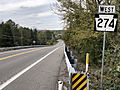
PA 274 westbound in Wheatfield Township
_at_Linton_Hill_Road_in_Wheatfield_Township,_Perry_County,_Pennsylvania.jpg)
