Peoria, Colorado facts for kids
Quick facts for kids
Peoria, Colorado
|
|
|---|---|

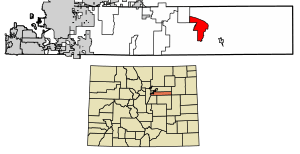
Location of the Peoria CDP in Arapahoe County, Colorado.
|
|
| Country | |
| State | |
| County | Arapahoe County |
| Government | |
| • Type | unincorporated community |
| Area | |
| • Total | 13.804 sq mi (35.753 km2) |
| • Land | 13.765 sq mi (35.650 km2) |
| • Water | 0.040 sq mi (0.103 km2) |
| Elevation | 5,272 ft (1,607 m) |
| Population
(2020)
|
|
| • Total | 153 |
| • Density | 11.08/sq mi (4.279/km2) |
| Time zone | UTC-7 (MST) |
| • Summer (DST) | UTC-6 (MDT) |
| ZIP Code |
Byers 80103
|
| Area codes | 303 & 720 |
| GNIS feature | Peoria CDP |
Peoria is a small community in Arapahoe County, Colorado, United States. It is known as an unincorporated community, which means it doesn't have its own local government like a city or town. Instead, it is managed by the county.
Peoria is also a census-designated place (CDP). This is a special area defined by the government just for counting people during a census. It helps keep track of how many people live there. Peoria is part of the larger Denver–Aurora–Lakewood, CO Metropolitan Statistical Area. In 2020, about 153 people lived in Peoria. The local post office for the area is in Byers, Colorado, with ZIP code 80103.
Geography of Peoria
Peoria covers an area of about 35.75 square kilometers (or 13.8 square miles). Most of this area is land, with a very small part, about 0.1 square kilometers, being water.
Population and Demographics
The United States Census Bureau is the group that counts the population in the U.S. They first counted Peoria as a census-designated place for the United States Census 2010.
Here's how the population of Peoria has changed:
| Peoria CDP, Colorado | ||
|---|---|---|
| Year | Pop. | ±% |
| 2010 | 163 | — |
| 2020 | 153 | −6.1% |
| Source: United States Census Bureau | ||
See also
- In Spanish: Peoria (Colorado) para niños


