Peoria, Oklahoma facts for kids
Quick facts for kids
Peoria, Oklahoma
|
|
|---|---|

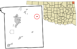
Location within Ottawa County and the state of Oklahoma
|
|
| Country | United States |
| State | Oklahoma |
| County | Ottawa |
| Area | |
| • Total | 0.24 sq mi (0.63 km2) |
| • Land | 0.24 sq mi (0.63 km2) |
| • Water | 0.00 sq mi (0.00 km2) |
| Elevation | 879 ft (268 m) |
| Population
(2020)
|
|
| • Total | 126 |
| • Density | 518.52/sq mi (200.43/km2) |
| Time zone | UTC-6 (Central (CST)) |
| • Summer (DST) | UTC-5 (CDT) |
| ZIP code |
74363
|
| Area code(s) | 539/918 |
| FIPS code | 40-58100 |
| GNIS feature ID | 2413126 |
Peoria is a small town in Ottawa County, Oklahoma, in the United States. It was named after the Peoria people, a Native American tribe. This tribe was moved to Indian Territory (which is now Oklahoma) in the 1800s. The land was originally owned by the Quapaw people, who sold some of it to the Peoria tribe. In 2020, about 126 people lived in Peoria. The town's population has gone down over the years because mining jobs, which were once very important, moved away.
Contents
History
The area around Peoria in northeastern Oklahoma has a long history with mining. Native Americans used to dig for a type of rock called chert here a long time ago. This land was part of the Quapaw people's territory. Later, it became home to the Peoria tribe and other related groups.
Peoria started to grow in 1891 as a mining camp. It was part of the Tri-State District, an area known for mining in parts of Missouri, Kansas, and what was then Indian Territory. A post office opened in 1891 and was named to honor the Peoria tribe. The mines here mostly produced lead and zinc between 1891 and 1896. After 1897, mining moved further north in Ottawa County. Peoria officially became a town in 1898.
As mining moved away, Peoria's population started to shrink. A few small mines kept working until the mid-1940s. The town's post office closed in 1941. In 1970, the Peoria school district joined with the Quapaw school district.
Geography
Peoria is located in the far northeastern part of Oklahoma. It is about 14.8 miles east-northeast of Miami, Oklahoma. The town is also very close to other states. It is only 3.1 miles west of the Missouri border and 7.6 miles south of the Kansas border.
The United States Census Bureau says that the town covers about 0.2 square miles (0.63 square kilometers). All of this area is land.
Population Facts
| Historical population | |||
|---|---|---|---|
| Census | Pop. | %± | |
| 1900 | 144 | — | |
| 1910 | 135 | −6.2% | |
| 1920 | 166 | 23.0% | |
| 1930 | 189 | 13.9% | |
| 1940 | 227 | 20.1% | |
| 1950 | 201 | −11.5% | |
| 1960 | 156 | −22.4% | |
| 1970 | 179 | 14.7% | |
| 1980 | 165 | −7.8% | |
| 1990 | 136 | −17.6% | |
| 2000 | 141 | 3.7% | |
| 2010 | 132 | −6.4% | |
| 2020 | 126 | −4.5% | |
| U.S. Decennial Census | |||
Peoria is part of the larger Joplin, Missouri metropolitan area.
In 2000, there were 141 people living in Peoria. This included 54 households and 40 families. The population density was about 582 people per square mile. The average household had about 2.61 people. The average family had about 3.05 people.
The population was spread out by age. About 29.1% of the people were under 18 years old. About 17.7% were 65 years or older. The average age in the town was 38 years old.
Education
Students in Peoria attend schools that are part of Quapaw Public Schools.
See also
 In Spanish: Peoria (Oklahoma) para niños
 | George Robert Carruthers |
 | Patricia Bath |
 | Jan Ernst Matzeliger |
 | Alexander Miles |

