
Peppermint Grove, Western Australia facts for kids
Quick facts for kids Peppermint GrovePerth, Western Australia |
|||||||||||||||
|---|---|---|---|---|---|---|---|---|---|---|---|---|---|---|---|

Front of St Columba's Presbyterian Church, Peppermint Grove
|
|||||||||||||||
| Established | 1830s | ||||||||||||||
| Postcode(s) | 6011 | ||||||||||||||
| Area | 1.1 km2 (0.4 sq mi) | ||||||||||||||
| Location | 12 km (7 mi) SW of Perth CBD | ||||||||||||||
| LGA(s) | Shire of Peppermint Grove | ||||||||||||||
| State electorate(s) | Cottesloe | ||||||||||||||
| Federal Division(s) | Curtin | ||||||||||||||
|
|||||||||||||||
Peppermint Grove is a very wealthy suburb in Perth, Western Australia. It sits on the north side of the Swan River at Freshwater Bay. The area is known for its beautiful peppermint trees, which gave the suburb its name.
Peppermint Grove is home to many old and rich families in Western Australia. You can see their wealth in the historic houses there, like The Cliffe and St Just. A former leader of Western Australia, Colin Barnett, once called it the "Monaco of WA." This is because it is very small but has many rich people. In 2022, it was known as "millionaire’s row" and had the highest income of any suburb in Australia.
Contents
What is the History of Peppermint Grove?
When Europeans first settled in Australia, the area of Peppermint Grove was covered in thick forests. There were many types of trees, including tuart, jarrah, red gum, and banksia. The peppermint trees, which the suburb is named after, also grew there.
Early Land Ownership
In 1830, a man named John Butler, who ran an inn, was given 250 acres (about 1 square kilometer) of land. This land was located at Freshwater Bay. He built a stone house called "The Bush Inn" and used local jarrah wood inside.
John Butler later left for Sydney in 1835. He did not sell his land before he left.
How the Suburb Was Formed
After John Butler's wife, Ann, passed away in 1886, a group of business people bought the land. This group included Alexander Forrest and George Leake. In 1891, the land was divided into smaller pieces and sold.
Some of the first people to live there were Edward Vivien Harvey Keane, who was the Lord Mayor of Perth, and John Forrest, who was the Premier of Western Australia. A Premier is like the leader of a state government.
Just four years later, the people living there created a local government group. This group later became the Peppermint Grove Shire Council. It is still the smallest local government area in Australia, covering only 1.1 square kilometers.
Where is Peppermint Grove Located?
Peppermint Grove is located between Stirling Highway on its west side and the Swan River to its east. The suburb is made up of six main blocks. Its main streets are named after the first people who lived there after the land was divided. These streets include McNeil, Forrest, Leake, Irvine, Keane, Johnston, and Venn.
Who Lives in Peppermint Grove?
In 2016, a survey showed that 1,636 people lived in Peppermint Grove. Most of them had high incomes and came from the British Isles. There were 613 homes in the suburb. About 58% of the residents were female. The survey also found that 64% of the people working in the suburb were professionals or managers. This means they had jobs that required special skills or led teams.
What Facilities are in Peppermint Grove?
Peppermint Grove has several important facilities. Cottesloe Primary School, which started in 1896, and Presbyterian Ladies' College are both in the suburb. The local government office and the Grove Library are also there, located on Stirling Highway.
There is a small shopping center in Peppermint Grove. It is across from the Napoleon Street shopping area in Cottesloe. Along the riverfront, there are parks like Manners Hill Park and Keanes Point Reserve. These parks offer places to relax and have jetties for boats.
The Grove Library
The Grove Library gets its funding from three local councils: the Town of Cottesloe, the Shire of Peppermint Grove, and the Town of Mosman Park. This library has a special digital collection called the Grove Community History Library. It focuses on the people, places, and events that shaped Cottesloe, Peppermint Grove, and Mosman Park.
The library started in 2006 with paper books. But in 2011, it became mostly digital. Many of its historical items are now available online for everyone to see.
What Churches are in Peppermint Grove?
Peppermint Grove has two churches. St Columba's Presbyterian Church is a Presbyterian church. It is located at the corner of Venn and Keane Streets. The other church is St Mary Star of the Sea. This is a Roman Catholic church on Stirling Highway at McNeil Street.
How Do People Get Around in Peppermint Grove?
Peppermint Grove is served by buses that travel between Fremantle and Perth. The CircleRoute bus also runs along Stirling Highway. People can also use the train at Cottesloe and Mosman Park railway stations. These stations are on the Fremantle line. All these public transport services are run by the Public Transport Authority.
Bus Routes
- Bus 102 goes from Cottesloe Station to Claremont Station. It travels along Stirling Highway.
- Bus 107 goes from Fremantle Station to Claremont Station. It uses View Street, Leake Street, and Stirling Highway.
- Bus 998 is part of the CircleRoute. It goes clockwise from Fremantle Station and serves Stirling Highway.
- Bus 999 is also part of the CircleRoute. It goes anti-clockwise from Fremantle Station and serves Stirling Highway.
Who are Some Famous People from Peppermint Grove?
Many notable people have lived in Peppermint Grove. Some of them include:
- Sir Charles Gairdner, who was a Governor of Western Australia.
- Hon. Sir Francis Burt, a former Governor.
- Anthony O'Grady Lefroy
- James George Lee-Steere
- Alexander Forrest
- Bessie Rischbieth
- David Malcolm, a former Chief Justice of Western Australia.
- David McComb, the lead singer of the band The Triffids.
- Richard Goyder, the CEO of Wesfarmers.
- Olivia DeJonge, an actress.
Images for kids
-
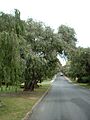
Peppermint trees form an avenue in Keane Street
-
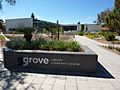
The Grove Library, Peppermint Grove


