Peros Banhos facts for kids
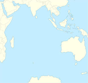
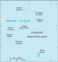
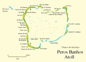
Peros Banhos is a group of islands in the Chagos Archipelago. It's part of the British Indian Ocean Territory. People used to live here, but they were moved away.
One island, Île Yeye, is in the northeast part of Peros Banhos. It is the closest island in the Chagos Archipelago to the Maldives.
Contents
Exploring Peros Banhos: Geography
Peros Banhos is an atoll. An atoll is a ring-shaped coral reef with islands around a central water area called a lagoon. This atoll covers a total area of 503 square kilometers. However, the actual land area of its 32 small islands is only about 9.6 square kilometers.
Most of the atoll's area, about 490 square kilometers, is taken up by the lagoon. This lagoon is connected to the open sea. The atoll is surrounded by a coral reef, much like those found in the nearby Maldives. The lagoon, known as Baie de Peros Banhos, is just over 20 kilometers wide.
All the islands in Peros Banhos are flat and sandy. The larger islands are covered with coconut trees.
Main Islands of the Atoll
The biggest and most important island is Île du Coin. This island was once home to a settlement called Perch. From here, people managed the coconut farms on the atoll. Île du Coin was also the main port for the atoll. It had a special dock for loading and unloading goods.
Île du Coin was the only island where people lived all the time. Other important islands had buildings and were sometimes lived on. These include Grande Soeur, Île Diamant, Île Manoël, and Île Pierre. All these islands were part of the large coconut farm run from Île du Coin.
Île Yeye is at the northeast corner of the atoll. It is the closest island in the Chagos to the Maldives. The distance between Île Yeye and Gan Island in the Maldives is 523 kilometers.
Changes in the Landscape
The geography of Peros Banhos has changed over time. For example, Île St. Brandon used to be covered with coconut trees. Now, it is just a sandbank. On the other hand, an island north of Île Verte was a small sandbank in 1837. Today, it is a medium-sized island with plants growing on it.
A Look Back: History of Peros Banhos
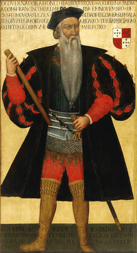
Peros Banhos was discovered in 1513 by a Portuguese explorer named Afonso de Albuquerque. The atoll's name comes from "Pêro dos Banhos." This was another Portuguese explorer who died there after his ship crashed on the reefs.
Early Stories of Survival
One of the oldest stories about Peros Banhos was written by Manoel Rangel. He was a survivor from a Portuguese ship called Conceição. This ship crashed on the Peros Banhos reefs in 1556.
About 165 people survived the shipwreck. They were left on a flat, sandy island in Peros Banhos. At that time, there were no coconut trees on the island. Rangel wrote that there were weeds and grasses. He also said that about ten thousand birds lived on the island. The survivors ate the birds to stay alive. But when most of the birds were gone, many people started to die.
Manoel Rangel also mentioned that they found drinking water. They did this by digging shallow wells in the sand. Many turtles also came to lay their eggs on the island's beach.
Life on the Islands
Since 1756, Île du Coin was home to many people, sometimes up to 500. Most of these people were called the Ilois. They worked on the coconut farms and in the industry that made oil from coconuts. The Ilois were Christian. There were churches and primary schools in Peros Banhos before the people were moved away. Their language was a special kind of French called Chagossian Creole.
There is a small, bushy island called Île Diable in the northwest of the atoll. The name of this islet, which means "Devil Island," suggests that local people had some interesting folk beliefs.
Moresby Island, in the north of Peros Banhos Atoll, is named after Robert Moresby. He was a British mapmaker who created the first accurate maps of the Chagos Archipelago in 1837. After his work, the first detailed map of Peros Banhos Atoll was published.
Moving the People Away
In 1970, the British Government moved all the people from Peros Banhos Atoll. They were sent to live in Mauritius. Recently, people have looked into the idea of letting people live on the islands again. However, for now, no one is allowed to visit without special permission.
Protecting Nature: Peros Banhos Nature Reserve
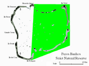
A special part of the atoll is called the Peros Banhos Atoll Strict Nature Reserve. This area is east of a line between Moresby Island (north) and Fouquet Island (south).
It is against the rules to enter this reserve. It is also forbidden to go within 200 meters of the islands inside the reserve. The British Indian Ocean Territory has clear rules about what activities are allowed or not allowed here.
People on yachts are told not to even drop anchor within the Peros Banhos Atoll Strict Nature Reserve. This helps protect the delicate natural environment.
Islands of Peros Banhos
Peros Banhos Atoll has about 32 small islands. This is about half of all the islands in the Chagos Archipelago. The islands are listed below, going clockwise around the atoll, starting from the south:
| Map of Peros Banhos | Southwest rim (between southern channel and Passe de l'Île Poule) | Northwest rim (between Passe de l'Île Poule and Moresby Channel) | Eastern part (east of southern channel and Moresby Channel) |
|---|---|---|---|
|
|
|
Passe de l'Île Poule is also known as Passe Elisabeth on older maps.
The islands in the eastern part are part of the Peros Banhos Strict Nature Reserve. However, Île De La Passe and Moresby Island are not part of the reserve.
See also
 In Spanish: Peros Banhos para niños
 | Shirley Ann Jackson |
 | Garett Morgan |
 | J. Ernest Wilkins Jr. |
 | Elijah McCoy |


