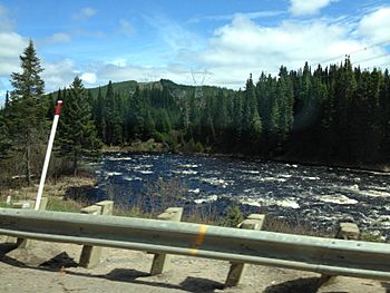
Petite rivière Pikauba facts for kids
Quick facts for kids Petite rivière Pikauba |
|
|---|---|
 |
|
| Country | Canada |
| Province | Quebec |
| Region | Saguenay-Lac-Saint-Jean |
| Regional County Municipality | Le Fjord-du-Saguenay Regional County Municipality |
| Unorganized territory and a city | Lac-Pikauba and Saguenay |
| Physical characteristics | |
| Main source | Lac Desjardins Lac-Pikauba 928 units? 47°51′55″N 71°08′15″W / 47.865315°N 71.13759°W |
| River mouth | Pikauba River Lac-Ministuk 348 m (1,142 ft) 48°19′29″N 71°26′27″W / 48.32472°N 71.44083°W |
| Length | 74.1 km (46.0 mi) |
| Basin features | |
| Tributaries |
|
The Petite Rivière Pikauba is a river in Quebec, Canada. It's like a smaller helper river that flows into the bigger Pikauba River. This river runs through two main areas: Lac-Pikauba and Lac-Ministuk.
What's special about the Petite rivière Pikauba is that it flows entirely inside the amazing Laurentides Wildlife Reserve. This means it's surrounded by beautiful nature! You can usually get to the river using main roads like Route 169 and Route 175, which connect cities like Quebec and Chicoutimi. Other smaller forest roads also help people get around for logging and fun outdoor activities.
People started using the forests around the river for logging in the late 1800s. This also led to more hunting and fishing in the area. The river usually freezes over from late November to early April. But it's generally safe to walk or play on the ice from mid-December to late March.
Contents
River's Journey: Where it Starts and Flows
The Petite Rivière Pikauba begins its journey at a lake called Lac Desjardins. This lake is found right in the middle of the Laurentides Wildlife Reserve. Lac Desjardins is about 0.5 kilometers long and sits very high up, at 928 meters above sea level!
From Lac Desjardins, the Petite rivière Pikauba flows for about 74.1 kilometers. As it travels, it drops a total of 580 meters in height.
Upper Part of the River
In its upper section, the river flows south, then west, passing through lakes like Lac Lanctôt. It continues southwest, then southeast, crossing Lake Beloeil. The river then turns northwest, picking up water from other lakes like Lake Fitou. Finally, it flows into the northern part of Talbot Lake, which is about 7.5 kilometers long.
Middle Part of the River
After Talbot Lake, the river continues its journey for about 19.4 kilometers. It flows northwest through a deep valley, even crossing Route 175. It winds its way through the valley, picking up water from smaller streams like the Jean-Baptiste stream.
Lower Part of the River
The final part of the river's journey is about 27.4 kilometers long. It flows northwest, collecting water from streams like In stream and the outlet of Lake Ondée. It also gets water from lakes Albert and Paul. The river then forms several loops and crosses some rapids before reaching its end.
Where the River Ends
The Petite Rivière Pikauba finally flows into a bay on the south shore of Kenogami Lake. This meeting point is about 1 kilometer west of Pointe Finnigan.
From there, the water from the Petite Pikauba River joins the Pikauba River and flows north for about 26.5 kilometers. Then, it crosses Kenogami Lake for about 17.6 kilometers towards the northeast. After that, it follows the Chicoutimi River for about 26.2 kilometers, heading east and then northeast. Finally, it joins the mighty Saguenay River for about 114.6 kilometers, flowing east until it reaches Tadoussac. At Tadoussac, the Saguenay River merges with the huge Saint Lawrence estuary.
River's Name: Toponymy
The name "Petite rivière Pikauba" was officially recognized on January 8, 1981. This was done by the Commission de toponymie du Québec, which is the official group in Quebec that names places.
Related Places
Other Important Locations
- Charlevoix Regional County Municipality
- Le Fjord-du-Saguenay Regional County Municipality
- Laurentides Wildlife Reserve
- Lac-Pikauba, an unorganized territory
- Lac-Ministuk, an unorganized territory
- Talbot Lake, a body of water
- Saguenay River, a stream
- Chicoutimi River, a stream
- Kenogami River, a body of water
- Pikauba River, a stream
- List of rivers of Quebec
 | Valerie Thomas |
 | Frederick McKinley Jones |
 | George Edward Alcorn Jr. |
 | Thomas Mensah |

