Petite rivière du Chêne facts for kids
Quick facts for kids Petite rivière du Chêne |
|
|---|---|

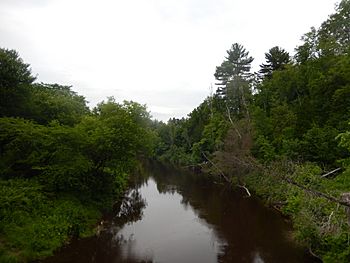
Petite rivière du Chêne from the bridge of the “Le Petit-Deschaillons” cycle path
|
|
| Country | Canada |
| Province | Quebec |
| Region | Centre-du-Québec |
| MRC | L'Érable Regional County Municipality, Bécancour Regional County Municipality |
| Physical characteristics | |
| Main source | Agricultural and forest streams Notre-Dame-de-Lourdes 128 metres (420 ft) 46°20′40″N 71°52′45″W / 46.34438°N 71.87912°W |
| River mouth | St. Lawrence River Deschaillons-sur-Saint-Laurent 5 metres (16 ft) 46°33′26″N 72°02′18″W / 46.55722°N 72.03833°W |
| Length | 35.4 kilometres (22.0 mi) |
| Basin features | |
| River system | St. Lawrence River |
| Tributaries |
|
The Petite rivière du Chêne (which means Little Oak River in English) is a small river in Quebec, Canada. It flows into the mighty St. Lawrence River from its south side. This river travels through several towns, including Notre-Dame-de-Lourdes, Villeroy, Manseau, Fortierville, Parisville, and Deschaillons-sur-Saint-Laurent. These towns are part of the Centre-du-Québec region.
Contents
River's Journey
The Petite rivière du Chêne starts its journey in a forest area near the town of Notre-Dame-de-Lourdes. Its source is about 3.6 kilometres (2.2 mi) north of Lourdes village.
From there, the river flows for about 63 kilometres (39 mi), dropping 123 metres (404 ft) in elevation. It winds its way through different landscapes, including agricultural fields and forests.
Where the River Flows
The river's path can be split into two main parts:
- Upper Course: This part is about 35.4 kilometres (22.0 mi) long. The river generally flows west through Villeroy and then turns northwest. It crosses Highway 20 and Route 218. It winds a lot, eventually heading north until it meets the Creuse River.
- Lower Course: After joining the Creuse River, the Petite rivière du Chêne flows for another 28.2 kilometres (17.5 mi). It continues north, then northwest, often following Route 226. It then turns northeast, crossing Route 265 and Route 132.
River's End
Finally, the Petite rivière du Chêne reaches the wide estuary of the St. Lawrence River. It joins the St. Lawrence near a place called Pointe Des Robert, between the towns of Deschaillons and Leclercville. This is its mouth, where it empties into the much larger river.
What's Around the River?
The area around the Petite rivière du Chêne is called its watershed. This is the land where all the rain and snow eventually drain into this river.
- To the north, the river meets the St. Lawrence River.
- To the east, it is close to streams like L'Esperance, rivière au Chêne, rivière aux Ormes, Creuse River, and Geoffroy stream.
- To the south, the Bécancour River is a major neighbor.
- To the west, it is also near the St. Lawrence River and other rivers like rivière aux Orignaux and rivière aux Glaises.
Naming the River
The name Petite rivière du Chêne means "Little Oak River." It's connected to the Abenaki language, where "wachilmezi" refers to an oak acorn. This suggests that oak trees or acorns were important in the area.
The name "Petite rivière du Chêne" was officially recognized on December 5, 1968, by the Commission de toponymie du Québec, which is like the official naming committee for places in Quebec.
 | Leon Lynch |
 | Milton P. Webster |
 | Ferdinand Smith |


