Piawaning, Western Australia facts for kids
Quick facts for kids PiawaningWestern Australia |
|
|---|---|

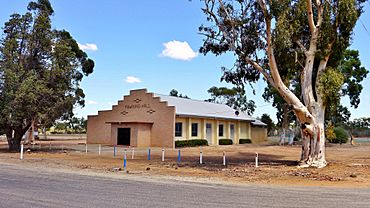
Piawaning Hall, 2016
|
|
| Established | 1920 |
| Postcode(s) | 6572 |
| Elevation | 326 m (1,070 ft) |
| Area | [convert: needs a number] |
| Location |
|
| LGA(s) | Shire of Victoria Plains |
| State electorate(s) | Moore |
| Federal Division(s) | Durack |
Piawaning is a small town located in the northern farming area of Western Australia. It is about 160 kilometers (100 miles) north-east of Perth, the capital city. It is also 28 kilometers (17 miles) north-east of the historic town of New Norcia. In 2006, about 309 people lived in Piawaning.
Contents
Discover Piawaning's History
How Piawaning Began
The idea for a railway line to extend north from Toodyay to Bolgart started in 1913. This new line was planned to end near a place called Piawaning Spring.
By 1919, the exact path for the railway was decided. The government then chose to create a town at the end of this railway line. They named the new town Piawaning.
The Meaning of the Name
The name Piawaning was chosen because it was the closest Aboriginal name for the area. The town was officially recognized in 1920.
Piawaning Spring has been on maps since 1877. A surveyor first recorded it then. However, the exact meaning of the name "Piawaning" is not known today.
What Piawaning Produces
Farming in the Area
The land around Piawaning is very good for farming. Farmers in this region mainly grow wheat and other cereal crops. Cereal crops include grains like barley and oats.
Grain Handling Site
Piawaning is an important collection point for these crops. It is a "receival site" for Cooperative Bulk Handling (CBH). This means that farmers bring their harvested grains to Piawaning. CBH then stores and manages these grains.
 | Claudette Colvin |
 | Myrlie Evers-Williams |
 | Alberta Odell Jones |


