
Pic de Marboré facts for kids
Quick facts for kids Pic de Marboré |
|
|---|---|
| Marboré Peak | |

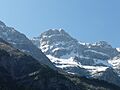
Westside of Pic de Marboré. Below Glacier de la Cascade and Grande Cascade de Gavarnie
|
|
| Highest point | |
| Elevation | 3,248 m (10,656 ft) |
| Geography | |

Pic de Marboré
Location in Pyrenees
|
|
| Région Communauté |
Midi-Pyrénées Aragon |
| Département Province |
Hautes-Pyrénées Huesca |
| Parent range | Monte Perdido Range (Pyrenees) |
| Climbing | |
| First ascent | 24 September 1865 by Henry Russell and Hippolyte Passet |
| Easiest route | From Refuge de Goriz |
Marboré Peak (also called Pic de Marboré or El Marboré) is a tall mountain in the Pyrenees mountain range. It stands right on the border between France and Spain. This peak is part of the Monte Perdido Range, which is famous for its beautiful scenery.
Contents
Where is Marboré Peak?
Marboré Peak is one of the many impressive mountains found above the Cirque de Gavarnie. A "cirque" is a huge, bowl-shaped valley carved by glaciers.
This peak acts as a natural border. It separates the Pyrenees National Park in France from the Ordesa y Monte Perdido National Park in Spain. Both of these are special areas created to protect nature.
Location in France
On the French side, Marboré Peak is located in a town called Gavarnie. This town is part of the Hautes-Pyrénées area in the Midi-Pyrénées region.
Location in Spain
On the Spanish side, the peak is in the Sobrarbe area. This is in the Huesca province, which is part of the Aragon community.
History of Climbing
People have been exploring Marboré Peak for a long time. It is thought that Philippe de Nemours might have been the first person to climb this peak in 1846. However, we don't have all the details to be completely sure.
The first confirmed climb was on September 24, 1865. Two explorers, Henry Russell and Hippolyte Passet, successfully reached the top.
See Also
 In Spanish: Pico Marboré para niños
Images for kids
-
Marboré Peak seen from Belvédère, north of Cirque de Gavarnie.

