Picnic Point, Toowoomba facts for kids
Quick facts for kids Picnic Point, Toowoomba |
|
|---|---|
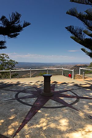
Picnic Point Lookout, 2013
|
|
| Location | 168 Tourist Road, Rangeville, Toowoomba, Queensland, Australia |
| Official name: Picnic Point and adjacent Parkland | |
| Type | state heritage (built, landscape) |
| Designated | 13 November 2008 |
| Reference no. | 601205 |
| Significant period | 1880s onwards |
| Lua error in Module:Location_map at line 420: attempt to index field 'wikibase' (a nil value). | |
Picnic Point is a special park in Toowoomba, Queensland, Australia. It's located at 168 Tourist Road, Rangeville. This park is listed on the Queensland Heritage Register, which means it's an important historical place. It was added to the list on November 13, 2008.
Picnic Point sits high up on a bluff, which is like a steep cliff, along the top of the Great Dividing Range. From here, you can see amazing views of the deep valleys and hills below. It has been a popular spot for people to relax and have fun for over a century.
History of Picnic Point
Picnic Point and the land around it cover about 65 hectares (about 160 acres). In 1886, the first part of this area was set aside as a reserve. It was chosen by William Henry Groom, who was the first Lord Mayor of Toowoomba. He thought it was a very beautiful spot with great views.
Why it's called Picnic Point
The word "picnic" comes from a French term, "picque-nique." By the early 1700s, it meant an informal meal where everyone brought their own food. Picnics became very popular in Britain in the 1800s. When British people moved to Australia, they found the warm weather and open spaces perfect for continuing this tradition.
Picnics in public parks were a great way for families and friends to gather. They could enjoy each other's company in a nice outdoor setting. It's interesting that from the very beginning, in 1886, this area was named Picnic Point.
Protecting the Land
In 1888, people in Toowoomba asked the government to protect about 2000 acres of land, including Picnic Point. They wanted it to be a public park forever. They described the land as "replete with beauty" and "full of picturesque effects." They said it had "grassy slopes and rugged mountain gullies" with "rippling streams."
The people wanted this beautiful land to be saved for future generations. They also noted that Toowoomba was becoming a popular place for people to visit for their health. They believed having such a delightful park would make the town even better.
This request showed how much people valued natural landscapes. It also showed a belief that spending time outdoors was good for people's health. Even though the big request wasn't fully acted on, more land was slowly added to the Picnic Point reserve over the years.
Quarry and Survey Station
For a while, there was a quarry nearby that dug up stone for roads. This quarry operated until 1940, when it became part of the park.
Because Picnic Point is so high up, it was also chosen for a special survey station between 1883 and 1891. This station helped map out Queensland.
Growing the Park
The park grew over time. In 1902, the local council bought more land. By 1906, they started planting trees at Picnic Point. More land was added in 1909 and 1910, making the park even bigger.
In 1910, Picnic Point was also declared a "Reserve for the Protection and Preservation of Native Birds." This meant it was a safe place for birds. People believed that the trees planted along Tourist Road, leading to Picnic Point, were put there around this time. These trees would eventually form a "noble thoroughfare" or grand pathway.
Early Facilities and Views
Even though parts of the park were used for grazing animals, Picnic Point remained a popular spot. In 1920, a kiosk (a small building selling refreshments) was built. It was completed in 1921. One rule for the kiosk was that it couldn't stop people from freely using the park for fun.
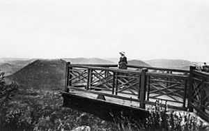
The council also built a lookout platform. This platform hung out over the cliff, giving amazing views of Tabletop Mountain and the Lockyer Valley. Building lookouts and other facilities was common in parks during the 1920s and 1930s. They helped visitors enjoy the views safely.
In 1930, a company called Kodak (Australasia) Pty Ltd offered to put up a stone marker, called a cairn. This cairn would have a brass plate showing the names and directions of landmarks visible from Picnic Point. This was a great idea for visitors.
Park Improvements and Wartime Use
During the Great Depression in the 1930s, many public parks were improved using special government programs. At Picnic Point, a camping ground was leveled out. Visitors praised the good camping facilities.
During World War II, from 1942 to 1943, the First Australian Army used the kiosk and the park area. After they left, some fences were broken, and cars drove everywhere. The local community asked the council to fix the park and restore it for public use.
After 1945, Picnic Point continued to be a very popular place for both locals and tourists. More land was added to the park in 1949. A report in 1951 noted that the park was "used extensively as a tourist attraction" because of its "wonderful view."
New Kiosk and Puppy Memorial
In the 1950s, the park saw more improvements. In 1954, the council got a loan to build paved pathways around the cliff edge and to the lookout.
A new, bigger kiosk building was planned in 1956 and opened on September 13, 1958. This showed how popular Picnic Point had become.
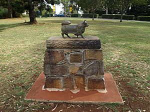
A special memorial was put up in 1959 for "Puppy," the mascot of the Toowoomba Thistle Pipe Band. Puppy was a dog who led the band in the annual Carnival of Flowers parade. He was very popular. Sadly, Puppy was hit by a car and died during the 1958 parade. The community was very sad, and the statue was erected to remember him. The statue was stolen twice but was found both times.
Modern Developments
The 1960s brought more changes. In 1963, a distinctive "mushroom" shaped water tower was built. Tobruk Memorial Drive was also opened. This road allowed cars to access more grassy picnic areas with great views. This helped people enjoy the natural Australian bushland.
In 1965, a waterfall feature was opened at the site of the old quarry. This project was supported by the Carnival of Flowers Association.
In the 1970s, a small television tower was built. The kiosk building was damaged by fire in 1976 but was later renovated and extended. In 1977, a group wanted to build an amusement park in the area, but the council refused. They said it would stop the public from freely using the park.
Protecting the Views
In the late 1980s and early 1990s, there was a big debate in Toowoomba. Some plans for the kiosk involved building tall accommodation facilities. People were very upset, with headlines like "Save Picnic Point from High Rise" appearing in the newspaper. A group called the Picnic Point Preservation Group was formed. They worked hard to stop the tall buildings.
By 1994, the plans were changed, and the idea of a high-rise tower was dropped. The old kiosk was taken down in 1995, and a new one opened in 1996. This new building was designed to be set into the hillside so it wouldn't block the views from the park.
Since then, new lookout platforms have been built, and a Master Plan was created in 1995 to guide future improvements to the park. The stone directional cairn and the Puppy Memorial were also moved slightly to their current locations.
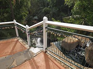
In 2013, a local couple started a trend of attaching "love locks" to the lookout above the waterfall. They threw the key into the waterfall to symbolize their love. Many other couples have followed this tradition, making it a popular spot for love locks.
Exploring Picnic Point Today
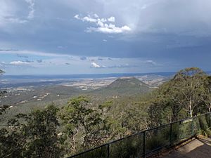
When you drive to Toowoomba from Brisbane, you can see the Great Dividing Range rising impressively. Picnic Point is high up on this range. The recreation areas are hidden until you arrive, making the experience even more special.
The Approach and Lions Park
As you drive along Tourist Road towards Picnic Point, you'll pass through an avenue of tall hoop pine and kauri pine trees. These might be the "noble thoroughfare" that people imagined over a hundred years ago.
The first big park area you'll see is Lions Park, on the left side of the road. It has open grassy areas with different kinds of trees. There's a children's playground and a bluestone shed that stores a children's train. The Lions Club operates this train on weekends. If you walk east through this park, you'll reach the waterfall area, which isn't visible from the road.
Central Precinct and Primary Viewing Area
A tall flagpole, built in 2009 to celebrate Queensland's 150th birthday, marks your arrival at Picnic Point. It can be seen from far away.
To the right of the road is the Central Precinct. This area has many mature Hoop Pines and Blakely's Red Gum trees. Underneath these trees, you'll find another children's playground, a band rotunda, and picnic tables. These old trees might be some of the "ornamental trees" planted by the park's curator in 1913.
As you get closer to the main lookout, you'll see a small information shelter. Beyond that, a fence marks the edge of the cliff. To the right, there's a car park. When you get out of your car, you'll be drawn to the main viewing area next to the kiosk.
A wide path leads to a stone cairn with a brass plate on top. This is likely the marker provided by Kodak in 1930. From here, countless visitors have taken photos with Tabletop Mountain in the background. Stairs lead down to walking paths along the cliff face. The Puppy Memorial is also located prominently here.
The Kiosk and Water Tower
The kiosk building forms the southern edge of the main viewing area. It looks small, but it's actually a large facility with function rooms and a popular cafe. Much of the building is built into the hillside, so it doesn't block the amazing views of the Lockyer Valley. To the west of the kiosk, you'll see the unique mushroom-shaped water tower, which is a key landmark at Picnic Point.
From the lower level of the kiosk, you can go out onto a terrace that leads to the escarpment walking track. This path offers more close-up views of the valley.
Waterfall and Other Lookouts
Further along the path, you'll enter the waterfall area, which is where the old quarry used to be. This area is filled with tropical plants, making it cool and shady. Large stepping stones guide you around the base of the waterfall. There's also a small rotunda here, often used for celebrations like weddings.
If you walk further west, you'll find the Bill Gould Lookout, which offers views down to the Warrego Highway. Stone paths and stairs lead through terraced gardens, bringing you to the top of the old quarry and a viewing platform above the waterfall.
Tobruk Drive and Heller Street Park
You can also explore more of the park by car along Tobruk Drive. This road runs east behind the kiosk through an open forest. This area has a more natural, bushland feel, with picnic facilities, barbecues, and park furniture. Low log barriers stop cars from driving onto the grassy areas. At the end of the road is the Bob Dodd's Lookout.
To the south of the road, a gully is being replanted with rainforest trees by volunteers. There's also a small dam to water the new plants. Several walking tracks, like the Pardalote Walk and Fantail Circuit, wind through this area. They even connect to a Bridle Trail that leads to Tabletop Mountain for keen hikers.
Crossing Heller Street, you'll enter the Heller Street Park precinct. This part of the park is less developed but still offers a large children's playground with different activities. It also has open grassy areas for games. A new toilet block and parking area are in the north-east corner. From here, you can enjoy wide views across the suburbs of Toowoomba.
As you leave Picnic Point, the avenue of mature trees along Tourist Road closes in the views, completing your unique experience of this special park.
Why Picnic Point is Special
Picnic Point and the parkland around it were added to the Queensland Heritage Register on November 13, 2008, for several important reasons:
A Long History of Fun
This place has been used for public recreation and enjoying nature for a very long time, ever since European settlement. Its continued use shows how important these activities are to people in Queensland.
Great Design and Scenery
Different parts of the park show important ideas and styles used in designing public parks and natural landscapes. The park is also incredibly beautiful. From Picnic Point, you get a 180-degree view of the Great Dividing Range, including the amazing Scenic Rim area. Many visitors and famous people have praised the beauty of this view over the years.
Important to the Community
Picnic Point is very important to the Toowoomba community. It's also well-known across Queensland and Australia as a beautiful public recreation area. It offers wide, stunning views from the top of the Great Dividing Range, looking out over the coastal plains to the east.
 | DeHart Hubbard |
 | Wilma Rudolph |
 | Jesse Owens |
 | Jackie Joyner-Kersee |
 | Major Taylor |


